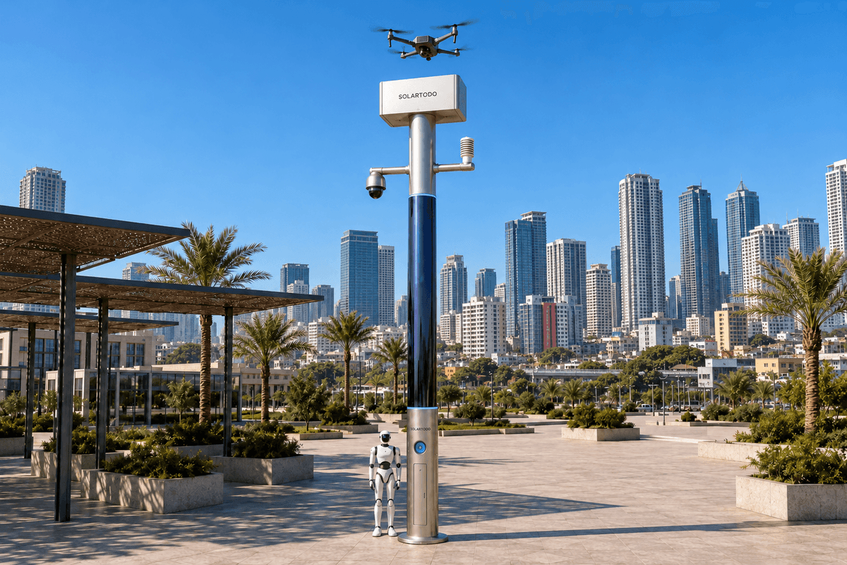
A City AI Pole is a non-lighting physical-AI edge node combining local computing, sensing, autonomous drone operations and ground robot support. SOLARTODO Sentinel’s Sky Hub form runs OTATODO at the edge using battery storage and on-pole solar replenishment. This proposed Manila deployment coordinates human-authorized nighttime fire assessment across cultural-tourism zones while keeping raw video and sensor data on each pole.
1. Define the city task: nighttime fire assessment during a heatwave
For Manila city management, the operational question is specific: how can a night command team obtain useful situational awareness around a suspected fire while preserving visitor access, responder routes and heritage assets? This case study proposes a grid-mesh deployment of SOLARTODO Sentinel Sky Hub nodes around selected cultural-tourism zones. It describes a planning configuration, not a completed Manila installation or achieved performance record. Sentinel is positioned as a mature, in-service product; local siting and operating conditions remain subject to final engineering confirmation.
Intramuros provides a concrete planning context. Its official visitor information identifies heritage destinations including Fort Santiago, Manila Cathedral and San Agustin Church. These locations establish the cultural-tourism setting; their inclusion does not imply participation, procurement or permission to install equipment. The city would select actual observation areas and response corridors through site surveys and stakeholder consultation. Intramuros Administration visitor information
The seasonal trigger is a heatwave readiness period. City management would use official weather information alongside its own response procedures to adjust staffing, inspection priorities and battery reserves. PAGASA publishes heat-index information that can inform readiness decisions; a heat alert does not itself establish that a fire exists. PAGASA heat-index information
The primary outcome to evaluate is coverage: the share of agreed priority locations for which the command team can obtain an authorized, operationally useful assessment during the night window. Drone-nest availability, safe flight access and clear command responsibility matter more than a theoretical circle drawn around each pole.
2. Place the drone-nest mesh around response corridors
The deployment plan begins with a map of priority observation areas, potential launch positions, pedestrian activity, responder access and places where flight must be excluded. Candidate positions near the Intramuros perimeter and connecting visitor corridors would be assessed individually. Heritage sightlines, foundation constraints, landing clearance, communications and maintenance access determine suitability. No installation on a heritage structure is assumed.
Grid-mesh describes the spatial arrangement and communications coordination of independent nodes. It does not describe an electricity connection: every Sky Hub remains fully off-grid, with no grid, city or site power. Neighboring nodes exchange de-identified event and status metadata so the command view can identify an available nest when another node is occupied, energy-constrained or unavailable. Raw video and sensor data stay on their originating pole.
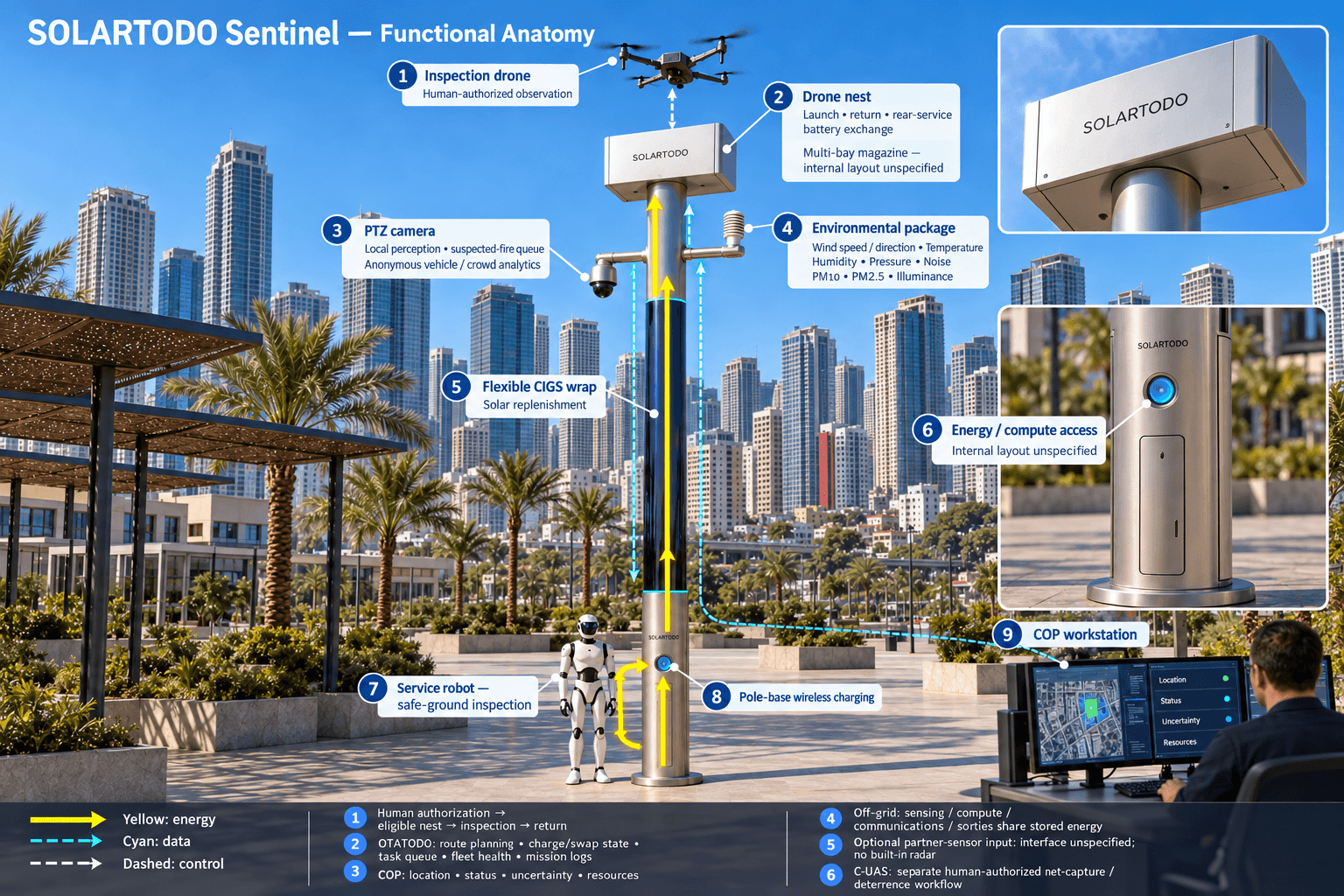
The drone nest is the operational center of this configuration. Following an authorized launch, a drone conducts regional patrol or a focused inspection, returns, and can receive another queued assignment. A multi-bay battery magazine performs an automated rear-service battery exchange after landing. A charged pack supports relaunch, while multiple bays support several consecutive sorties within aircraft, battery and energy limits. No operator is required beside the nest; command supervision and authorization remain active.
Coverage therefore includes continuity between tasks. The planning team should test whether an adjacent nest can take an inspection assignment while the first drone returns or exchanges batteries. It must also identify locations that remain unobservable because of obstructions, weather restrictions or operating permissions. Those gaps belong on the city’s coverage map.
3. Run one authorized detect-to-response loop
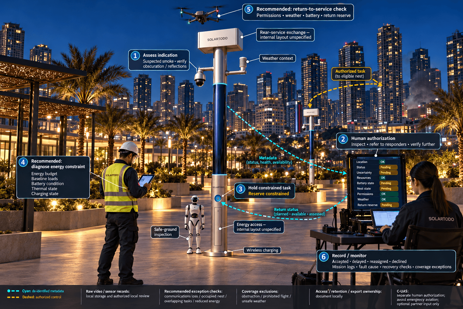
At night, an on-pole PTZ camera supplies local perception for intrusion, perimeter awareness, anonymous vehicle counts and crowd density. A suspected smoke or fire indication enters an assessment queue; it is not automatically treated as a confirmed emergency. Darkness, obscuration and reflections can limit interpretation, so camera suitability and nighttime observation procedures require site verification. The system does not use face or licence-plate recognition as active capabilities.
OTATODO schedules local inference and correlates the event with available context. The environmental package measures wind speed, wind direction, temperature, humidity, atmospheric pressure, noise, PM10, PM2.5 and illuminance. Wind and particulate readings can support assessment, but they do not independently prove a fire. A de-identified event summary reaches the common-operating-picture command view with location, status, uncertainty and available response resources.
The designated human authorizer reviews the summary and chooses whether to request a drone inspection, refer the report directly to fire responders, or seek further verification. The drone operations manager checks route permissions, weather limits, battery condition, return reserve and nest availability before releasing the task. Its route planning, charge/swap state machine, task queue, fleet health and mission logs support repeatable operations. An aircraft must not obstruct emergency aviation or enter an unsafe fire environment.
The drone’s role is observation and inspection, not firefighting. Raw mission video and sensor records remain on the associated pole for local processing and authorized local review; only de-identified event or status metadata may leave it. Responders receive actionable summaries rather than an assumed remote raw-video feed.
A service or humanoid robot can inspect a safe ground approach, support alarm response and coordinate with the aerial task. It returns to the pole base for wireless charging. It is not assigned entry into a burning building. The shared loop is sensing, authorized assessment and response, edge-compute scheduling, then field operations and maintenance, with human authorization visible throughout.
4. Protect night coverage with an honest energy budget
Night-response coverage depends on stored energy. The proposed cylindrical Sky Hub uses approximately 15 m² of flexible CIGS thin-film wrapped through 360° around a roughly 8 m tall, 0.6 m-wide body. Its solar nameplate is approximately 2.4–2.7 kWp. These dimensions describe a pure smart pole with no lighting system.
Nameplate capacity must not be presented as continuous field output. A vertical cylinder receives direct sunlight on its sun-facing projection, not across the entire wrap simultaneously. In a high-irradiance reference region such as Saudi Arabia, realistic clear-sky production is roughly 0.8–1.1 kW DC peak and about 6–9 kWh per day, with peaks tending toward mid-morning or afternoon rather than noon. These reference figures are not a Manila generation forecast.
The CIGS layer provides supplemental replenishment to a fully off-grid, battery-backed micro-station. Proposed storage is in the 5–20 kWh class, with final capacity determined by measured baseline loads, battery operating limits, weather allowances and the intended duty cycle. Storage buffers high-power drone exchanges, battery charging and robot activity; it does not create additional energy. Sustained operation requires a validated balance between replenishment and consumption.
For Manila, engineering must account for shading, cloud cover, seasonal conditions, heat, wind exposure and battery thermal management. Before the night window, OTATODO allocates an energy budget to sensing, compute, communications and authorized sorties. Lower-priority patrols can be deferred to preserve emergency assessment capacity. When energy or weather prevents a mission, the COP must show that loss of coverage explicitly and direct the task to another available resource.
5. Evaluate coverage, document exceptions and govern operations
City management should define the coverage denominator before evaluating the system. A priority location counts as covered only when the agreed assessment task is feasible under the recorded conditions: the nest is available, permissions are valid, energy reserve is sufficient and the observation can answer the operational question. Separate planned coverage, available coverage and successfully assessed locations. Do not count an obstructed view or prohibited flight as operational coverage.
Evaluation should include ordinary nighttime patrol, overlapping incident requests, an unavailable nest, communications loss and reduced energy availability. Record why each task was accepted, delayed, reassigned or declined. Review the resulting gaps with fire-response personnel, cultural-site stakeholders and maintenance staff. The illustrative calculations below establish recomputable planning inputs; none represents measured Manila performance, a deployment commitment or a promised result.
Local processing also shapes governance. Raw video and sensor data stay on the pole. Access controls, retention periods, local review procedures and de-identified exports require documented ownership. The design is PDPL/LGPD-oriented through local processing, but this is not certification or proof of Philippine legal compliance. Applicable local requirements and aviation permissions need separate review before operation.
Counter-UAS coordination is a distinct, authority-bound workflow. Sentinel detects and tracks an unauthorized drone and, only after human authorization, commands its own friendly drone for soft aerial net-capture or close-approach deterrence. Any such operation must avoid interfering with fire response. Radar is not built into the pole; an optional partner sensor may supply an input. This capability does not grant an automatic right to intervene.
The final operating plan should assign responsibility for authorization, flight supervision, battery servicing, robot access, local evidence review and recovery after faults. Acceptance requires documented coverage observations and engineering confirmation, rather than claims inferred from equipment presence.
System Configuration
| Parameter | Configuration |
|---|---|
| Node form and energy | Pure non-lighting cylindrical pole; approximately 8 m tall and 0.6 m wide; fully off-grid with approximately 15 m² of wrapped flexible CIGS and 5–20 kWh-class battery storage, subject to final engineering. |
| Drone nest | Autonomous launch and return interface with automated rear-service battery exchange and a multi-bay charged-pack magazine. |
| Drone operations management | Route planning, charge/swap state machine, mission queue, fleet-health monitoring and mission logs. |
| Edge compute and data | On-pole AI compute running OTATODO; local inference and raw-data retention; de-identified event/status metadata export only. |
| Security and environment | PTZ camera with anonymous analytics; wind speed/direction, temperature, humidity, pressure, noise, PM10, PM2.5 and illuminance sensing. |
| Ground robot interface | Service or humanoid robot for safe-area patrol, alarm response and inspection, with wireless charging at the pole base. |
| Coordination | Metadata communications mesh and human-authorized COP; non-lethal C-UAS coordination; optional partner-sensor inputs, with no built-in radar. |
How It Works
- On-pole perception flags a suspected fire indication for local assessment.
- OTATODO correlates sensor context and issues a de-identified event summary.
- A human authorizer decides the response after reviewing operating constraints.
- The scheduler assigns an eligible drone nest and reserves return energy.
- The drone inspects, returns and receives an automated battery exchange when required.
- Raw records stay on-pole; de-identified outcomes and coverage exceptions update the COP.
Planning Assumptions (Indicative)
Illustrative planning inputs a buyer can recompute — target metrics, not achieved results. Subject to final engineering confirmation.
| Metric | Planning assumption | Indicative value |
|---|---|---|
| Priority-location coverage target | ILLUSTRATIVE ONLY: define 20 priority observation locations and target assessability at 16 under agreed night operating conditions. | 16 ÷ 20 × 100 = 80% target coverage; not an achieved outcome. |
| Night coverage evaluation window | ILLUSTRATIVE ONLY: evaluate 8 hours per night across 5 nights. | 8 × 5 = 40 hours of planned evaluation. |
| Inspection task demand | ILLUSTRATIVE ONLY: budget 6 inspection assignments per night with 10 minutes of airborne observation per assignment. | 6 × 10 = 60 airborne observation minutes per night; excludes transit, reserves and battery exchange. |
| Storage allocation exercise | ILLUSTRATIVE ONLY: start with 10 kWh nominal storage and allocate 60% to a planning energy envelope before task-specific engineering. | 10 × 0.60 = 6 kWh planning allocation; not a validated usable capacity or endurance claim. |
| Operational review effort | ILLUSTRATIVE ONLY: hold 2 review sessions weekly for 4 weeks, each lasting 30 minutes. | 2 × 4 × 30 = 240 minutes of planned review effort. |
Deployed Equipment
- Proposed Sky Hub pure smart-pole assembly with cylindrical flexible CIGS wrap
- Battery-storage cabinet with energy management and protective controls
- Drone nest with multi-bay battery magazine and rear-service exchange mechanism
- Inspection drone configured for authorized night operations
- On-pole edge-compute enclosure and local storage
- PTZ camera and nine-parameter environmental sensor package
- Service or humanoid robot with pole-base wireless charging interface
- Metadata mesh communications equipment
Frequently Asked Questions
Is this an installed Manila project with verified results?
No. This is a proposed Manila configuration and operations case study using Sentinel’s mature, in-service capabilities. It does not identify a contracted customer, installed quantity or achieved coverage result. Actual locations, permissions, energy balance and acceptance criteria require site assessment and final engineering confirmation.
Does grid-mesh mean the poles use city electricity?
Grid-mesh refers to spatial deployment and communications coordination. Each pole is fully off-grid and uses battery storage with on-pole CIGS solar replenishment. Solar output is limited and weather-dependent, so engineering must balance replenishment against baseline consumption and scheduled drone or robot tasks. Unlimited solar self-sufficiency is not claimed.
How does the drone nest support repeated nighttime inspections?
After an authorized sortie, the drone returns to the nest for an automated rear-service battery exchange. A multi-bay magazine supplies charged packs for several consecutive sorties within operating limits. The scheduler checks battery health, available packs, energy reserve, weather and route permissions before assigning another task.
Can city command watch raw video remotely?
This configuration keeps raw video and sensor data on the pole for local processing and authorized local review. Only de-identified event and status metadata may leave the pole. The remote command view therefore uses summaries, task states and resource availability rather than exporting raw video to a central platform.
What does coverage mean for the proposed deployment?
Coverage means the proportion of agreed priority locations where an authorized assessment task is operationally feasible under documented conditions. It depends on observation quality, nest availability, permissions, weather and energy reserve. A map radius alone does not demonstrate coverage, and evaluation must identify obstructed, unavailable or excluded locations.
What are the limits of fire-response and counter-UAS operations?
The drone supports inspection and situational assessment; it does not replace firefighters or enter unsafe operating conditions. Counter-UAS coordination requires human authorization and is limited to non-lethal soft aerial net-capture or close-approach deterrence by the node’s friendly drone. Radar is available only as an optional partner-sensor input.
Explore Further
- City AI Pole / smart streetlight product line
- More smart-city deployment cases
- Talk to our engineering team
Planning a similar physical-AI deployment for streets, campuses or public spaces? Request an engineering consultation