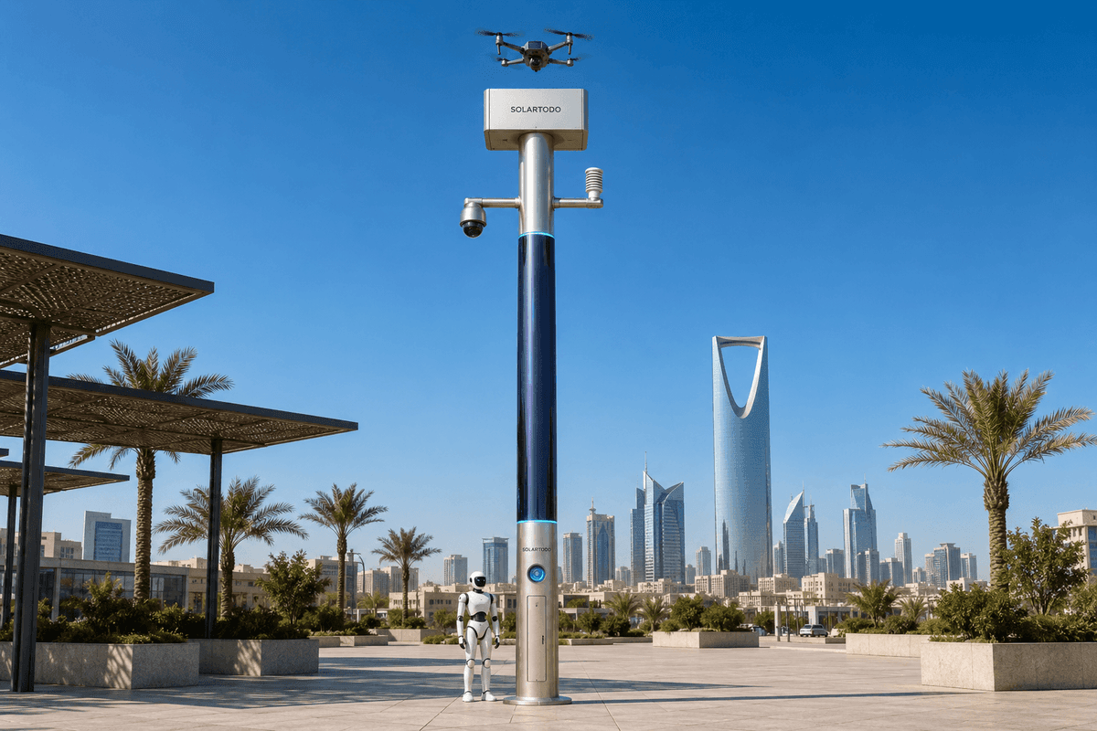
A City AI Pole is a non-lighting physical-AI edge node that combines off-grid energy, local compute, sensing, drone operations and robot operations in one urban pole. This Kuwait City Sentinel Sky Hub configuration supports flood-control patrols by processing PTZ camera and environmental data locally and coordinating field response through a human-authorized command view.
1. Operating Context: Flood Control Under Event Pressure
Kuwait City’s water-authority operating problem is not routine observation; it is continuity during fast-moving rain events when drainage corridors, underpasses, waterfront access roads, event venues and city-edge service routes can all require attention at the same time. In the proposed deployment, SOLARTODO Sentinel Sky Hub poles are placed as a grid-mesh of physical-AI edge nodes around flood-control assets serving sports-event districts, car-park approaches, coastal promenades, low-lying access roads and city perimeter drainage interfaces. The planning archetype is mountain: not because Kuwait City is a mountain city, but because the operating model treats upstream-to-downstream runoff paths, elevated approach roads, embankments and low-point basins as a vertical risk chain that must be watched as one system. During seasonal sports events, that chain becomes more sensitive. A blocked drain near an approach road may slow emergency access, a flooded pedestrian underpass may affect crowd safety, and a telecom outage can remove the very visibility needed by dispatchers. The goal is therefore an operations plan, not a hardware showcase: keep patrol frequency high when network quality drops, reduce dependence on manual drive-by checks, and give the water authority a common-operating-picture command view that still works when remote connectivity is degraded. Each Sky Hub is proposed as a pure smart pole with no lighting system, no grid dependency and no city or site power feed. The pole combines battery storage with 360-degree wrapped flexible CIGS thin-film solar replenishment, so it behaves as a fully off-grid, battery-backed micro-station. Solar is treated honestly as replenishment, not as unlimited self-sufficiency. The edge node’s main job is to observe, decide what matters locally, queue authorized response options and document the patrol record.
2. Grid-Mesh Deployment Mode for Network-Outage Resilience
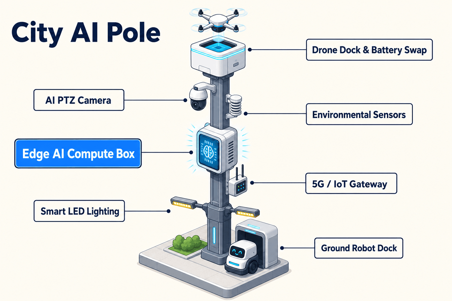
The proposed Kuwait City layout uses a grid-mesh deployment pattern rather than isolated single poles. Nodes are positioned so that critical flood-control points are covered by overlapping operational cells: a PTZ camera view cell, an environmental sensor cell, a drone sortie cell and a ground robot return-and-charge cell. The mesh is designed for graceful degradation. If the wide-area network is disrupted during heavy rain or sports-event congestion, each pole continues local inference, local event logging, local workload scheduling and patrol task execution. Only de-identified event and status metadata is designed to leave the pole; raw video and sensor data stay on the pole and are processed locally. That approach supports PDPL/LGPD-oriented data handling by reducing centralized raw-data movement while still allowing authorized supervisors to see incident summaries, confidence levels, asset health and mission status in the COP. The PTZ camera is the module focus because the water authority’s practical need is not just to know that rain occurred; it needs visual confirmation of ponding, blocked inlets, unsafe water depth indicators, flow direction changes and crowd-adjacent obstruction. The PTZ patrol pattern is scheduled by edge compute so the camera can scan high-priority drainage assets more often during event ingress, halftime or closing waves, then return to a normal cadence after the risk window. Anonymous vehicle count and crowd density can be used to prioritize flood-control response near event routes without activating face or licence-plate recognition. A node can also accept optional partner-sensor inputs, including external radar where separately deployed, but radar is not treated as built-in pole hardware. The mesh’s KPI framing is patrol frequency: how many reliable inspections of priority flood-control points can be scheduled, executed and recorded per hour or per event window, especially when network connectivity is poor.
3. Edge-Computing Ops Plan: Sensing to Authorized Response
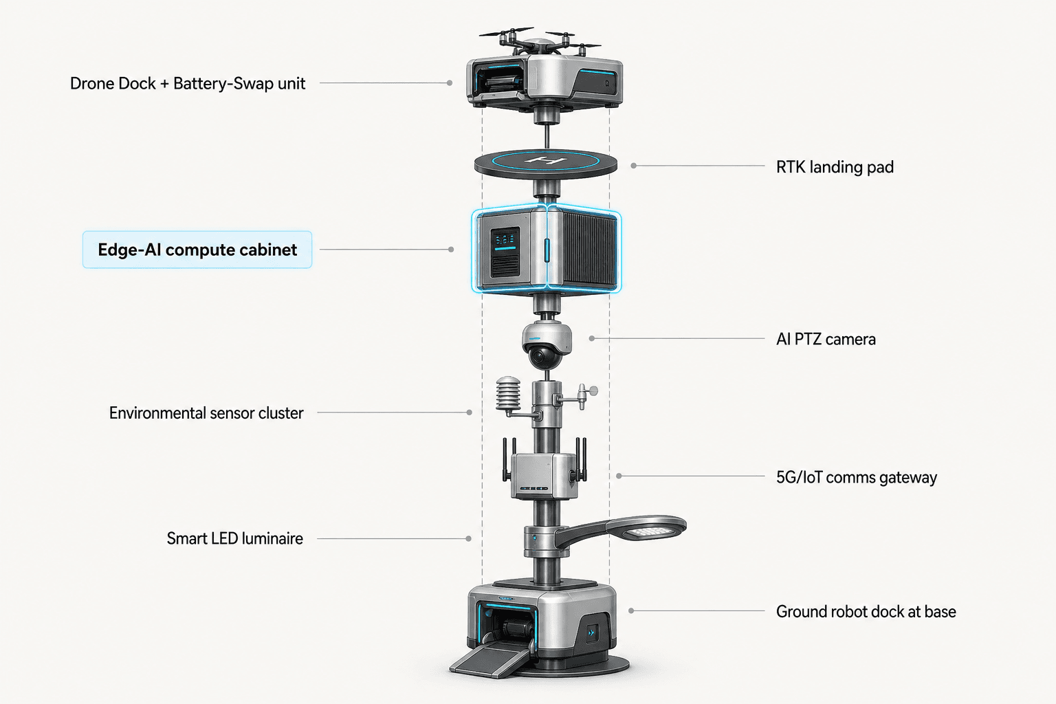
In the proposed operating loop, each Sentinel Sky Hub performs sensing, authorized assessment and response, edge-compute scheduling, and field operations and maintenance as one coordinated workflow. The PTZ camera and environmental sensors collect local signals: wind speed, wind direction, temperature, humidity, atmospheric pressure, noise, PM10, PM2.5 and illuminance. On-pole inference classifies relevant conditions such as rising water presence, unusual crowd clustering near a flood-prone access point, vehicle congestion around a drainage route, intrusion into restricted pump or drainage zones, and perimeter anomalies near critical infrastructure. Because raw data stays on the pole, the COP receives de-identified metadata such as event type, location reference, confidence score, patrol status and recommended response option. Human authorization remains central. When the system detects a flood-control anomaly, the water-authority operator can authorize a closer PTZ sweep, dispatch a drone sortie, send a ground robot to inspect a nearby inlet or create a maintenance ticket. Drone operations include launch, regional patrol, inspection, return and task redeployment without an operator on site. The battery hot-swap magazine performs automated rear-service battery exchange after landing, allowing several consecutive sorties depending on duty cycle, weather and battery-state planning. Ground robot operations support autonomous patrol, alarm response, inspection, air-ground coordination and return to the pole base for wireless charging. Counter-UAS coordination remains narrow and non-lethal: if an unauthorized drone is detected and tracked, the node may command its own friendly drone for human-authorized soft aerial net-capture or close-approach deterrence. It does not perform shoot-downs, jamming, denial or autonomous attack. This keeps the flood-control mission focused on continuity, inspection and controlled escalation rather than open-ended automation.
4. Off-Grid Energy and Duty-Cycle Planning
For Kuwait City, off-grid energy is treated as an engineering constraint that shapes the patrol plan. A Sky Hub pole carries approximately 15 square meters of 360-degree wrapped flexible CIGS thin-film over a vertical cylindrical body around 8 meters tall and 0.6 meters wide, with roughly 2.4 to 2.7 kWp nameplate. Because a vertical cylinder collects direct sun mainly on its sun-facing projection, not the full wrap at once, realistic clear-sky production in high-irradiance regions is planned around roughly 0.8 to 1.1 kW DC peak, typically peaking in the mid-morning or afternoon rather than exactly at noon, and around 6 to 9 kWh per day. The CIGS layer is therefore a supplemental replenishment layer for a fully off-grid, battery-backed micro-station. High-power drone and robot tasks are buffered by 5 to 20 kWh-class storage and scheduled by duty cycle. The water authority can configure patrol frequency by risk window. During a sports-event rain forecast, the system may reserve energy for extra PTZ sweeps, pre-event drone inspection, post-event drainage checks and robot response at known low points. During normal days, it can maintain a lower inspection cadence and rebuild reserve. Edge-compute scheduling helps balance workloads on-pole: local inference, PTZ movement, environmental sensing, drone battery exchange, robot charging and metadata transmission are treated as competing loads. This is important for B2B credibility. The proposal does not claim unlimited pure-solar operation; it claims a fully off-grid architecture that uses storage, solar replenishment, mission scheduling and operational thresholds to sustain field coverage without depending on grid, city or site power.
5. Evaluation Plan for the Water Authority
The deployment should be evaluated as an operations program with clear acceptance criteria subject to final engineering confirmation. The first metric is patrol frequency: target inspections per priority flood-control point during normal periods, event periods and network-outage periods. The second is patrol continuity: whether the node keeps scanning, logging and queuing response options when backhaul is degraded. The third is response readiness: whether authorized operators can launch a drone patrol, redeploy a task after battery hot-swap, or send a ground robot for local inspection without placing personnel into unsafe flooded areas. The fourth is evidence quality: each event record should show what was detected, what the edge model classified, which operator authorization was given, what field action occurred and what status metadata was retained. The fifth is privacy orientation: raw video and sensor streams stay on the pole, while only de-identified event and status metadata may leave the site. In procurement terms, this positions Sentinel Sky Hub as a city-ai-pole category system for flood-control continuity, not a general urban fixture and not a lighting asset. For Kuwait City, the proposed first use case is a water-authority grid-mesh around event-sensitive drainage corridors where network outage is the core pain point and PTZ-driven patrol frequency is the operational KPI. The most useful buying decision is not how many poles to announce, but which flood-control points must remain visible when human patrols, connectivity and event traffic are all under pressure at once.
System Configuration
| Parameter | Configuration |
|---|---|
| Pole type | Pure smart pole physical-AI edge node with no lighting system; fully off-grid battery-backed micro-station |
| Energy system | ~15 m² 360° wrapped flexible CIGS thin-film replenishment, ~2.4-2.7 kWp nameplate, planned around ~0.8-1.1 kW DC clear-sky peak and ~6-9 kWh/day in high-irradiance conditions |
| Battery storage | 5-20 kWh-class storage sized by patrol duty cycle, drone sorties, robot charging and outage reserve |
| Edge AI compute | Jetson-class on-pole inference and workload scheduler for local video, sensor and mission-state processing |
| Camera | AI PTZ camera for scheduled 360° patrols, anonymous vehicle count, crowd density, intrusion and perimeter awareness |
| Autonomous operations | Drone launch, inspection, return, automated multi-bay battery hot-swap, task redeployment and ground robot wireless charging at pole base |
| Data handling | Raw video and sensor data processed locally on the pole; only de-identified event and status metadata may leave the site |
How It Works
- On-pole PTZ patrol scans flood-control points and flags water, obstruction or perimeter anomalies.
- Edge AI classifies the event locally and assigns a confidence score without sending raw video off the pole.
- The COP presents de-identified event metadata, pole health and recommended response options to an authorized operator.
- The operator approves a closer PTZ sweep, drone sortie, ground robot inspection or maintenance dispatch.
- The node schedules energy, battery swap, robot charging and mission tasks, then records the action log locally and shares status metadata.
Planning Assumptions (Indicative)
Illustrative planning inputs a buyer can recompute — target metrics, not achieved results. Subject to final engineering confirmation.
| Metric | Planning assumption | Indicative value |
|---|---|---|
| Patrol frequency | Priority flood-control points receive scheduled PTZ inspections during event windows instead of waiting for manual drive-by checks | ~4-6 inspections/hour per priority point targeted |
| Manual exposure | Drone or ground robot inspection replaces selected staff visits to flooded or traffic-constrained access points | ~10-20 field visits/week avoided as a planning input |
| Outage continuity | Local inference and event logging continue when wide-area connectivity is degraded | ~8-12 hours local-first operation target, subject to storage sizing |
| Drone sortie cadence | Battery hot-swap magazine supports consecutive short inspection missions when reserve thresholds permit | ~3-5 sorties/event window planned |
| Operator workload | COP receives classified event/status metadata rather than continuous raw feeds for every pole | ~1 exception queue per zone targeted |
Deployed Equipment
- SOLARTODO Sentinel Sky Hub pure smart pole body
- 360° wrapped flexible CIGS thin-film solar replenishment layer
- 5-20 kWh-class battery storage cabinet
- AI PTZ camera with local perception pipeline
- Nine-parameter environmental monitoring package
- On-pole Jetson-class edge AI compute module
- Autonomous drone bay with multi-bay battery hot-swap magazine
- Ground robot wireless charging base integrated at the pole foot
Frequently Asked Questions
Is Sky Hub a smart streetlight or a lighting retrofit?
No. In this proposed Kuwait City configuration, Sky Hub is a pure smart pole physical-AI edge node with no lighting system. Its purpose is flood-control sensing, local edge processing, autonomous drone operations, ground robot operations, energy buffering and command-view coordination for the water authority.
How does the system help during a network outage?
Each node is designed to keep operating locally when backhaul is degraded. The PTZ camera, environmental sensors, edge inference, mission queue, event log and workload scheduler remain on the pole. The command view can receive de-identified status metadata when links are available, while raw video and sensor data stay local.
Why is patrol frequency the main KPI for this case?
Flood-control teams need repeated checks of priority low points, drainage assets and access routes during rain and sports-event traffic. Patrol frequency is a practical KPI because it measures whether the authority can maintain inspection cadence despite congestion, weather, reduced staff access or temporary network disruption.
Does the off-grid solar wrap make the pole energy-unlimited?
No. The wrapped CIGS layer is a replenishment source for a battery-backed micro-station, not a promise of unlimited pure-solar operation. Planning should use realistic clear-sky output of roughly 0.8 to 1.1 kW DC peak and about 6 to 9 kWh per day in high-irradiance conditions, then schedule drone and robot duty cycles against storage.
What data leaves the pole?
The proposed data architecture is local-first and PDPL/LGPD-oriented. Raw video and sensor data are processed and retained on the pole according to the buyer’s retention policy. Only de-identified event and status metadata, such as anomaly type, confidence, pole health and mission state, may leave the site.
How is Counter-UAS handled in a flood-control deployment?
Counter-UAS coordination is limited to detection, tracking and human-authorized non-lethal response. The node may command a friendly drone for soft aerial net-capture or close-approach deterrence where policy permits. It does not use shoot-down, jamming, denial, weapons or autonomous attack workflows.
Explore Further
- City AI Pole / smart streetlight product line
- More smart-city deployment cases
- Talk to our engineering team
Planning a similar physical-AI deployment for streets, campuses or public spaces? Request an engineering consultation