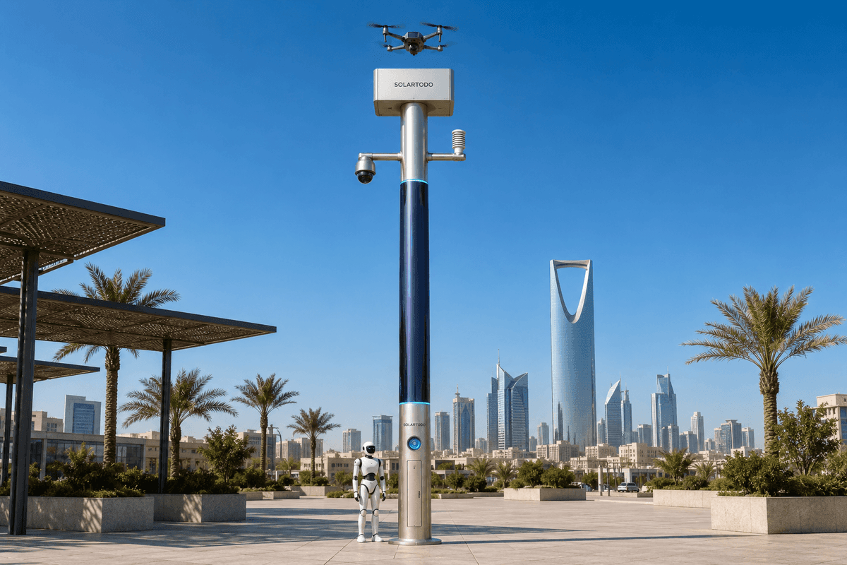
A City AI Pole is a non-lighting physical-AI edge node that combines sensing, edge compute, off-grid energy storage, drone operations, robot operations, and command coordination in one pole-form micro-station. In Casablanca, the proposed Sentinel Sky Hub configuration supports river-cross-section monitoring for industrial-park eco-environment teams, using local PTZ perception and authorized drone inspection without exporting raw data.
1. Casablanca Task Context: Holiday Night Response Around Industrial Water Cross-Sections
This proposed pilot-report configuration is framed for an eco-environment stakeholder responsible for night inspection around an industrial-park edge in Casablanca, Morocco. The operating area is not a general city beautification corridor or a lighting project. It is a practical low-altitude inspection zone: river-cross-section monitoring points, drainage-side access roads, perimeter edges, service yards, small bridges, and the interfaces between industrial activity and receiving water paths.
The seasonal trigger is the holiday period. During holidays, industrial sites may operate with reduced supervision, contractors rotate, waste movement changes, and response teams can be thinner at night. The core pain point is not that the city lacks sensors; it is that an abnormal condition seen after dark can sit in a gap between fixed camera review, manual dispatch, and a patrol team physically reaching the cross-section. For eco-environment operations, that delay can matter when an odor complaint, visible discharge, blocked channel, trespass near a monitoring point, or suspicious vehicle movement requires a documented first look.
The KPI framing is patrol frequency. The buyer should evaluate whether the system increases scheduled and exception-driven inspection passes per night without requiring an operator to stand beside the pole, and whether each pass produces a structured event record that can be reviewed in a common-operating-picture command view. The pilot does not claim achieved detection rates, coverage area, or response latency. Those values should be confirmed through site engineering, route design, local radio assessment, and the city’s own operating rules.
The selected deployment mode is river-cross-section. Instead of scattering nodes generically, the proposed layout places Sky Hub poles where a PTZ camera can observe the cross-section approach, the channel edge, nearby access points, and vehicle or crowd patterns that may indicate an incident. The pole then becomes an off-grid inspection micro-station that can cue a drone for low-altitude visual confirmation and, where appropriate, coordinate a ground robot response from the base zone.
2. Proposed Node Configuration: PTZ-Led Edge Awareness, Drone-First Inspection
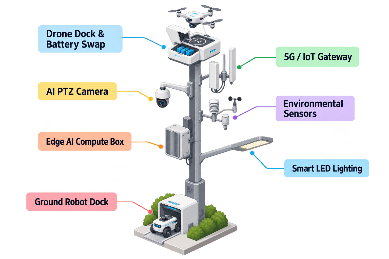
The proposed Casablanca node is a SOLARTODO Sentinel Sky Hub: a mature pole-form physical-AI edge node running OTATODO at the edge. It is a pure smart pole with no lighting system. Its purpose in this case is not illumination, but the operation of sensing, compute, energy, drone, and robot workflows at an industrial-park river-cross-section.
The module focus is the PTZ camera. The PTZ provides active observation across the cross-section, service road, channel bank, and perimeter line. Local perception supports anonymous vehicle count, crowd density, intrusion, and perimeter awareness. It is not presented as a personal identification system and does not rely on active deployed face or licence-plate recognition. The operational value is that the PTZ can watch the right places, classify an anomaly locally, and create a de-identified event that is meaningful enough for an eco-environment operator to decide whether to send the node’s drone.
Once authorized, the drone workflow supports launch, low-altitude inspection, return, and task redeployment without an operator standing on site. A rear-service multi-bay battery magazine performs automated hot-swap after landing: the aircraft receives a charged pack, and the system can prepare a further sortie if the duty cycle and battery state allow. The management layer handles route planning, task queueing, charge and swap state, fleet health, and mission logs. This is especially relevant during holidays, when a single night operator may need to supervise multiple cross-section events from a central command view.
The ground robot workflow is secondary in this pilot narrative but remains part of the node’s integrated capability set. A humanoid or service robot can perform autonomous patrol, alarm response, inspection at the pole base area, and air-ground coordination, then return for wireless charging. In a river-cross-section use case, that means the drone can inspect from above while the robot checks the accessible bank, fence line, or service bay, subject to local safety rules and route confirmation.
3. Off-Grid Energy and Local Data Handling: Practical, Not Unlimited
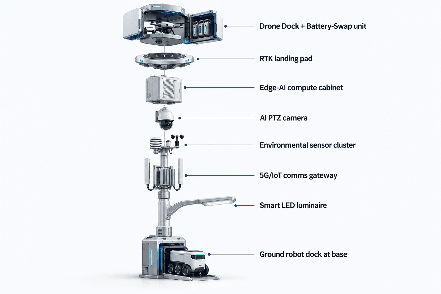
The proposed Sky Hub node is fully off-grid: it does not depend on city, grid, or site power. The energy architecture is a battery-backed micro-station with on-pole solar replenishment. The pole carries about 15 m² of 360-degree wrapped flexible CIGS thin-film solar over a vertical cylindrical body roughly 8 m tall and about 0.6 m wide, with a nameplate range around 2.4 to 2.7 kWp.
The planning model must stay realistic. A vertical cylinder does not collect full-wrap direct sun at once; it collects direct sun primarily on its sun-facing projection. In a high-irradiance benchmark region such as Saudi Arabia, a clear-sky output expectation is roughly 0.8 to 1.1 kW DC peak, usually peaking in the mid-morning or mid-afternoon rather than at noon, with about 6 to 9 kWh per day. Casablanca’s final yield should be confirmed by local solar assessment, shading study, seasonal weather profile, mounting geometry, and actual duty cycle.
For this reason, the CIGS layer should be understood as supplemental replenishment for a fully off-grid, battery-backed node, not as an unlimited pure-solar claim. High-power drone and robot tasks are buffered by 5 to 20 kWh-class storage and scheduled by duty cycle. During a holiday night-response period, the command view should prioritize patrol frequency, battery state, drone readiness, robot charge state, and energy budget together, rather than treating each sortie as isolated.
Data handling follows the same practical discipline. Raw video and sensor data stay on the pole and are processed locally by a Jetson-class edge module, using Orin- or Thor-class compute depending on the selected configuration. Only de-identified event and status metadata may leave the pole. The architecture is PDPL/LGPD-oriented because it is designed for local processing, minimization, and auditability, but final legal compliance, data retention policy, signage, procurement language, and operational authorization remain subject to buyer review and local counsel.
4. Operations Loop: From PTZ Anomaly to Authorized Low-Altitude Inspection
The daily operating pattern follows one command loop: sensing, authorized assessment and response, edge-compute scheduling, and field operations and maintenance. In the common-operating-picture view, the eco-environment team does not need to watch raw continuous feeds from every pole. The system should surface cross-section status, PTZ event cards, drone readiness, battery state, environmental readings, and mission logs as structured operational metadata.
A typical holiday-night event begins when the PTZ camera flags an anomaly: unusual vehicle dwell time near the channel, movement in a restricted service area, crowding at a perimeter edge, a possible obstruction, or visual evidence that a discharge point needs closer inspection. OTATODO schedules local inference on the pole and scores the event. The event is then presented to the operator with location, time, confidence category, camera snapshot policy as configured, battery status, and recommended inspection path. The operator authorizes response according to the city’s rules.
After authorization, the drone launches for a low-altitude inspection route. It may follow a short cross-section pass, a channel-edge pass, or a perimeter loop, depending on the task queue and weather state. The mission can be redeployed if the PTZ continues to see activity or if the environmental sensor package indicates conditions worth checking. After landing, the hot-swap magazine can exchange the battery and return the drone to readiness for another sortie, subject to energy scheduling.
Environmental monitoring adds context, not clutter. The nine-in-one package measures wind speed, wind direction, temperature, humidity, atmospheric pressure, noise, PM10, PM2.5, and illuminance. Wind readings influence whether a drone sortie should proceed. Particulate, noise, and basic weather readings help operators interpret complaints or nighttime anomalies. Illuminance is treated as an environmental value, not a lighting function.
Counter-UAS coordination remains tightly bounded. If an unauthorized drone appears near the industrial-park cross-section, the pole can detect and track it through its available sensing inputs and can command the node’s friendly drone for a human-authorized, non-kinetic response such as soft aerial net-capture or close-approach deterrence. Radar is not pole hardware; it may only be treated as an optional partner-sensor input if the buyer integrates it. No shoot-down, jamming, denial, autonomous attack, or weaponized response is part of this configuration.
5. Evaluation Plan: Patrol-Frequency Targets Subject to Engineering Confirmation
For the Casablanca buyer, the value of the proposed pilot should be evaluated through patrol-frequency and response-readiness metrics rather than a generic technology checklist. The planning question is simple: can the eco-environment team increase night inspection passes around priority river-cross-sections during holidays while keeping raw data local, maintaining off-grid operation, and preserving human authorization over regulated actions?
The evaluation should separate scheduled patrols from event-driven patrols. Scheduled patrols are planned drone inspection passes at defined times, such as the start of the night shift, mid-shift, and pre-dawn. Event-driven patrols are launched after PTZ or environmental triggers. A useful pilot design may compare manual-only holiday coverage with an assisted model where the Sky Hub node provides recurring PTZ scans, drone readiness, and structured event logs. The numbers should be treated as target planning inputs until verified on site.
The pilot should also track operational discipline. Every event should produce a mission log, decision record, battery state record, and maintenance status. If a drone is not launched because of wind, energy state, or authorization status, that should also be recorded. This makes the system more useful to eco-environment managers: they can see not only what happened, but why the node acted or did not act.
A practical acceptance review would confirm PTZ field of view, solar exposure, safe drone corridors, robot base access, communications quality, data retention policy, COP roles, and holiday staffing procedures. With those conditions confirmed, SOLARTODO Sentinel Sky Hub can be evaluated as a physical-AI edge-node layer for Casablanca’s industrial-park river-cross-section monitoring: off-grid, locally processed, drone-ready, robot-ready, and designed around patrol frequency rather than speculative automation claims.
System Configuration
| Parameter | Configuration |
|---|---|
| Deployment archetype | Industrial-park river-cross-section node for eco-environment night-response monitoring |
| Pole platform | SOLARTODO Sentinel Sky Hub pure smart pole, non-lighting, fully off-grid |
| Camera | AI PTZ camera for 360-degree patrol views, anonymous vehicle count, crowd density, intrusion and perimeter awareness |
| Edge AI compute | Jetson-class on-pole inference module, Orin- or Thor-class configuration subject to final engineering confirmation |
| Energy system | 5-20 kWh-class battery storage plus about 15 m² 360-degree wrapped flexible CIGS replenishment, about 2.4-2.7 kWp nameplate |
| Drone operations | Autonomous launch, low-altitude inspection route, return, multi-bay rear-service battery hot-swap, task redeployment |
| Data policy | Raw video and sensor data processed on the pole; only de-identified event and status metadata may leave the node |
How It Works
- PTZ camera patrols the river-cross-section and flags a night anomaly locally.
- Edge AI classifies the event, scores priority, and keeps raw video on the pole.
- COP presents de-identified event metadata, battery state, weather state, and recommended inspection route to an authorized operator.
- Operator approves drone inspection or holds the task according to local rules and safety conditions.
- Drone performs the low-altitude cross-section pass, returns to the pole, and receives battery hot-swap if another sortie is queued.
- OTATODO records the decision, mission log, environmental context, energy state, and maintenance status for review.
Planning Assumptions (Indicative)
Illustrative planning inputs a buyer can recompute — target metrics, not achieved results. Subject to final engineering confirmation.
| Metric | Planning assumption | Indicative value |
|---|---|---|
| Night patrol frequency | Target model compares manual-only holiday inspection with scheduled plus event-driven drone patrols | ~3-6 cross-section patrol opportunities per night per node |
| Manual dispatch screening | PTZ-led local event scoring screens routine anomalies before a field team is sent | ~30-50% of low-priority checks reviewed remotely first |
| Drone readiness | Multi-bay battery hot-swap supports consecutive sorties within the site duty cycle | ~2-4 short inspection sorties before maintenance review |
| Energy budgeting | Battery storage buffers high-power drone and robot tasks while CIGS replenishes during daylight | 5-20 kWh storage class, duty-cycle scheduled |
| Event documentation | Each authorized inspection generates a decision record, mission log, battery state, and de-identified event metadata | 100% of triggered tasks targeted for structured logging |
Deployed Equipment
- SOLARTODO Sentinel Sky Hub pole body with 360-degree wrapped flexible CIGS layer
- Battery-backed off-grid power cabinet
- AI PTZ camera package
- Jetson-class edge AI compute cabinet
- Nine-in-one environmental sensor package
- Autonomous drone bay with multi-bay rear-service battery hot-swap magazine
- Wireless charging base interface for humanoid or service robot
- COP command-view software running OTATODO event, mission, and health workflows
Frequently Asked Questions
Is this a completed Casablanca rollout with measured results?
No. This is a proposed and illustrative pilot-report configuration for a Casablanca industrial-park river-cross-section scenario. Patrol frequency, sortie counts, screening ratios, and documentation targets are planning assumptions that a buyer can recompute. Final quantities, routes, coverage, and performance values require site survey, engineering confirmation, and operating-rule approval.
Why is the PTZ camera the lead module in this scenario?
The pain point is holiday night response, where the first operational need is to see whether a cross-section anomaly deserves inspection. A PTZ camera with local perception can patrol the channel edge, service road, and perimeter approaches, then create a de-identified event for operator review before a drone sortie is authorized.
How does the drone workflow help the eco-environment team?
The drone provides a fast low-altitude inspection pass when the operator authorizes it, especially when manual access is slow, staffing is reduced, or the cross-section is difficult to inspect after dark. The hot-swap magazine keeps the aircraft ready for consecutive short sorties, while mission logs document what was inspected and why.
Does the pole require grid, city, or site power?
No. The proposed Sky Hub configuration is designed as a fully off-grid battery-backed micro-station. The wrapped flexible CIGS layer provides supplemental replenishment, while 5-20 kWh-class storage buffers drone, robot, sensing, compute, and communications loads. Final duty cycle must be engineered against local solar yield and mission frequency.
What data leaves the pole during operation?
By default, raw video and sensor data stay on the pole for local processing. The command view receives de-identified event and status metadata, such as event type, time, node health, energy state, weather context, and mission log entries. This supports a PDPL/LGPD-oriented architecture without claiming certification or final legal compliance.
Can the system handle unauthorized drones near the site?
The node can support detection, tracking, and human-authorized coordination with its own friendly drone for non-kinetic measures such as soft aerial net-capture or close-approach deterrence. It is not a shoot-down, jamming, denial, autonomous attack, or weapons system. Radar, if used, is only an optional partner-sensor input.
What should the buyer verify before approving a pilot?
The buyer should verify PTZ sightlines, safe drone routes, local aviation permissions, cross-section access rules, solar exposure, battery duty cycle, communications quality, robot path safety, data retention policy, signage requirements, and COP authorization roles. These checks turn the illustrative configuration into an engineered deployment plan.
Explore Further
- City AI Pole / smart streetlight product line
- More smart-city deployment cases
- Talk to our engineering team
Planning a similar physical-AI deployment for streets, campuses or public spaces? Request an engineering consultation