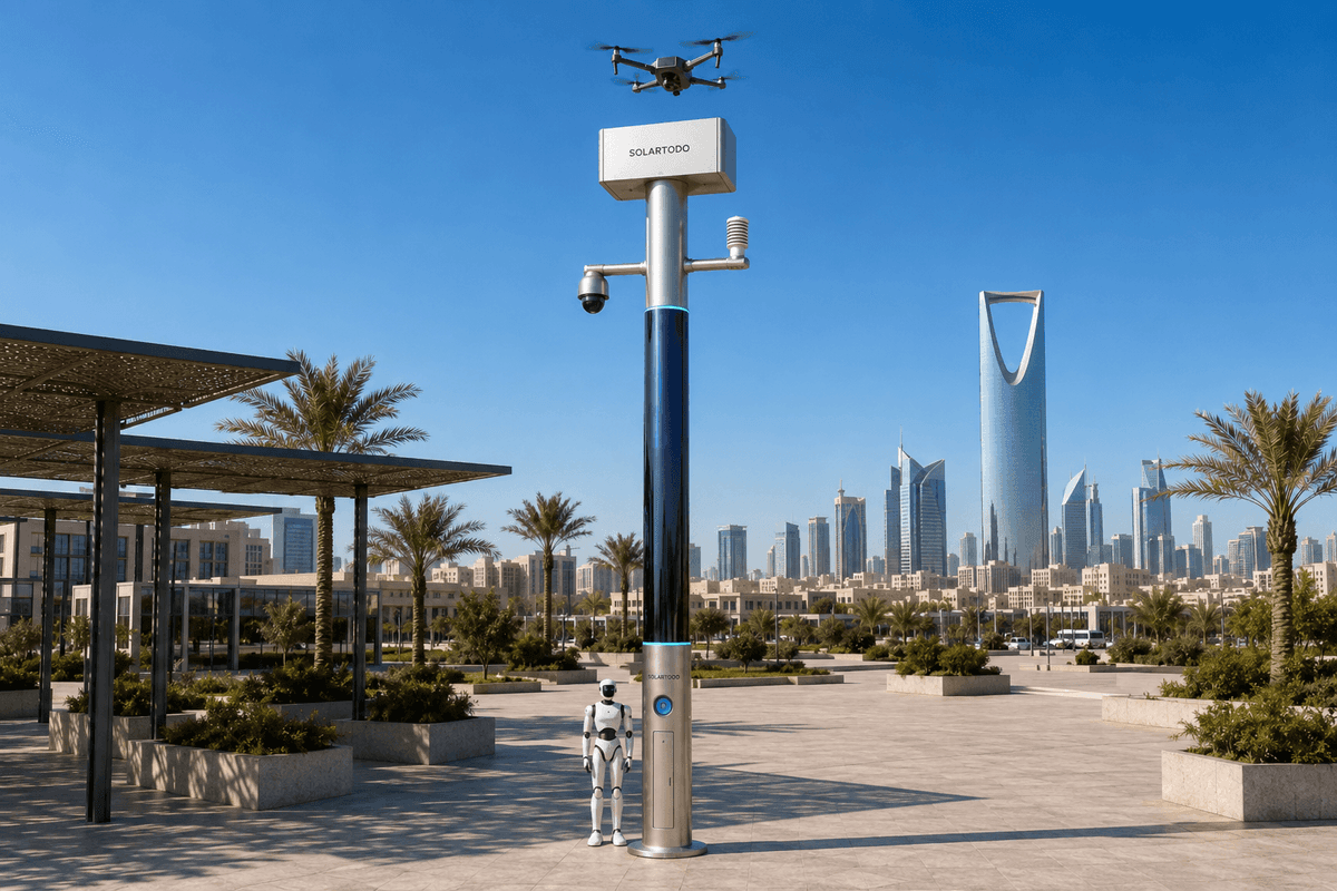
A City AI Pole is a non-lighting physical-AI edge node that hosts sensing, compute, energy storage, drone operations and ground robot coordination at the site edge. In this Bangkok configuration, SOLARTODO Sentinel Sky Hub monitors a transport-hub campus perimeter, processes raw data locally, dispatches low-altitude inspection sorties and shares only de-identified event or status metadata.
Incident Context
Bangkok's transport hubs do not go quiet after office hours. During night-economy seasons, station plazas, pickup lanes, food-service edges, canal-side walkways and parking perimeters can remain active long after the formal commuter peak. For an eco-environment stakeholder, the operational problem is not only safety. It is also whether service yards, drainage edges, waste-transfer corners, landscaped buffers and restricted utility zones are being inspected with enough precision to distinguish normal night movement from an environmental or perimeter anomaly. This proposed case study uses a transport-hub campus perimeter in Bangkok as the planning setting, subject to final engineering confirmation. The pain point is blind spots: bends behind service buildings, short access roads beside drainage channels, temporary vendor clusters, parked vehicles blocking fixed views and humid-night glare that can make a static camera event look more severe than it is. Traditional patrol review often creates two bad outcomes. Operators receive too many ambiguous alerts, or they wait for a person to walk the perimeter before deciding whether an alert is real. In a night-economy context, both outcomes matter. A false intrusion alarm can pull staff away from sanitation, traffic flow or crowd-support tasks. A missed low-altitude inspection task can leave illegal dumping, blocked drainage, smoke, odor, unauthorized access or equipment damage unverified until the morning. SOLARTODO Sentinel Sky Hub is positioned here as a city-ai-pole / physical-AI urban edge node, not as a smart streetlight and not as public illumination infrastructure. The task is to support low-altitude inspection around the campus perimeter with a PTZ-led detection loop, locally processed evidence and drone redeployment for visual confirmation. The article does not claim a live Bangkok customer, achieved detection rates, named government adoption or certified regulatory status. It defines an illustrative configuration and evaluation method for a buyer to recompute.
Incident Review Method
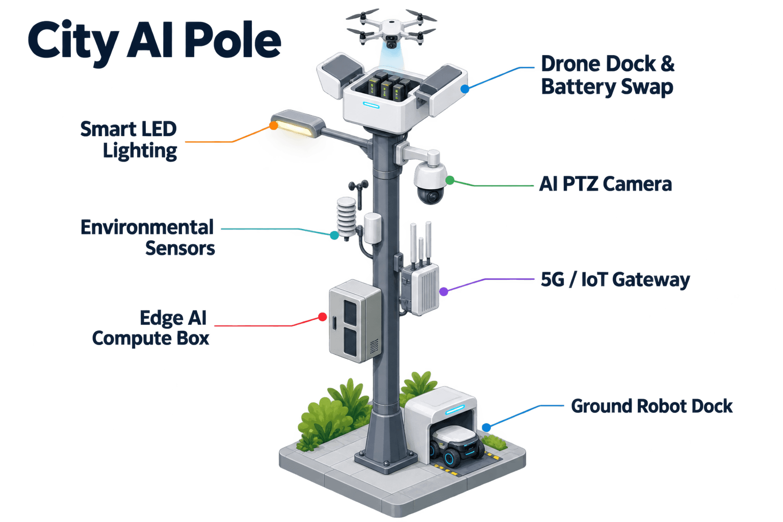
The review begins with an incident type that Bangkok transport-hub operators already recognize: an after-dark perimeter alert near a service gate during a busy evening. The PTZ camera detects motion and unusual dwell time near an eco-environment asset, such as a drainage inspection point, equipment cabinet or waste-handling lane. Instead of sending raw video away from the site, the pole's edge module scores the local scene for anonymous vehicle count, crowd density, intrusion and perimeter awareness. It does not activate face recognition or licence-plate recognition as a deployed capability in this configuration. The operational question is whether the alert should become a field response, a drone inspection task, a robot patrol task or a logged low-priority event. Sky Hub supports the loop known internally as sensing, authorized assessment/response, edge-compute scheduling and field operations and maintenance, presented to operators as a single common-operating-picture command view. In practical terms, the COP shows the incident location, PTZ snapshot metadata, environmental sensor context, drone charge or swap state, robot availability, task queue and mission log. Human authorization remains part of the decision point when the response affects people, vehicles or regulated airspace. For the low-altitude-inspection scenario, the recommended first action is usually a short drone sortie along the perimeter segment, not a manual dispatch. The drone launches from the pole, follows a planned inspection route, returns to the node and, when required, receives an automated rear-service battery exchange through the multi-bay magazine. Several consecutive sorties can be planned by duty cycle because energy is buffered by storage and managed by OTATODO at the edge. The purpose is to reduce the false-alarm rate by giving operators richer local confirmation before a field team is sent. The KPI is framed as an evaluation metric: how many PTZ-triggered anomalies are cleared, escalated or reclassified after local edge scoring plus low-altitude inspection, compared with the buyer's baseline process.
Node Configuration
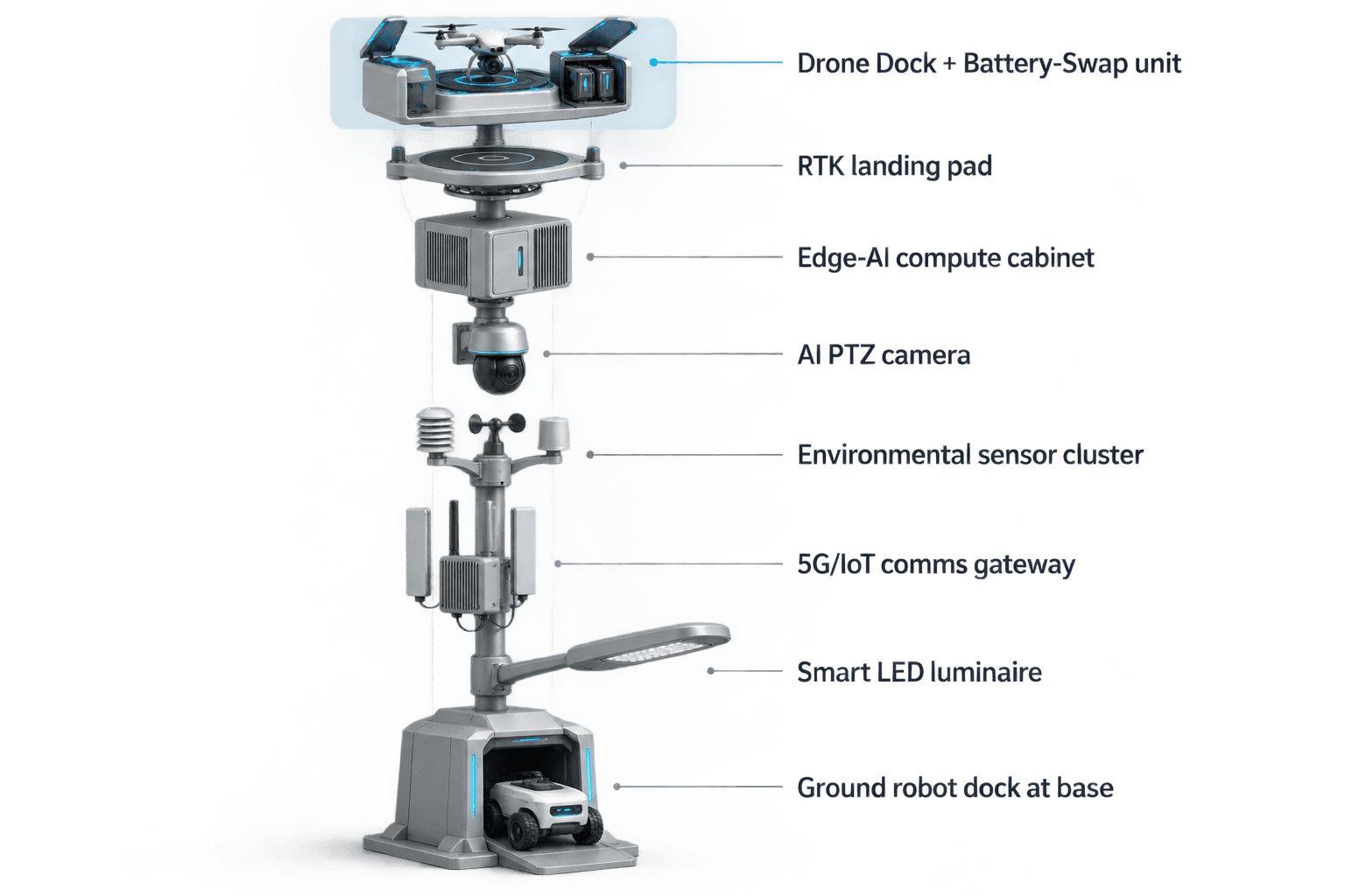
The proposed Sky Hub node is a pure smart pole: a non-lighting intelligent pole hosting sensing, compute, energy, drone and robot operations. Its body uses roughly 15 square meters of 360-degree-wrapped flexible CIGS thin-film on a vertical cylindrical surface about 8 meters tall and about 0.6 meters wide. The nameplate range is about 2.4 to 2.7 kWp, but the planning assumption must respect geometry. A vertical cylinder does not collect direct sun across the entire wrap at once. In a high-irradiance reference region, realistic clear-sky output is roughly 0.8 to 1.1 kW DC peak, typically peaking mid-morning or mid-afternoon rather than at noon, and about 6 to 9 kWh per day. Bangkok engineering should adjust this with local weather, shading, monsoon season, dirt, maintenance access and site geometry. The solar skin is a supplemental replenishment layer for a fully off-grid, battery-backed micro-station. It should not be sold as unlimited pure-solar self-sufficiency. High-power drone and robot tasks are buffered by 5 to 20 kWh-class storage and scheduled by duty cycle. The PTZ camera is the focus module for this deployment because the main pain point is blind spots. A PTZ can patrol the perimeter, revisit flagged zones, hand off a target area to the drone route planner and provide context before a human approves response. Environmental monitoring adds wind speed, wind direction, temperature, humidity, atmospheric pressure, noise, PM10, PM2.5 and illuminance so that an alert can be interpreted with local conditions. A Jetson-class edge module, in an Orin- or Thor-class performance band, runs on-pole inference and workload scheduling. Raw video and sensor data stay on the pole for local processing; only de-identified event or status metadata may leave the pole. Data handling is designed for local processing and PDPL/LGPD-oriented review, not claimed as certified compliance.
Drone-Led Inspection
The primary topic in this Bangkok scenario is drone operations, because low-altitude inspection is the fastest way to turn a doubtful PTZ event into actionable context without sending staff into a crowded night perimeter. The node manages launch, regional patrol, inspection, return and task redeployment for autonomous sorties with no operator stationed at the pole. Drone operations management covers route planning, the charge or swap state machine, task queueing, fleet health and mission logs. When a drone lands, the multi-bay battery magazine performs an automated rear-service battery exchange so the aircraft receives a charged pack and can relaunch. Multiple bays allow several planned sorties, subject to weather, airspace permissions, site rules and final engineering confirmation. Ground robot operations support the same incident review but are secondary in this article. A humanoid or service robot can patrol the pole base zone, inspect reachable assets, coordinate with aerial inspection and return to the base for wireless charging. For example, after the drone confirms an object near a drainage grate, the robot can inspect the accessible ground path while the PTZ maintains visual context. Counter-UAS coordination is framed narrowly and safely. If an unauthorized drone is detected and tracked through local sensing or optional partner-sensor input, Sky Hub can command its own friendly drone for human-authorized soft aerial net-capture or close-approach deterrence. Radar is not built into the pole; any radar feed is an optional or partner-sensor input. This configuration does not use shoot-down, destructive action, jamming, denial or autonomous attack. For Bangkok transport-hub eco-environment operations, the same boundary is useful commercially: the system separates detection, decision support and authorized action, which helps buyers discuss operating rules before deployment rather than after a controversial incident.
KPI Evaluation
The KPI framing is false-alarm rate, not a claimed result. The buyer should set a baseline from existing PTZ, fixed-camera, guard-tour and incident-ticket records, then evaluate how many events are reclassified after local edge analysis and drone inspection. A practical review board can sort events into normal night-economy activity, environmental service issue, perimeter intrusion, maintenance fault, weather or visibility artifact, and unresolved. The value of Sky Hub is that the review package is produced at the edge: PTZ event score, local environmental context, drone mission log, battery or swap state, robot task status and the operator authorization record. Because raw video and raw sensor streams stay on the pole, the COP can be designed to show only what the operator needs for triage and audit. The proposed deployment mode is campus-perimeter: a small number of nodes can be placed at blind-spot-heavy edges rather than treating the whole transport district as one generic surveillance grid. Exact node count, spacing, coverage, route length, mounting foundation, aviation approval, weather hardening and maintenance interval must be confirmed through a site survey. The seasonal trigger is night economy, when crowds, vehicles, vendors and service work increase ambiguity. A credible evaluation should therefore compare similar evening periods, similar weather conditions and similar operating rules. The expected procurement conversation is not whether the pole replaces all people or all infrastructure. It is whether a fully off-grid physical-AI edge node can reduce unnecessary dispatches, improve inspection confidence and keep sensitive raw data local while supporting Bangkok's transport-hub environmental operations.
System Configuration
| Parameter | Configuration |
|---|---|
| Deployment category | City-ai-pole / physical-AI urban edge node for a Bangkok transport-hub campus perimeter; non-lighting, fully off-grid configuration |
| Camera | AI PTZ camera for 360-degree patrol patterns, blind-spot revisit, anonymous vehicle count, crowd density, intrusion and perimeter awareness |
| Edge AI compute | Jetson-class on-pole inference cabinet in an Orin- or Thor-class performance band; local workload scheduling under OTATODO |
| Drone operations | Autonomous launch, low-altitude inspection route, return, mission logging and rear-service battery hot-swap through a multi-bay magazine |
| Energy system | Fully off-grid battery-backed micro-station with 5-20 kWh-class storage and about 15 m2 of 360-degree flexible CIGS solar replenishment |
| Environmental monitoring | Wind speed, wind direction, temperature, humidity, atmospheric pressure, noise, PM10, PM2.5 and illuminance |
| Data handling | Raw video and sensor data processed locally on the pole; only de-identified event or status metadata leaves the node by policy |
How It Works
- On-pole PTZ camera flags a blind-spot anomaly along the transport-hub campus perimeter.
- Edge AI classifies the local scene and scores false-alarm risk using anonymous visual and environmental context.
- The COP presents the event package, drone readiness and recommended response for human authorization.
- An autonomous drone performs a low-altitude inspection route and returns to the Sky Hub node.
- OTATODO records the mission log, battery or swap state, operator decision and de-identified event metadata.
Planning Assumptions (Indicative)
Illustrative planning inputs a buyer can recompute — target metrics, not achieved results. Subject to final engineering confirmation.
| Metric | Planning assumption | Indicative value |
|---|---|---|
| False-alarm review | PTZ-triggered perimeter events are reclassified after edge scoring and drone inspection before dispatch | ~20-40 events/month reviewed against buyer baseline |
| Inspection labor | Drone patrol replaces routine manual night checks for predefined blind-spot segments | ~5-10 perimeter patrols/week automated |
| Escalation quality | Operators compare PTZ-only alerts with PTZ plus low-altitude inspection packages | ~3 event classes tracked: cleared, escalated, unresolved |
| Energy planning | High-power drone and robot tasks are scheduled around battery state and CIGS replenishment, not unlimited solar output | 5-20 kWh-class storage with duty-cycle limits |
| Privacy review | Raw video stays local while COP users receive de-identified event and status metadata | 100% of routine review packages designed as metadata-first |
Deployed Equipment
- SOLARTODO Sentinel Sky Hub pure smart pole body
- 360-degree wrapped flexible CIGS thin-film solar skin
- 5-20 kWh-class battery storage and power-management cabinet
- AI PTZ camera module
- Nine-parameter environmental sensor suite
- Jetson-class edge compute module running OTATODO
- Autonomous drone with rear-service battery hot-swap interface
- Ground service robot wireless charging interface
Frequently Asked Questions
Is SOLARTODO Sentinel Sky Hub a smart streetlight?
No. In this configuration Sky Hub is a pure smart pole and physical-AI city edge node, not a smart streetlight. It does not include a lighting system or public illumination role. The buyer should evaluate it as off-grid sensing, compute, drone operations, robot coordination and energy infrastructure for campus-perimeter tasks.
How does the Bangkok transport-hub scenario use drones without overclaiming results?
The proposed configuration uses the drone for low-altitude inspection after the PTZ camera and edge AI flag an ambiguous perimeter event. The article frames false-alarm reduction as a target evaluation metric, not an achieved result. Actual sortie length, airspace permissions, weather limits and operating rules require site survey and final engineering confirmation.
Does raw video leave the pole for cloud analytics?
No. The intended data pattern is local processing on the pole. Raw video and raw sensor data stay at the node, while only de-identified event or status metadata may leave the pole for the COP, audit trail or maintenance review. This is designed for local processing and PDPL/LGPD-oriented governance, not stated as certification.
What makes the PTZ camera central to this deployment?
The module focus is blind-spot reduction around a campus perimeter. The PTZ camera can revisit service gates, drainage edges, parked-vehicle occlusions and vendor-adjacent zones before a drone sortie is launched. It supplies local context for anonymous vehicle count, crowd density, intrusion and perimeter awareness without claiming face or licence-plate recognition.
Can the pole run only on its solar wrap?
The pole is fully off-grid, but that does not mean unlimited solar-only operation. The flexible CIGS wrap is a supplemental replenishment layer, with realistic clear-sky output around a 1 kW DC-class peak in high-irradiance conditions and single-digit kWh per day. Drone and robot work is buffered by battery storage and managed by duty cycle.
How is Counter-UAS handled in this case study?
Counter-UAS is limited to non-lethal, human-authorized coordination. The pole may detect and track an unauthorized drone, then command a friendly drone for soft aerial net-capture or close-approach deterrence under approved rules. It does not perform shoot-downs, destructive action, jamming, denial or autonomous attack, and radar is only an optional partner-sensor input.
Explore Further
- City AI Pole / smart streetlight product line
- More smart-city deployment cases
- Talk to our engineering team
Planning a similar physical-AI deployment for streets, campuses or public spaces? Request an engineering consultation