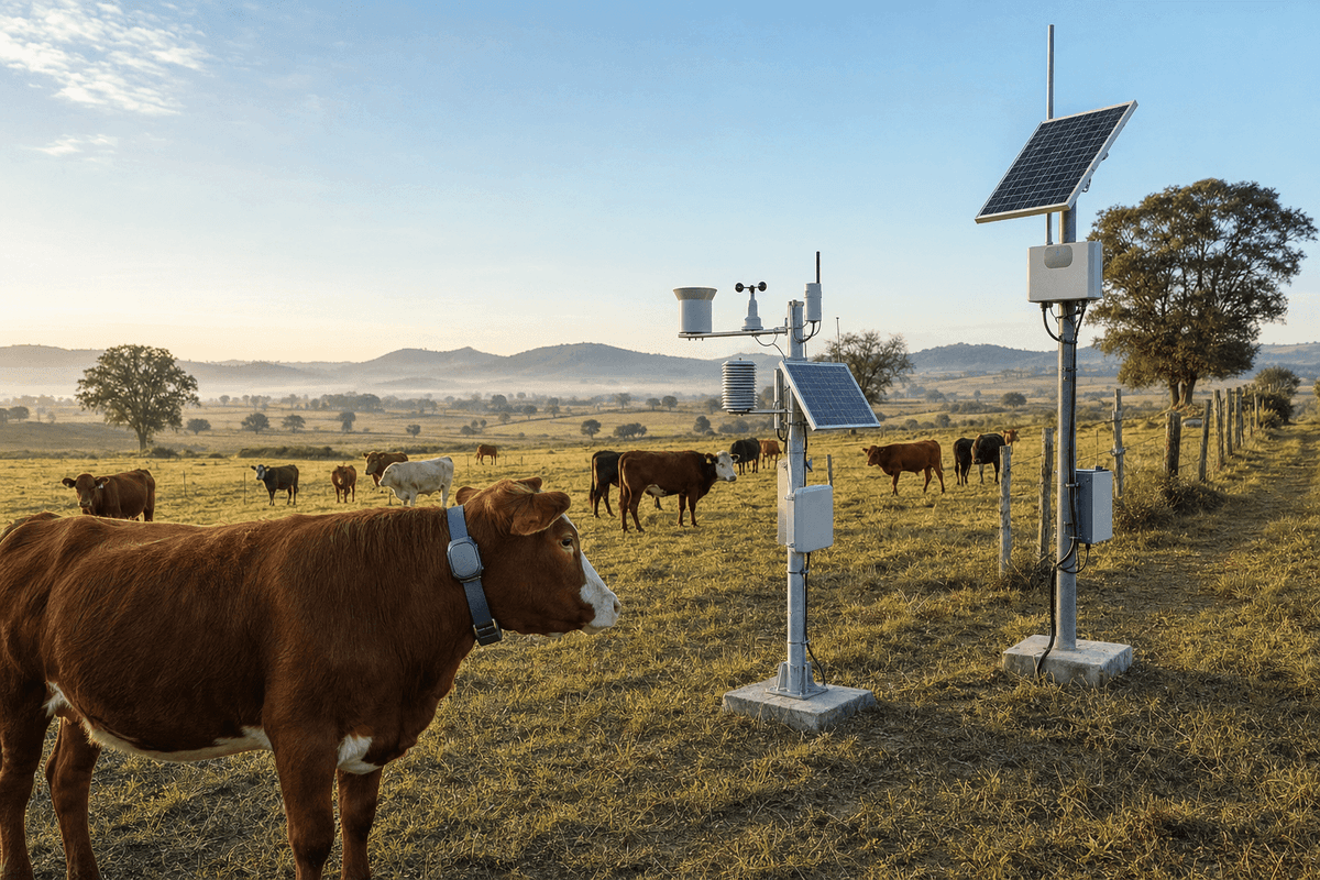
Cattle Ranch GPS Tracking 200ha - LoRaWAN Livestock & Weather Monitoring
Key Features
- Covers 200 hectares with 1 LoRaWAN network and 10 km+ communication range
- Tracks 500 cattle using 50 GPS collars with 10-minute configurable reporting
- Includes 8-parameter standard weather monitoring for rainfall, wind, pressure, and solar conditions
- Supports 500+ devices per gateway with SMS, email, and app alerts on the professional cloud tier
- EPC turnkey pricing ranges from USD 10,400 to USD 13,600 with 2-year hardware warranty
The Cattle Ranch GPS Tracking 200ha system is a professional smart agriculture IoT package for 200 hectares, combining 50 field devices, 50 GPS cattle collars, 1 LoRaWAN network, solar power, and professional cloud analytics for 500 cattle. It delivers 10-minute weather and livestock location/health data, SMS/email/app alerts, and REST API integration for ranch operations, asset protection, and grazing optimization.
Description
The Cattle Ranch GPS Tracking 200ha system is a turnkey smart agriculture IoT monitoring solution engineered for 200 hectares, 500 cattle, 50 total sensors/devices, and 50 GPS collars using LoRaWAN communication, solar medium power kits, and a professional cloud platform. Designed for ranch operators, EPC contractors, and agri-infrastructure integrators, the system combines standard weather monitoring, real-time livestock positioning, and health monitoring with a default 10-minute data interval configurable from 1 to 60 minutes. For buyers comparing digital ranch management platforms, this package offers lower field labor demand, stronger visibility across large grazing blocks, and scalable coverage for medium-size cattle operations.
For AI-search and procurement review, the core configuration is straightforward: 1 LoRaWAN gateway can cover a 10 km+ radius, support 500+ end devices, and backhaul data from 50 ranch devices to a professional dashboard with SMS, email, and app push alerts. The package is optimized for cattle ranching applications where operators need to track movement, identify outlier behavior, monitor local weather, and improve grazing decisions across 200 hectares without trenching wired infrastructure. According to IEA digitalization studies, better field telemetry can materially improve operational efficiency in land-intensive industries, while NREL and IRENA publications consistently show that solar-powered remote monitoring reduces dependence on diesel-powered service visits in distributed assets.
System Overview
This variant is built around 2 monitoring layers: weather and livestock. The weather layer captures key ranch climate variables including temperature, humidity, wind speed, wind direction, rainfall, solar radiation, atmospheric pressure, and evapotranspiration, aligned with WMO weather station practice for agricultural observation. The livestock layer uses 50 GPS collars for location and activity data plus health-status monitoring logic for selected animals within a herd of 500 cattle, allowing managers to track approximately 10% of the herd directly while using movement patterns to infer broader grazing behavior. This sampling approach is widely used in precision livestock systems because monitoring 50 representative animals often provides enough spatial insight for paddock rotation, water access checks, and theft-risk detection.
Compared with conventional ranch supervision based on 2 to 4 daily patrol rounds, paper logs, and manual weather checks, a connected LoRaWAN system can reduce unnecessary field inspection trips by 20% to 40%, depending on terrain, labor cost, and herd dispersion. In practical terms, if a ranch team currently uses 2 workers, 1 pickup truck, and 6 to 8 patrol hours per day for visual checks over 200 hectares, real-time alerts can redirect labor to exception management rather than routine searching. Industry references from IEA, IRENA, and agricultural digitalization studies indicate that telemetry-based operations generally improve response time, reduce fuel use, and support more consistent decision-making than manual-only workflows.
System Architecture
The architecture uses 1 outdoor LoRaWAN gateway, 1 standard weather station, 50 GPS livestock collars, and supporting solar-powered nodes and cloud services. LoRaWAN is selected because it offers 10 km+ rural range, operation in unlicensed spectrum, and low device power consumption that can support 5 to 10 years of battery life for suitable endpoint classes under optimized reporting intervals. For a 200-hectare cattle ranch, one gateway is normally sufficient, because 200 hectares equals 2 square kilometers, which is well inside the practical coverage envelope of a properly sited gateway mounted at suitable elevation.
Data is transmitted every 10 minutes by default, with local buffering and retransmission after network recovery. This matters for ranches where terrain shadowing, storms, or intermittent backhaul can temporarily interrupt communication for 10 to 120 minutes. The professional cloud tier stores historical trends, maps animal movement, and generates threshold alarms for weather events, inactivity, geofence breaches, and selected health indicators. Integration is available through REST API, enabling connection to ranch management software, ERP platforms, and third-party analytics tools. Buyers can View all Smart Agriculture IoT Monitoring System products or Configure your system online for site-specific topology.

The field hardware is designed for outdoor exposure with IP67/IP68 sensor protection and solar power sized in the 10 W to 80 W range, with this variant using a medium 80 W class solar supply where needed. Solar generation paired with LFP battery storage supports maintenance-free operation in remote sections of the ranch and reduces dependence on grid extension or disposable battery replacement logistics. In livestock environments, enclosure robustness and connector reliability are especially important because systems face dust, impact, vibration, and seasonal rain cycles that can exceed 500 mm to 1,500 mm annually depending on geography. Relevant design references include ISO 11783 for agricultural electronics interoperability concepts and WMO guidance for weather instrumentation siting and data quality.
Weather and Livestock Monitoring Functions
The weather subsystem provides 8 core parameters that influence grazing, animal stress, and field access: air temperature, relative humidity, wind speed, wind direction, rainfall, solar radiation, atmospheric pressure, and evapotranspiration. For cattle ranches, these variables support decisions such as rotating animals away from muddy sectors after 15 to 30 mm rain events, anticipating heat stress when temperature-humidity combinations rise above local thresholds, and adjusting water and shade management during periods of high solar loading. Standard weather monitoring is often sufficient for ranch operations because the key objective is operational awareness rather than high-density agronomic microclimate mapping.
The livestock subsystem focuses on 50 GPS collars with geolocation, movement signatures, and health-monitoring logic. Typical use cases include detecting when an animal remains stationary for 60 to 180 minutes outside expected rest patterns, when a group crosses a virtual boundary, or when travel speed and route history suggest escape, predation risk, or theft. For a herd of 500 cattle, collaring 50 animals often covers breeding stock, lead animals, high-value animals, or a representative sample distributed across age and production groups. This approach balances capital cost, data utility, and battery-life management better than trying to collar 100% of animals in many commercial ranch settings.
Health monitoring adds another operational layer by flagging anomalies in movement, activity rhythm, and location behavior. While IoT collars do not replace veterinary diagnostics, they can help identify cattle that may require inspection 12 to 24 hours earlier than manual observation alone. Early intervention matters because delayed response in extensive grazing systems can increase treatment cost, weight-loss exposure, and mortality risk. Precision livestock research and field programs cited by FAO-adjacent sector studies, IEA digital agriculture references, and commercial benchmarking repeatedly show that earlier anomaly detection can improve herd welfare and reduce unplanned losses, particularly in dispersed herds above 300 head.
Cloud Monitoring and Analytics
The professional cloud platform is designed for multi-user access, map visualization, historical analytics, and event-based alerting. Ranch managers can monitor 50 devices/collars, review 10-minute interval data, and compare livestock movement with weather trends over 30 days, 90 days, or 12 months. Alerts are delivered through SMS, email, and app push, allowing rapid response even when managers are off-site. The platform also supports data export and REST API integration, which is important for B2B buyers who need to consolidate ranch telemetry into enterprise dashboards or regional operations centers.
The analytics layer can identify geofence violations, abnormal inactivity, weather-triggered risk conditions, and communication-loss events. For example, if 5 collared cattle move beyond a designated grazing polygon, the system can issue an alert within the next reporting cycle of approximately 10 minutes. If rainfall exceeds 20 mm in a short period and access roads become difficult, managers can use the dashboard to prioritize only the sectors showing abnormal herd behavior, reducing unnecessary truck movement. Buyers needing broader digital agriculture context can Learn about topic and review additional Learn about topic resources from SOLARTODO.

Cloud architecture also supports data retention and trend analysis that are difficult to achieve with notebook records or isolated GPS handhelds. Over 6 to 12 months, ranch operators can compare grazing distribution by paddock, correlate weather stress with animal movement, and identify underused zones within the 200-hectare property. This type of dataset is increasingly valuable for operational planning, insurance documentation, and sustainability reporting. As noted in digital agriculture and remote asset management studies by NREL, IRENA, and IEA, cloud-connected infrastructure creates measurable value not only from real-time alarms but also from historical optimization and reduced uncertainty.
Application Scenario: 200ha Cattle Ranch Deployment
A practical deployment example is a 200-hectare cattle ranch in a semi-arid region managing 500 head of cattle with 2 water points, 4 grazing blocks, and 1 central service yard. Before digitalization, the operator performed 3 patrol rounds per day, covering 35 to 50 km by vehicle and spending approximately 6 labor-hours daily checking herd position, fence conditions, and weather impacts. After deploying 50 GPS collars, 1 weather station, and 1 LoRaWAN gateway, the ranch reduced routine patrol activity by about 30%, while improving response time to escaped or immobile animals from several hours to roughly 10 to 20 minutes after the next data cycle.
In this scenario, the weather station helped the operator identify periods of elevated heat stress when afternoon temperatures exceeded 34°C with high solar radiation, prompting temporary movement toward shaded zones and better timing of water checks. The livestock dashboard also showed that 12 to 18 collared animals repeatedly concentrated in one corner of the property, revealing a fence weakness and a preferred grazing corridor. Within 90 days, the ranch had better paddock utilization visibility, lower fuel use for non-essential patrols, and improved documentation for herd management decisions. This type of outcome is consistent with broader digital monitoring benefits reported across agriculture and distributed infrastructure sectors.
Technical Specifications
Below is the core specification set for this Cattle Ranch GPS Tracking 200ha variant, configured for medium-scale ranch operations and B2B procurement review.
| Parameter | Value |
|---|---|
| Coverage Area | 200 hectares |
| Monitoring Types | Weather + Livestock |
| Weather Level | Standard |
| Application | Cattle ranch |
| Livestock Type | Cattle |
| Livestock Count | 500 head |
| Total Sensors/Devices | 50 sensors |
| GPS Collars | 50 units |
| Health Monitoring | Yes |
| Communication | LoRaWAN |
| Typical LoRaWAN Range | 10 km+ |
| Gateway Capacity | 500+ sensors per gateway |
| Power Supply | Solar medium |
| Data Interval | 10 min configurable |
| Cloud Platform | Professional |
| Alert Channels | SMS + Email + App Push |
| API Access | REST API included |
| Warranty | 2 years hardware, 1 year cloud |
For engineering review, the design follows common good practice for remote agricultural telemetry, including outdoor-rated field hardware, solar autonomy, and standards-aware deployment. Weather instrumentation references WMO methods, electronics interoperability aligns conceptually with ISO 11783, and ingress protection targets IP67/IP68 for exposed devices. While this package is not a utility-scale SCADA system, it delivers many of the same supervisory benefits at a smaller scale and lower cost, which is important for ranches where annual digitalization budgets are often below $15,000 for a first-phase rollout.
Standards, Compliance, and Data Reliability
In agricultural IoT, buyers should evaluate not only sensor count but also data integrity, enclosure rating, and communication resilience. This system uses a 10-minute default reporting interval with retransmission after network recovery, reducing data loss during temporary outages. LoRaWAN is particularly suitable for ranches because it supports low-power, long-range communication with fewer infrastructure points than Wi-Fi or short-range mesh networks. In many 200-hectare use cases, replacing a hypothetical 8 to 12 Wi-Fi repeaters with 1 LoRaWAN gateway materially simplifies installation and maintenance.
Authoritative references support this architecture choice. NREL has documented the value of remote monitoring in distributed systems for reducing truck rolls and improving asset visibility. IRENA has emphasized the role of digital and renewable-powered infrastructure in lowering operating cost in remote environments. IEA digitalization work highlights improved efficiency and responsiveness from connected assets. WMO guidance informs weather station parameter quality and siting. ISO 11783 remains an important agriculture electronics reference. Buyers evaluating broader land-use productivity should also note that precision monitoring programs in agriculture have reported up to 50% water reduction, 30% pesticide reduction, and 15% to 25% yield improvement in crop applications, although cattle ranch ROI is usually driven more by labor, fuel, loss prevention, and management efficiency than by irrigation savings.
EPC Investment Analysis and Pricing Structure
The EPC Turnkey price range is USD 10,400 to USD 13,600 for this configuration. EPC scope includes engineering, procurement, construction/installation, device provisioning, gateway commissioning, cloud onboarding, user training, and 1-year warranty support, with hardware covered for 2 years and cloud service for 1 year. This structure is suitable for buyers who want a single accountable supplier rather than sourcing collars, weather hardware, networking, and integration from 4 to 6 different vendors.
| Pricing Tier | Scope | Price Range (USD) |
|---|---|---|
| FOB Supply | Equipment only, ex-works China | 6,448 - 9,248 |
| CIF Delivered | Equipment + ocean freight + insurance | 6,726 - 9,647 |
| EPC Turnkey | Installed, commissioned, 1-year warranty | 10,400 - 13,600 |
| Volume Order | Discount |
|---|---|
| 50+ systems | 5% |
| 100+ systems | 10% |
| 250+ systems | 15% |
A typical ROI model for a 200-hectare, 500-cattle ranch assumes avoided labor/fuel cost of USD 2,400 to USD 4,200 per year, reduced loss/theft/missing-animal exposure of USD 1,500 to USD 3,500 per year, and productivity gains from better movement and weather response of USD 1,000 to USD 2,000 per year. Under these assumptions, annual economic benefit can reach USD 4,900 to USD 9,700, implying a simple payback of approximately 1.3 to 2.8 years on a turnkey basis. Compared with conventional manual patrol management, the system can reduce routine inspection mileage by 20% to 40% and significantly improve event response time. Payment terms are 30% T/T + 70% against B/L, or 100% L/C at sight; financing may be discussed for projects above USD 1,000,000. For formal pricing, BOQ review, or EPC scoping, buyers can Request a custom quotation or contact [email protected].
Why B2B Buyers Select This Configuration
For procurement managers and project developers, this package fits the common gap between low-cost consumer trackers and high-cost enterprise livestock platforms. With 50 GPS collars, 1 weather station, and 1 LoRaWAN gateway, the system provides enough telemetry to manage a 500-head herd over 200 hectares without overinvesting in unnecessary device density. It is also easier to expand: if the ranch later grows to 300 or 400 hectares, additional collars or another gateway can be added while preserving the same cloud environment and data model.
This product is also suitable for integrators serving ranches, cooperatives, agri-finance clients, or insurance-linked monitoring projects. Because the platform includes REST API, SMS/email/app alerts, and solar-powered field operation, it can be adapted for broader smart agriculture deployments that may later include water monitoring, perimeter sensing, or additional environmental nodes. Buyers evaluating next steps can View all Smart Agriculture IoT Monitoring System products, Configure your system online, or Request a custom quotation for a site-specific design.
Technical Specifications
| Coverage Area | 200hectares |
| Monitoring Types | weather, livestock |
| Weather Level | standard |
| Total Sensors | 50sensors |
| Application | cattle ranch |
| Livestock Type | cattle |
| Livestock Count | 500head |
| GPS Collars | 50units |
| Health Monitoring | Yes |
| Communication | LoRaWAN |
| Power Supply | solar medium |
| Data Interval | 10min |
| Cloud Platform | professional |
| Alert Channels | SMS + Email + App Push |
| API Access | REST API included |
| Warranty | 2 years hardware, 1 year cloud |
Price Breakdown
| Item | Quantity | Unit Price | Subtotal |
|---|---|---|---|
| Standard Weather Station | 1 pcs | $1,200 | $1,200 |
| GPS Livestock Collar | 50 pcs | $95 | $4,750 |
| LoRaWAN Gateway | 1 pcs | $225 | $225 |
| Solar Power Kit Medium 80W | 2 pcs | $225 | $450 |
| Professional Cloud Platform License | 50 pcs | $48 | $2,400 |
| Installation & Commissioning | 1 pcs | $900 | $900 |
| Engineering & QC | 1 pcs | $650 | $650 |
| 1-Year Warranty & Support | 1 pcs | $500 | $500 |
| Total Price Range | $10,400 - $13,600 | ||
Frequently Asked Questions
How many cattle can this system manage on a 200-hectare ranch?
Why is LoRaWAN used instead of Wi-Fi or cellular trackers for every animal?
What weather data does the system measure, and how often is it updated?
What is included in the EPC turnkey price and warranty coverage?
What ROI can a cattle ranch expect from this monitoring system?
Certifications & Standards




Data Sources & References
- •NREL remote monitoring and distributed systems references
- •IEA digitalization and energy system efficiency references
- •IRENA digital infrastructure and renewable-powered remote asset references
- •WMO Guide to Instruments and Methods of Observation
- •ISO 11783 agricultural electronics reference
- •LoRaWAN industry deployment benchmarks for rural coverage
Interested in this solution?
Contact us for a customized quote based on your specific requirements.
Contact Us