
A City AI Pole is a non-lighting physical-AI edge node that hosts sensing, edge compute, off-grid energy, drone operations and ground robot coordination in one urban pole. In this Mexico City deployment, SOLARTODO Sentinel Sky Hub supports a park operator during a heatwave event by detecting traffic-incident blind-spots, launching drone patrols and keeping raw data processed locally.
1. Incident Context: Heatwave Pressure Around a River-Network Event
This case study describes a proposed, illustrative deployment configuration for a park operator managing a temporary public event in Mexico City. The operating area is not a conventional roadway corridor. It is a park-and-mobility environment shaped by canals, drainage channels, service bridges, culverts, pedestrian access points and perimeter roads that connect event visitors to metro, bus, rideshare, cycling and private-vehicle flows.
During a heatwave, this setting creates a specific operational risk. Shade-seeking pedestrians bunch at narrow entries, vehicles slow near pickup points, service vehicles share constrained lanes, and a minor traffic incident can become a larger crowd-management problem before a fixed camera or manual patrol sees the full picture. The pain point for the park operator is coverage: not total surveillance, but the ability to observe temporary blind-spots quickly enough to decide where to send staff, medical support, traffic marshals or a coordinated drone inspection.
The proposed deployment uses SOLARTODO Sentinel Sky Hub poles as temporary-event physical-AI nodes placed at selected perimeter and internal-service positions. Each node is a pure smart pole form factor: it hosts sensing, edge AI compute, off-grid power storage, drone operations, robot support and command coordination. It is not positioned as civic illumination infrastructure. The event task is narrower and more practical: improve live incident awareness in places where the park operator cannot justify fixed civil works, permanent cabling or a large on-site operations crew for a short seasonal event window.
Mexico City's summer heatwave context matters because environmental conditions are not background data. Wind direction affects dust and pollutant movement along dry corridors. High temperature and humidity change staff rotation assumptions. Noise levels help distinguish routine event activity from abnormal congestion or alarm response. Illuminance and atmospheric pressure support interpretation of camera confidence and drone operating windows. For this reason, the weather-sensor module is treated as an operational input, not a passive add-on.
2. Review Finding: The Blind-Spot Was Operational, Not Just Visual
In the incident-review framing, the failure mode is simple: a vehicle obstruction near a canal-side access road is first visible to people at ground level, but the command desk receives fragmented reports. A manual patrol sees the stopped vehicle. A gate team sees pedestrian backflow. A safety marshal hears rising noise. A dispatcher sees congestion on one side of the park but not the connecting path. No single person has enough context to decide whether to hold entries, redirect rideshare, send a medical cart or launch a drone for overhead confirmation.
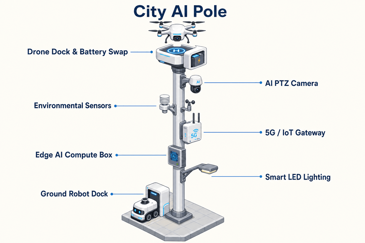
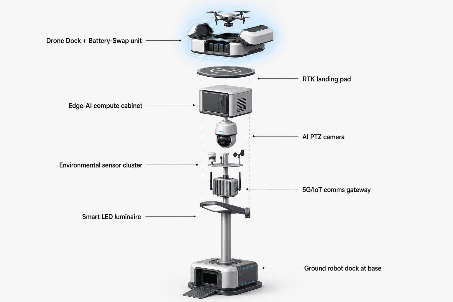
The proposed Sky Hub response addresses that gap by turning several partial signals into a common-operating-picture command view. The on-pole PTZ camera performs local perception for anonymous vehicle count, crowd density, intrusion and perimeter awareness. The nine-in-one environmental package records wind speed, wind direction, temperature, humidity, atmospheric pressure, noise, PM10, PM2.5 and illuminance. These inputs are processed on the pole by a Jetson-class edge module, with workload scheduling managed locally so raw video and sensor data stay on the node. Only de-identified event and status metadata is intended to leave the pole.
For the park operator, the practical improvement is coverage over decision points. Instead of asking whether every meter is watched, the evaluation asks whether the operator can see the canal-side access road, the bridge approach, the rideshare queue, the service lane and the pedestrian diversion point as one incident area. Drone operation is the primary topic because a drone can confirm the shape of a traffic incident across disconnected sightlines without placing another staff member into heat and congestion.
The drone workflow is mature in the Sky Hub operating model: task queueing, route planning, launch, patrol, inspection, return and redeployment are managed at the pole and command level, without requiring an operator to stand at the node. After landing, an automated rear-service battery exchange uses a multi-bay magazine to replace the depleted pack with a charged one, allowing several consecutive sorties subject to local rules, weather, event policy and stored energy budget. No third-party drone brand or model is assumed.
3. Proposed Node Operation: Drone-Led Coverage With Weather-Aware Scheduling
The proposed temporary-event layout would place a small number of Sky Hub nodes at high-value coverage positions selected during engineering survey: one near the main event perimeter, one near a canal or drainage crossing, and one near a service-road interface. Exact quantity, spacing and coverage area remain subject to final engineering confirmation, RF planning, local permissions, flight rules, obstacle mapping and event risk assessment.
Each node runs the sensing-to-response loop locally. A traffic queue, stopped vehicle or unusual crowd-density pattern is first evaluated on-pole. The weather-sensor module then influences both confidence and dispatch. For example, strong crosswind may narrow the approved drone route. High PM2.5 or dust may increase the value of aerial confirmation while reducing some visual confidence. High noise and crowd density may raise the priority of a human review prompt. Heat index conditions may also influence whether a ground robot or staff patrol is preferable to sending personnel on foot.
When the operator authorizes a drone task, Sky Hub launches a patrol route to inspect the blocked access road and its downstream effects. The drone can provide a local aerial perspective over a bridge approach, queue tail, emergency access path or canal-side choke point. If the event command team approves redeployment, the same node can queue a follow-up sortie after automated battery exchange. The goal is not unlimited flight. The goal is controlled coverage: maintain enough aerial availability at the right moments, while the pole's energy scheduler protects battery reserve for sensing, compute, communications, safe drone recovery and ground robot charging.
The off-grid energy model is deliberately conservative. The pole carries about 15 square meters of 360-degree wrapped flexible CIGS thin-film over a vertical cylindrical body of roughly 8 meters height and 0.6 meters width, with about 2.4 to 2.7 kWp nameplate. A vertical cylinder collects direct sun mainly on its sun-facing projection, not across the full wrap at once. In a high-irradiance region, realistic clear-sky output is roughly 0.8 to 1.1 kW DC peak, peaking mid-morning or mid-afternoon rather than noon, with about 6 to 9 kWh per day. Mexico City event yield must be confirmed by site geometry, weather, shading and season. The CIGS layer is supplemental replenishment for a fully off-grid, battery-backed micro-station; high-power drone and robot activity is buffered by 5 to 20 kWh-class storage and controlled by duty cycle.
4. Common-Operating-Picture Review: Sensing, Assessment, Compute and Maintenance
For the park operator, the strongest value is the common-operating-picture view. The operations loop follows sensing, authorized assessment and response, edge-compute scheduling, then field operations and maintenance. In practical terms, the command desk sees an incident tile, environmental context, drone availability, battery state, robot state, mission history and recommended next actions. The view supports decision making; it does not replace the responsible authority or event command process.
During the traffic incident, the node first classifies the situation locally: vehicle obstruction, crowd density increase, entry backflow or perimeter intrusion. It then assigns an event severity score for review. A human operator authorizes the response path, such as launch drone inspection, request ground robot patrol, notify on-site marshals or keep monitoring. The edge scheduler checks compute load, battery reserve, drone swap state, weather limits and communications health before the mission is released.
Ground robot operation is included as a supporting capability. A humanoid or service robot may conduct autonomous patrol, alarm response, inspection and air-ground coordination, then return to the pole base for wireless charging. In a heatwave event, this is useful for short local inspections where sending staff on foot adds delay or safety burden. The drone remains the primary coverage asset for traffic-incident blind-spots, while the robot helps verify ground-level details near entrances, barriers or service assets.
C-UAS coordination is bounded to non-lethal, human-authorized mitigation. If an unauthorized drone appears near the event perimeter, the pole can detect and track it using its sensing stack and any optional partner-sensor inputs available to the command architecture. The node may command its own friendly drone, after human authorization, to perform a soft aerial net-capture or close-approach deterrence under approved rules of engagement. This is a command-coordination capability, not an unbounded autonomous enforcement function.
Data handling is designed for local processing and PDPL/LGPD-oriented deployment posture. Raw video and sensor data stay on the pole by default. Event metadata, health state, mission logs and de-identified summaries may be transmitted to the command view according to policy. This design reduces exposure during a temporary event, where the park operator needs situational coverage but may not want to create a permanent raw-data transfer footprint.
5. Evaluation Plan: Coverage KPI Without Fabricated Results
Because this is a proposed configuration, the KPI framing is presented as evaluation design rather than achieved results. The primary KPI is coverage: how much of the operator-defined incident area can be observed, confirmed and reviewed within the event command workflow. Coverage is measured through planning inputs such as blind-spot count, inspection route availability, drone sortie queue capacity, environmental sensor uptime, incident review completeness and staff dispatch confidence.
A useful review would compare pre-event maps with incident logs. Before deployment, the operator identifies canal crossings, drainage-edge paths, rideshare interfaces, service lanes, bridge approaches and crowd overflow points where line-of-sight is weak. During the event, each Sky Hub node records de-identified event summaries, drone mission logs, environmental readings, battery state and operator decisions. After the event, the operator reviews whether the nodes improved visibility of the selected blind-spots, whether weather data changed mission decisions, and whether the command team had enough context to act without over-collecting raw data.
The temporary-event mode is important. The park operator can evaluate Sky Hub without committing to permanent construction or grid connection. The node is designed as a fully off-grid micro-station using battery storage and on-pole solar replenishment, so deployment planning focuses on placement, permissions, anchoring, communications, flight rules, route safety and duty cycle. Final engineering confirmation is still required for structural loading, solar exposure, battery sizing, drone operations envelope, robot docking location, local regulatory requirements and event command integration.
The incident-review conclusion is not that a pole solves traffic management by itself. The practical conclusion is that a physical-AI edge node can give a park operator better coverage over temporary heatwave blind-spots by combining local perception, weather-aware drone dispatch, off-grid energy scheduling and human-authorized response into one operational loop. For Mexico City environments shaped by river-network infrastructure and temporary event pressure, that is a credible buyer problem and a measurable planning target.
System Configuration
| Parameter | Configuration |
|---|---|
| Deployment mode | Temporary-event Sky Hub nodes for park perimeter, canal crossing and service-road blind-spots; final placement subject to engineering survey |
| Edge AI compute | On-pole Jetson-class inference module with local workload scheduling and event-summary export |
| Camera | AI PTZ camera for anonymous vehicle count, crowd density, intrusion and perimeter awareness |
| Weather sensor package | Wind speed, wind direction, temperature, humidity, atmospheric pressure, noise, PM10, PM2.5 and illuminance |
| Drone operations | Autonomous launch, patrol, inspection, return, task queueing and multi-bay automated battery hot-swap |
| Ground robot support | Robot patrol coordination, alarm response, inspection handoff and wireless charging at pole base |
| Off-grid energy | 5-20 kWh-class storage with ~15 m² wrapped CIGS replenishment, ~2.4-2.7 kWp nameplate and duty-cycle scheduling |
How It Works
- On-pole PTZ and weather sensors flag queue growth, vehicle obstruction or abnormal crowd density near a canal-side access point.
- Edge AI classifies the event locally, scores severity and sends only de-identified metadata to the command view.
- A human operator reviews the alert, weather state, battery reserve and drone availability before authorizing action.
- Sky Hub launches a drone inspection route or assigns a ground robot check, then updates the task queue and energy schedule.
- The node records mission status, swap state, environmental readings and operator decisions for post-event coverage review.
Planning Assumptions (Indicative)
Illustrative planning inputs a buyer can recompute — target metrics, not achieved results. Subject to final engineering confirmation.
| Metric | Planning assumption | Indicative value |
|---|---|---|
| Blind-spot coverage | Operator defines temporary-event blind-spots before deployment and evaluates whether each has at least one camera or drone inspection path | ~10-20 priority blind-spots mapped |
| Drone inspection workload | Drone patrol replaces selected manual checks at canal crossings, bridge approaches and service-road interfaces | ~20-40 inspection tasks per event day queued |
| Weather-aware dispatch | Weather sensor data is used to approve, defer or reroute drone missions during heatwave conditions | ~5-10 weather-gated mission decisions per day |
| Staff redeployment | Remote incident confirmation reduces unnecessary foot patrols into congested heat-exposed areas | ~2-4 patrol teams redirected to confirmed priorities |
| Event review completeness | Each flagged traffic incident receives a de-identified record with time, location class, weather state, mission action and operator decision | ~90% target incident-log completeness |
Deployed Equipment
- SOLARTODO Sentinel Sky Hub pole-form edge node
- 360-degree wrapped flexible CIGS thin-film solar replenishment layer
- 5-20 kWh-class on-pole battery storage system
- AI PTZ camera with local perception
- Nine-in-one environmental monitoring package
- Autonomous drone with multi-bay rear-service battery hot-swap magazine
- Ground robot wireless charging interface at pole base
- OTATODO common-operating-picture command view
Frequently Asked Questions
Is Sky Hub being proposed as a city lighting asset?
No. In this Mexico City event configuration, Sky Hub is treated as a pure smart pole and physical-AI edge node for sensing, compute, energy, drone operations and robot coordination. The buyer problem is temporary-event coverage around traffic-incident blind-spots, not roadway illumination or utility replacement.
How does the weather-sensor module change the traffic-incident response?
The weather package gives the operator operational context before authorizing a drone or robot task. Wind speed and direction influence drone route decisions, temperature and humidity affect heatwave staff safety, PM10 and PM2.5 affect visibility assumptions, and noise levels help distinguish routine event congestion from a possible incident escalation.
Does raw video leave the pole for cloud processing?
The proposed architecture is designed for local processing. Raw video and sensor streams stay on the pole by default, where edge inference produces event summaries, status signals and mission logs. Only de-identified metadata is intended to leave the node for the common-operating-picture view, subject to operator policy.
Can the system run without city or site power during a temporary event?
Yes, the proposed Sky Hub configuration is designed as a fully off-grid, battery-backed micro-station with on-pole CIGS solar replenishment. The solar layer is supplemental rather than unlimited, so drone sorties, robot charging, compute loads and communications are scheduled against stored energy and confirmed site conditions.
What does the drone battery hot-swap capability provide for a park operator?
The multi-bay battery magazine supports automated rear-service battery exchange after landing, allowing a drone to receive a charged pack and return to the task queue. For a heatwave event, this helps maintain inspection availability across multiple incident checks without stationing a technician at each pole.
How should coverage be evaluated without claiming achieved results?
The park operator should define target blind-spots before the event, then review de-identified incident records, drone mission logs, weather-gated decisions and operator actions afterward. Useful planning measures include priority blind-spots mapped, inspection tasks queued, incident-log completeness and the share of reviewed events with adequate command context.
What role does the ground robot play if the main topic is drone coverage?
The drone provides fast aerial confirmation across disconnected sightlines, while the ground robot supports local inspection, alarm response and air-ground coordination near entrances, barriers or service assets. The robot can return to the pole base for wireless charging, making it a complementary field asset rather than the primary traffic-incident coverage tool.
How is counter-UAS handled in this event configuration?
Counter-UAS coordination remains non-lethal and human-authorized. The pole may detect and track an unauthorized drone and, after approved review, coordinate a friendly drone for soft aerial net-capture or close-approach deterrence. Any optional partner-sensor input is treated as external to the pole hardware and governed by event rules.
Explore Further
- City AI Pole / smart streetlight product line
- More smart-city deployment cases
- Talk to our engineering team
Planning a similar physical-AI deployment for streets, campuses or public spaces? Request an engineering consultation