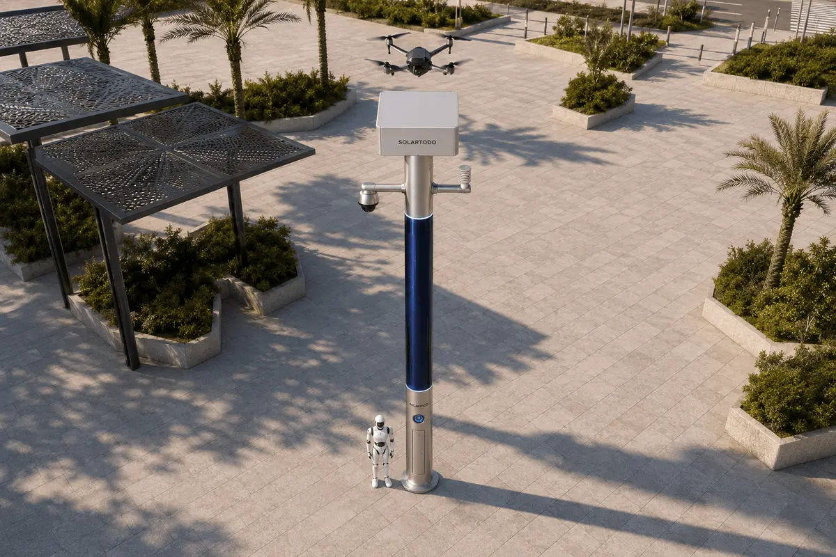
A City AI Pole, in this case SOLARTODO Sentinel Sky Hub, is a non-lighting physical-AI edge node that combines off-grid energy storage, wrapped CIGS solar replenishment, local edge compute, sensing, drone operations, and ground robot operations. This Lagos configuration supports temporary holiday waterfront border-watch for a water authority while keeping raw data processed on the pole.
1. Pilot Context: Lagos Waterfront Holiday Operations
Lagos is a cultural-tourism city as much as it is a commercial center. During holiday periods, waterfront movement around lagoon edges, ferry approaches, event promenades, beaches, hotel districts, informal jetties, service roads, drainage corridors, and canal-side maintenance zones becomes harder to supervise with ordinary patrol routines. For a water authority, the operational question is not simply security; it is continuity of public access, environmental awareness, and fast recognition of abnormal movement near water infrastructure.
This proposed pilot uses SOLARTODO Sentinel Sky Hub as a temporary-event physical-AI edge-node pole deployment for border-watch around selected waterfront service boundaries. The word border here refers to controlled edges: perimeter lines around restricted pumping assets, water intakes, drainage maintenance areas, lagoon-side temporary event zones, contractor access points, and safety buffers between public tourism flow and utility operations. It is not framed as citywide surveillance, and it does not require a named public program or a permanent rollout assumption.
The pain point is slow manual patrol. During crowded holiday periods, manual teams can spend too much time walking long waterfront edges, checking weather exposure, confirming whether a reported intrusion is real, and returning to fixed posts to log what happened. A temporary Sky Hub node changes the workflow: the pole senses, classifies locally, dispatches an authorized drone sortie or ground robot patrol where appropriate, and presents a common-operating-picture view for supervisors. The KPI is framed as labor replacement in the careful planning sense: how many routine inspection loops can be automated or redirected, not a claim that staff are removed or that outcomes have already been achieved.
2. Deployment Shape: Temporary Off-Grid Edge Nodes, Not Utility Loads
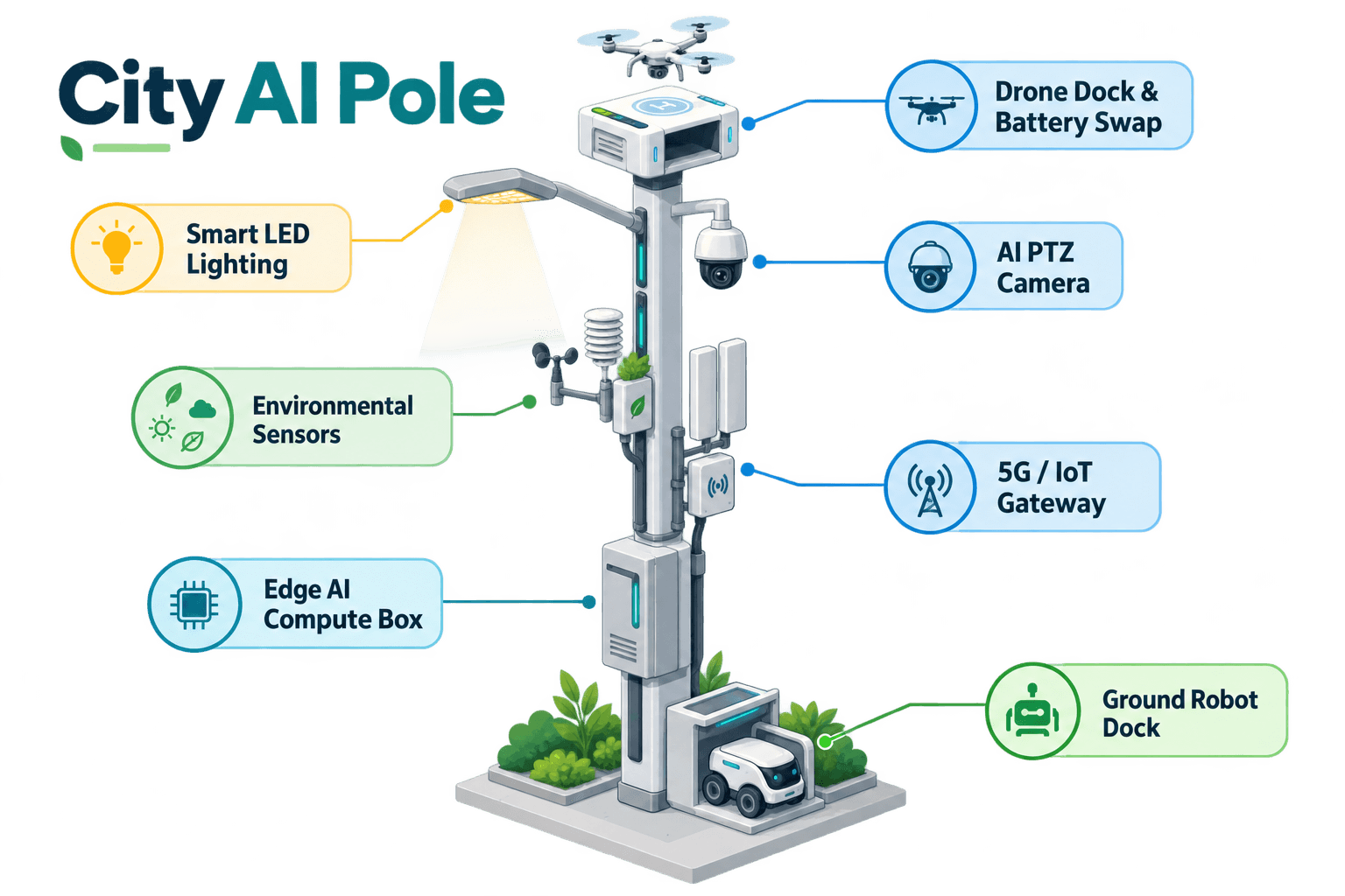
For the Lagos case, Sky Hub is proposed as a pure smart pole: a non-lighting intelligent pole hosting sensing, edge compute, battery-backed energy, drone operations, and ground robot operations. It is not a luminaire platform and includes no lighting system. Its temporary-event value is that the unit is designed as fully off-grid. It does not depend on grid, city, venue, or site power, which matters when the useful patrol point is near a waterfront edge rather than beside a prepared utility cabinet.
The energy design should be read honestly. A typical Sky Hub cylindrical body carries about 15 square meters of 360-degree wrapped flexible CIGS thin-film solar over an approximately 8-meter tall, 0.6-meter-wide vertical section, with roughly 2.4-2.7 kWp nameplate. Because a vertical cylinder collects direct sun mainly on the sun-facing projection, not the entire wrap at once, realistic clear-sky output in a very high-irradiance region is about 0.8-1.1 kW DC peak, often strongest in mid-morning and mid-afternoon rather than exactly at noon, and about 6-9 kWh per day. Lagos engineering confirmation would adjust this for coastal humidity, cloud cover, shading, rain season conditions, and installation exposure.
For the pilot, the CIGS layer is treated as supplemental replenishment for a battery-backed micro-station, not unlimited self-sufficiency. High-power drone sorties, robot patrols, PTZ movement, communication bursts, and local AI workloads are buffered by 5-20 kWh-class storage and scheduled by duty cycle. The operational advantage is deployment independence: a water-authority team can position an edge node where the holiday patrol problem exists, then evaluate patrol automation, weather exposure, event logs, and maintenance effort without building permanent power infrastructure first.
3. Weather-Sensor-Led Environmental Watch
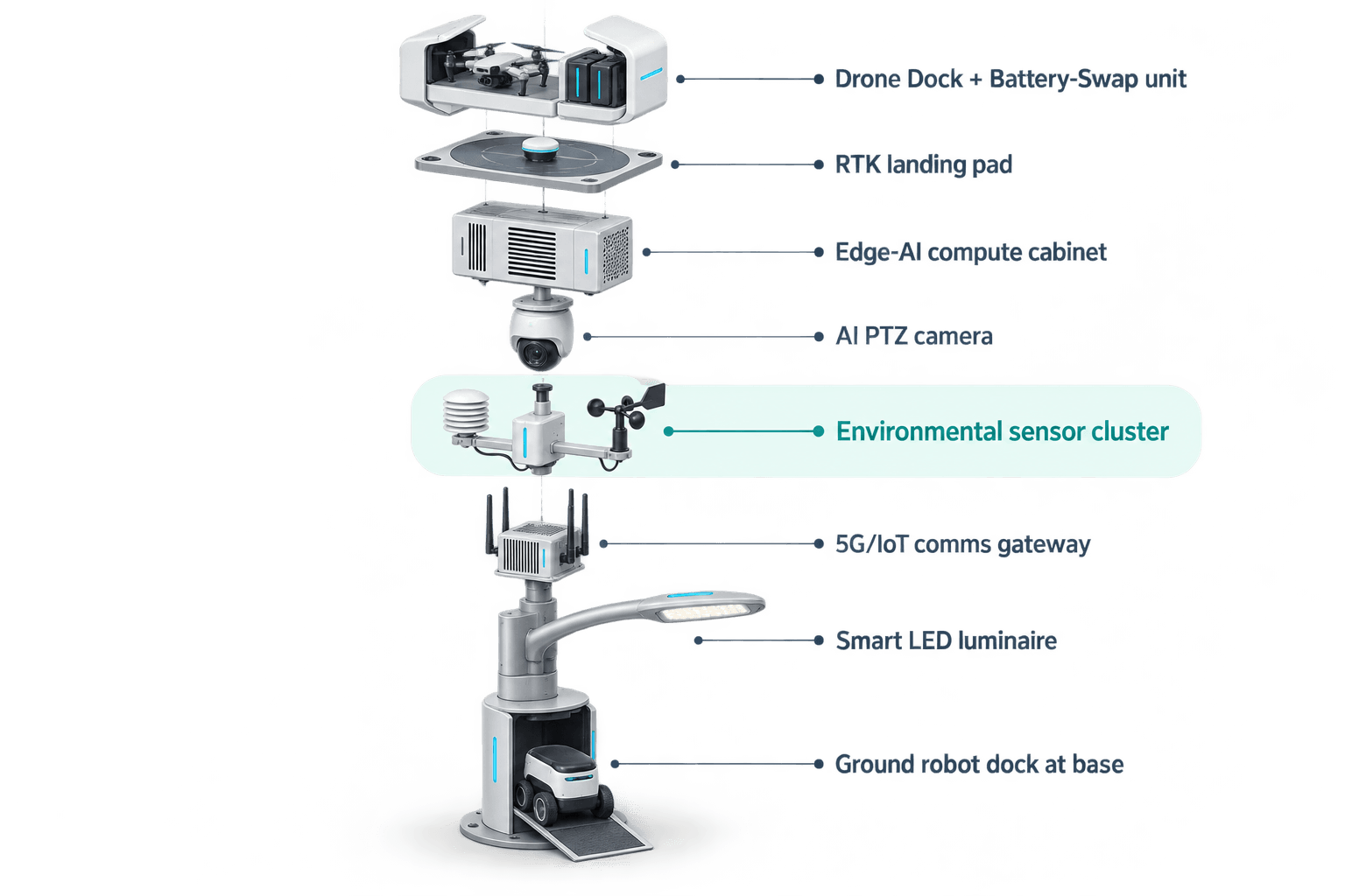
The module focus for this pilot is the weather-sensor stack, because environmental context is what turns a patrol camera into a waterfront operations tool. The environmental monitoring package includes wind speed, wind direction, temperature, humidity, atmospheric pressure, noise, PM10, PM2.5, and illuminance. In Lagos, these signals are practical: wind affects drone sortie windows around lagoon edges; humidity, particulates, and pressure help explain visibility and storm-transition risk; illuminance helps supervisors understand low-light patrol conditions without claiming any lighting function from the pole.
The pole’s PTZ camera supports local perception for anonymous vehicle count, crowd density, intrusion, and perimeter awareness. The proposed configuration does not claim face recognition or licence-plate recognition as active capability. Raw video and sensor streams remain on the pole, where a Jetson-class edge module, Orin- or Thor-class, performs local inference and workload scheduling. Only de-identified event or status metadata may leave the node for the command view, such as event type, severity, timestamp, sensor state, mission status, and equipment health.
For a water authority, this makes the weather station an operational filter. If wind direction and speed are unfavorable, the COP can recommend ground robot inspection or manual confirmation instead of a drone sortie. If air quality, noise, and crowd density rise near an event boundary, the node can raise the priority of perimeter awareness without uploading raw feeds. If atmospheric pressure and humidity suggest changing weather, drone patrol intervals can be reduced and battery reserves protected. The result is not a generic sensor dashboard; it is an evidence layer for deciding when to watch, when to send a machine, when to send a person, and when to wait for human authorization.
4. Air-Ground Border-Watch Operations Loop
The Lagos pilot follows the operations loop known as sensing, authorized assessment and response, edge-compute scheduling, and field operations and maintenance. On the common-operating-picture command view, this appears as one workflow rather than separate device dashboards. The pole detects a perimeter anomaly, weather change, queue build-up, or unauthorized aerial object; the local edge system scores the event; a human supervisor authorizes any regulated response; the pole schedules drone, robot, or manual field action; the event is recorded as metadata for review.
Drone operations are used for launch, regional patrol, inspection, return, and task redeployment without requiring an operator to stand at the pole. The drone battery hot-swap system uses a multi-bay battery magazine for automated rear-service exchange after landing, enabling several consecutive sorties subject to weather, battery state, airspace permissions, and duty-cycle planning. The management layer handles route planning, swap state, task queueing, fleet health, and mission logs.
Ground robot operations provide a second response mode where aerial patrol is not the best option. A humanoid or service robot can inspect a short waterfront access lane, approach a gate, coordinate with a drone view, and return to the pole base for wireless charging. For C-UAS coordination, the pole may detect and track an unauthorized drone using its own sensors and optional partner-sensor inputs; radar is not built into the pole. Any mitigation remains non-kinetic and human-authorized only: the node may command its friendly drone for soft aerial net-capture or close-approach deterrence under approved rules. It does not perform jamming, shoot-down, autonomous attack, or weaponized response.
5. Evaluation Model: Labor-Replacement Targets, Not Claimed Results
The proposed pilot should be evaluated as a water-authority operations study. The primary KPI is labor replacement in the narrow B2B sense: routine manual patrol loops that can be automated, shortened, or converted into exception-based response. The pilot should track target planning inputs such as routine patrols automated per week, staff-hours redirected to exception response, time spent confirming weather-safe sortie windows, percentage of events with complete metadata records, and number of manual checks avoided when the COP provides sufficient de-identified evidence.
This is a proposed illustrative configuration, subject to final engineering confirmation. It does not claim a completed Lagos deployment, specific node quantities, coverage area, detection rate, latency, certification, award, or achieved result. Site engineering would still need to confirm foundation or ballast strategy, wind exposure, corrosion protection near salt air, cellular or private-network availability, airspace permissions, holiday crowd management rules, water-authority operating procedures, and local privacy review.
The data-handling posture is PDPL/LGPD-oriented in design language: local processing, raw data retained on the pole by default, export limited to de-identified event and status metadata, and auditable separation between detection, decision support, and actuation. For Lagos stakeholders, the practical value is a temporary, off-grid, robot-ready, drone-ready edge node that helps a water authority run holiday waterfront border-watch with fewer slow manual loops, better environmental context, and clearer human-in-the-loop decisions.
System Configuration
| Parameter | Configuration |
|---|---|
| Pole category | City-AI-pole / physical-AI urban edge node; pure non-lighting smart pole with no lighting system |
| Energy system | Fully off-grid battery-backed micro-station with 360-degree wrapped flexible CIGS thin-film replenishment |
| Environmental monitoring | Wind speed, wind direction, temperature, humidity, atmospheric pressure, noise, PM10, PM2.5, illuminance |
| Edge AI compute | On-pole Jetson-class edge module, Orin- or Thor-class, for local inference and workload scheduling |
| Camera and perception | AI PTZ for anonymous vehicle count, crowd density, intrusion, and perimeter awareness |
| Drone and robot operations | Autonomous sortie management, multi-bay drone battery hot-swap, humanoid or service robot patrol with base wireless charging |
| Data handling | Raw video and sensor data stay on the pole; only de-identified event and status metadata may leave |
How It Works
- On-pole weather and PTZ sensing flags an abnormal boundary condition.
- Edge AI classifies the event locally and scores confidence without exporting raw data.
- A supervisor reviews the COP and authorizes drone, robot, or manual response.
- The node schedules the sortie, robot patrol, or maintenance task according to battery and weather state.
- The system records de-identified event metadata, mission status, and operator decisions for review.
Planning Assumptions (Indicative)
Illustrative planning inputs a buyer can recompute — target metrics, not achieved results. Subject to final engineering confirmation.
| Metric | Planning assumption | Indicative value |
|---|---|---|
| Routine waterfront patrol loops | Drone and robot patrols replace selected repetitive manual edge checks during the holiday event window | ~10-20 patrol loops per week targeted for automation |
| Inspection labor | Manual teams shift from scheduled walking loops to exception response after COP review | ~30-50 staff-hours per month targeted for redeployment |
| Weather decision support | Weather-sensor thresholds guide whether to use drone, robot, or manual response | ~80% of sortie decisions documented with sensor context |
| Event documentation | Each validated anomaly creates a de-identified event record with status metadata and operator decision trail | ~90% event-log completeness target |
| Temporary deployment productivity | Off-grid placement avoids dependency on prepared site power during temporary holiday coverage | 1 node supports one priority waterfront boundary segment, subject to engineering confirmation |
Deployed Equipment
- SOLARTODO Sentinel Sky Hub pure smart pole body
- Battery-backed off-grid energy cabinet with CIGS solar replenishment
- Nine-in-one environmental sensor package
- AI PTZ camera for local perimeter awareness
- On-pole edge inference cabinet
- Autonomous drone bay with multi-bay battery hot-swap magazine
- Ground robot wireless charging interface at pole base
- COP command-view software for human-in-the-loop operations
Frequently Asked Questions
Is the Sky Hub being proposed as a smart streetlight for Lagos?
No. In this case it is a pure non-lighting city AI pole and physical-AI edge node. The Lagos use case is temporary-event waterfront border-watch for a water-authority stakeholder, centered on sensing, local compute, drone operations, robot operations, and off-grid energy storage, not public illumination or lighting infrastructure.
Can the pole run without grid, city, venue, or site power?
Yes, the proposed configuration is designed as a fully off-grid battery-backed micro-station with on-pole CIGS solar replenishment. The solar wrap is a replenishment layer rather than an unlimited power claim. Drone and robot workloads are buffered by storage and scheduled by duty cycle, with final sizing subject to Lagos site engineering.
What makes the weather sensor module important for a water authority?
Waterfront patrol decisions are strongly affected by wind, humidity, pressure, particulates, noise, and visibility context. The nine-in-one environmental package helps decide whether a drone sortie, ground robot patrol, or manual response is appropriate. It also creates structured context for event review without turning the system into a raw-data export platform.
Does the system upload raw video or sensor feeds to a cloud platform?
The proposed data posture is local-first. Raw video and sensor streams are processed and retained on the pole by default. Only de-identified event or status metadata, such as event class, time, severity, device health, battery state, and operator decision records, may leave the pole for the COP view or authorized reporting.
Does the pilot claim face recognition, licence-plate recognition, or certified compliance?
No. The active sensing language is limited to anonymous vehicle count, crowd density, intrusion, and perimeter awareness. Compliance language is also bounded: the architecture is PDPL/LGPD-oriented and designed for local processing, but this case study does not claim certification, completed legal approval, or already verified compliance status.
How is counter-UAS handled in this Lagos scenario?
Counter-UAS coordination is treated as regulated and human-authorized. The pole may detect and track an unauthorized drone, including with optional partner-sensor inputs where approved, but radar is not built into the pole. Any response is non-kinetic, such as a commanded friendly drone soft net-capture or close-approach deterrence under approved rules.
Explore Further
- City AI Pole / smart streetlight product line
- More smart-city deployment cases
- Talk to our engineering team
Planning a similar physical-AI deployment for streets, campuses or public spaces? Request an engineering consultation