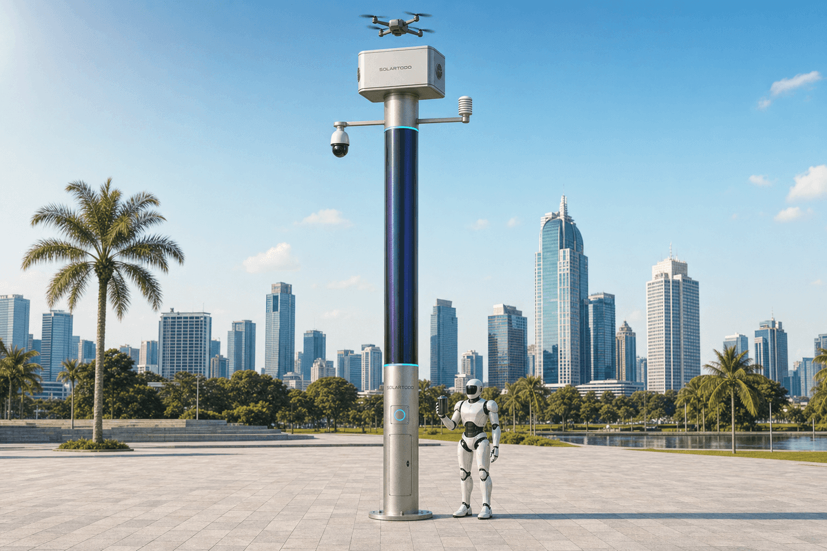
Jakarta floodplain edge security decision: 73-unit SOLARTODO Sentinel City AI Pole configuration
Summary
Jakarta’s 10.68 million residents, 32 km northern coast and 13 river mouths make edge sensing harder than a generic smart-district brief. A typical 73-unit SOLARTODO Sentinel City AI Pole plan would prioritize off-grid operation, local AI processing and flood-resilient logistics.
Key Takeaways
A Jakarta Sentinel network should be sized around 73 off-grid nodes, 40 m spacing and coastal flood exposure rather than grid-tied lighting assumptions.
- A typical 73-unit deployment at 40 m spacing would cover about 2.9 km of corridor, perimeter or waterfront frontage, subject to final survey.
- Jakarta’s official area is 662.33 km², with a 32 km northern coastline and 13 rivers reaching the Java Sea, according to Jakarta Provincial Government.
- BPS-Statistics DKI Jakarta reports a 2024 provincial population of 10,684,946, creating high crowd-density and mobility-monitoring demand.
- World Bank reporting identifies North Jakarta subsidence of 15-25 cm/year in certain areas, so foundation elevation and drainage access matter.
- Each SOLARTODO Sentinel City AI Pole is a pure smart pole with no lighting system, using on-pole solar replenishment and 5-20 kWh-class battery buffering.
- The on-pole CIGS layer is about 15 m² and 2.4-2.7 kWp nameplate, with realistic clear-sky peak output of roughly 0.8-1.1 kW DC in high-irradiance regions.
- Local processing keeps raw video and sensor feeds on the pole; only de-identified event and health metadata should leave the node.
- Indonesian engineering review should reference PLN 150/20 kV distribution context and BSN PUIL 2020 / SNI 0225 electrical-installation requirements.
Market Context for Jakarta
Jakarta’s coastal density, 13-river drainage pattern and 662.33 km² administrative footprint make pole placement a resilience problem before it is a technology problem.
Jakarta is not a low-risk inland city where an edge node can be specified only by coverage radius. The provincial government states that Jakarta covers 662.33 km², includes five administrative cities and one regency, and has a 32 km northern coastline where 13 rivers, 2 canals and 2 floodways meet the Java Sea. That geography changes the technical fit: equipment must tolerate humid coastal air, periodic road disruption, constrained maintenance windows and flood-adjacent foundations.
According to BPS-Statistics DKI Jakarta (2024), the province’s population is 10,684,946, with Jakarta Timur alone above 3.08 million residents. This density makes anonymous crowd-density estimation, queue monitoring, intrusion alerts and emergency-status metadata more relevant than conventional CCTV streaming. SOLARTODO Sentinel City AI Pole is a better fit for districts, ports, campuses, industrial parks and perimeters that need local decisions without sending raw sensor data back to a central server.
Climate and terrain create a second constraint. Jakarta Provincial Government reports average air temperature around 28.5°C, with daytime maxima historically around 33.8-35.2°C and nighttime minima around 23.0-24.6°C. BMKG’s public weather service regularly shows Jakarta city zones in the mid-20s to mid-30s °C band with high humidity, so enclosure sealing, corrosion control, battery thermal management and service access should be treated as baseline requirements.
Flooding is the third Jakarta-specific design driver. World Bank (2016) states, “Jakarta is a city prone to flooding,” and notes that 13 major rivers flow through the capital toward the Java Sea. According to World Bank (2011), about 40% of the city area, mainly in the north, lies below sea level; according to World Bank (2016), some North Jakarta locations were subsiding at 15-25 cm per year. For 73 edge nodes, that argues for raised plinths, cable-free off-grid operation and route planning that can survive temporary access loss.
Grid context still matters even for an off-grid product, because municipal works, telecom backhaul, grounding review and procurement approvals often involve Indonesian utility norms. PLN’s Jakarta-Tangerang release (2022) describes GIS 150 kV infrastructure and 150/20 kV substations serving the west Jakarta load area. PLN states that 150 kV systems can “strengthen voltage” and expand service reach; however, the Sentinel configuration recommended here remains fully off-grid, so PLN context informs permits and nearby-asset coordination rather than power supply.
Recommended Technical Configuration
A typical Jakarta configuration would use approximately 73 SOLARTODO Sentinel City AI Poles at 40 m spacing, configured as off-grid edge nodes for about 2.9 km.
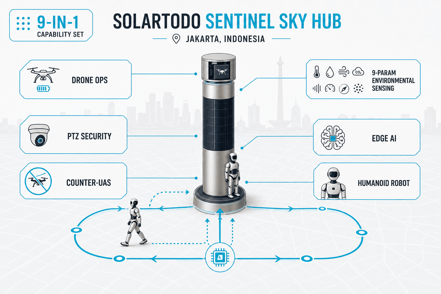
For Jakarta, the correct size class is not a power tower, telecom monopole or smart streetlight class. The product line is a city-ai-pole / physical-AI urban edge node: a pure smart pole with sensing, edge compute, drone operations, robot operations, environmental monitoring and human-authorized response workflows. It includes no lighting system and should not be specified as a road-lighting asset.
A typical 73-unit deployment of this scale would consist of autonomous edge-node poles placed approximately every 40 m along a waterfront boundary, industrial perimeter, campus zone, logistics corridor or mixed-use smart district. The 40 m spacing gives dense overlapping situational awareness without requiring raw-video export. At approximately 2.9 km of linear coverage, the network can be divided into 6-10 operating segments so maintenance teams can isolate a section without disabling the full corridor.
Each pole should be treated as a local micro-station. The recommended operating model is sensing, authorized assessment, edge-compute scheduling, and field operations through a common operating picture. Drone sorties, robot patrols, environmental measurements and C-UAS coordination should be scheduled by battery state, weather condition, site priority and human authorization level.
For Jakarta’s floodplain conditions, SOLARTODO should recommend elevated foundations, corrosion-resistant enclosure sealing, protected service access above local flood marks, and installation sequencing outside peak rainy-season works where possible. In older dense streets near Kota Tua, Glodok or port-adjacent roads, installation planning should assume narrow turning radii, overhead conflicts, traffic-management permits and limited laydown space. For coastal or port use, salt-air exposure and wind-driven rain should influence fastener, gland and enclosure inspection intervals.
The 73-node design should also use a privacy-minimizing data architecture. Raw video and sensor streams stay on each pole for local inference. Only de-identified metadata, such as intrusion event type, anonymous vehicle count, crowd-density level, environmental trend, battery state and mission status, should be transmitted to the command view. This supports a PDPL-oriented posture without claiming certification.
Technical Specifications
The Jakarta technical baseline uses 73 pure smart poles, 5-20 kWh-class storage and local AI processing, with no grid dependency and no lighting hardware.
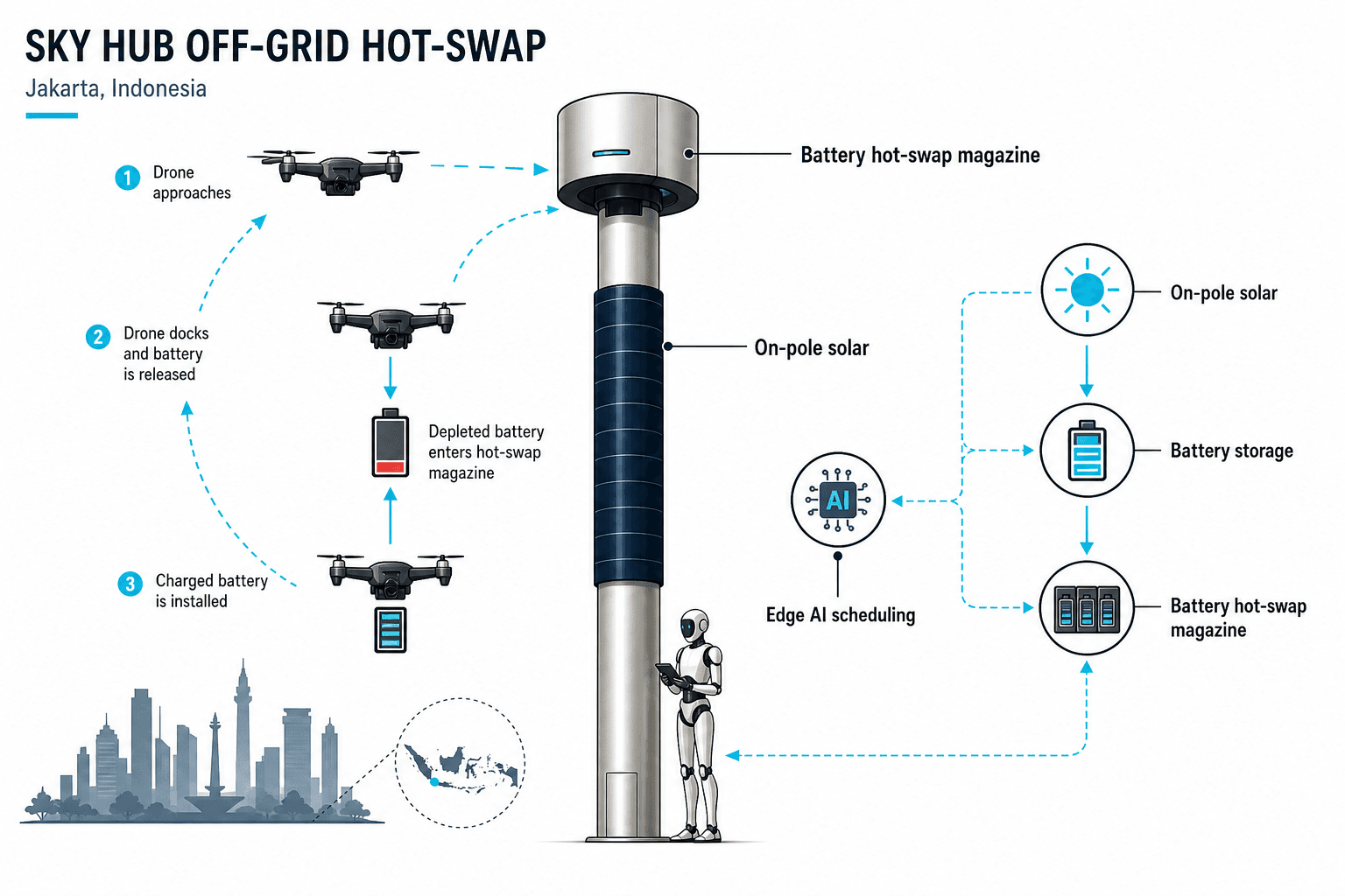
SOLARTODO Sentinel City AI Pole configuration
- Product line: SOLARTODO Sentinel City AI Pole, city-ai-pole / physical-AI urban edge node.
- Deployment scale: approximately 73 units, project-based custom configuration, subject to engineering confirmation.
- Spacing assumption: approximately 40 m between nodes, equal to about 2.9 km of linear coverage before site adjustments.
- Pole function: pure smart pole for sensing, compute, energy storage, drone operations and robot operations; no lighting system.
- Energy architecture: fully off-grid node with on-pole solar replenishment and battery storage; no city, site or grid power dependency.
- Solar replenishment layer: about 15 m² of vertical wrapped flexible CIGS thin-film, about 2.4-2.7 kWp nameplate.
- Realistic solar output reference: about 0.8-1.1 kW DC clear-sky peak and 6-9 kWh/day in a high-irradiance region; Jakarta yield should be verified with local shading and rainfall data.
- Storage class: 5-20 kWh-class battery buffer, sized by drone sortie frequency, robot duty cycle, sensors, compute load and weather reserve.
- Edge compute: Jetson-class module for local inference, task scheduling and event processing.
- Perception scope: anonymous vehicle count, crowd density, intrusion detection and perimeter awareness; no active face-recognition or licence-plate-recognition claim.
- Environmental monitoring: wind speed, wind direction, temperature, humidity, atmospheric pressure, noise, PM10, PM2.5 and illuminance.
- Drone functions: launch, patrol, inspection, return, task redeployment and automated battery hot-swap through a multi-bay magazine.
- Robot functions: autonomous patrol, alarm response, inspection, air-ground coordination and return-to-base wireless charging.
- C-UAS coordination: detection, tracking and human-authorized non-lethal response using soft aerial net-capture or close-approach deterrence; radar may be an optional partner-sensor input, not pole hardware.
- Data handling: raw sensor and video data remain on the pole; only de-identified event and status metadata leaves the site.
- Indonesia review basis: BSN SNI 0225 / PUIL 2020 for electrical installation principles and relevant IEC / ITU smart-city interoperability references.
According to ITU-T Y.4223 (2023), smart-city systems require sensing, infrastructure management, data processing and security capabilities across urban services. ITU-T states, “The systems of SC&C are interconnected through ICT,” which supports specifying Sentinel nodes as interoperable field infrastructure rather than isolated devices. For Jakarta, that means the common operating picture should integrate event metadata, maintenance status and authorized response actions across all 73 nodes.
Implementation Approach
A Jakarta rollout should be phased across surveys, permits, CKD logistics, foundations, pole erection, commissioning and privacy validation over roughly 16-28 weeks.
The first phase is route and site confirmation. A 73-node plan at 40 m spacing should be walked and surveyed against flood records, road widths, underground utilities, telecom backhaul options, drainage structures and emergency-access lanes. In Jakarta, the survey should explicitly mark coastal corrosion exposure, low-lying road segments, high-pedestrian-density areas, and narrow construction access.
The second phase is authority coordination and procurement packaging. Relevant counterparties may include DKI Jakarta agencies, local public-works offices, area managers for ports or industrial estates, and PLN coordination teams where works occur near 150/20 kV infrastructure. The product remains off-grid, but installation still requires safe work procedures, grounding review, civil approvals and traffic management.
The third phase is CKD shipping and site preparation. For 73 poles, staged deliveries reduce laydown requirements in dense city districts. Foundations should be adapted to local soil bearing, settlement risk, water table and flood elevation; North Jakarta and reclaimed coastal zones should not reuse inland foundation assumptions without geotechnical confirmation.
The fourth phase is installation and commissioning. Crews would erect the pole, configure energy storage, validate environmental sensors, test local AI workloads, verify drone and robot service loops, and connect only de-identified metadata to the command view. Commissioning should include a no-raw-video-export check, battery reserve tests, mission-abort behavior, human authorization steps for C-UAS workflows and maintenance access under wet-weather conditions.
The fifth phase is operations handover. The acceptance package should include asset register, as-built coordinates, spare-parts plan, operating roles, escalation matrix, maintenance interval, firmware policy and PDPL-oriented data-handling documentation. For a city as dense as Jakarta, operator training should include crowd-event monitoring, perimeter intrusion handling, environmental anomaly review and flood-related service dispatch.
Expected Performance & ROI
Expected ROI should be modeled from avoided truck rolls, reduced raw-video bandwidth, faster inspection cycles and battery-managed autonomy, not from lighting-energy savings.
Because the SOLARTODO Sentinel City AI Pole has no lighting hardware, ROI should not be calculated as lamp energy reduction. The main economic levers are fewer manual patrols, faster perimeter inspection, lower backhaul bandwidth, reduced remote-site power works, and improved response coordination. For a 73-node network, the highest-value zones are typically ports, campuses, industrial estates, transport interfaces and flood-prone critical-asset perimeters.
According to the World Bank (2012), the 2007 Jakarta flood inundated about 36% of the city, affected more than 2.6 million people and caused estimated losses of US$900 million. A Sentinel network does not prevent flooding, but it can help maintain local situational awareness when roads, canals and public spaces are under stress. Environmental and status metadata from 73 nodes can support quicker triage without moving raw video into a central repository.
Solar performance should be conservative. The on-pole CIGS layer is useful as a replenishment layer, but Jakarta’s clouds, rain, shadows and urban canyons will reduce output compared with high-irradiance reference regions. According to World Bank / Global Solar Atlas (2020), country and regional PV potential varies and must be assessed site by site; therefore battery sizing, sortie frequency and robot duty cycle should be confirmed through simulation before purchase order release.
A practical payback model should compare the 73-node system against an alternative using grid trenching, fixed cameras, manual drone teams, manual patrols and separate environmental stations. Typical B2B buyers should model 8-12 years of lifecycle cost, with battery replacement, cleaning, sensor calibration and connectivity fees included. Payback may be attractive where truck rolls, incident response and inspection labor are frequent, but it is site-specific and should not be quoted as a universal number.
Results and Impact
A correctly scoped 73-node Jakarta configuration would improve local awareness across about 2.9 km while keeping high-volume raw data on each pole.
The primary impact is operational continuity in locations where grid work, trenching or constant operator presence is expensive or disruptive. Fully off-grid Sentinel nodes reduce dependence on municipal power availability and avoid new continuous site-power requirements. That is especially relevant for waterfront corridors, security perimeters and temporary expansion zones where civil works face flooding, congestion or permit friction.
The second impact is data discipline. Instead of streaming every camera frame to a central system, each SOLARTODO node processes raw feeds locally and emits event metadata. This lowers bandwidth demand, reduces central storage exposure and better aligns with Indonesia’s privacy expectations without overstating legal certification.
The third impact is field automation. Drone battery hot-swap, mission scheduling, robot patrol and environmental monitoring can be coordinated from the same operating picture. C-UAS workflows remain non-lethal and human-authorized, with response limited to detection, tracking, command coordination, soft aerial net-capture or close-approach deterrence.
Comparison Table
The 73-node Jakarta plan differs from fixed CCTV, grid-tied smart poles and manual patrols across power, data, autonomy and resilience metrics.
| Option | Power model | Data model | Mobility functions | Jakarta fit | Key limitation |
|---|---|---|---|---|---|
| SOLARTODO Sentinel City AI Pole | Fully off-grid, 5-20 kWh storage plus on-pole solar replenishment | Raw data processed locally; de-identified metadata leaves pole | Drone launch, battery hot-swap, robot patrol, human-authorized C-UAS coordination | Strong for 73 nodes over about 2.9 km of flood-prone or coastal perimeter | Requires engineering confirmation of duty cycle and shading |
| Conventional fixed CCTV pole | Usually grid or site-power dependent | Often streams video to central storage | None unless separate systems are added | Useful for static observation points | Higher bandwidth and storage exposure |
| Generic smart pole with utilities | Often grid-connected with mixed loads | Varies by vendor | Usually limited unless robotics are integrated separately | Works in managed districts with stable power | Not ideal where trenching or site power is constrained |
| Manual patrol plus ad hoc drone team | Human and vehicle dependent | Reports generated after patrol | Drone flights require on-site staff | Flexible for occasional inspection | Slow response and high recurring labor |
Pricing & Quotation
SOLARTODO structures quotation for 73-node Jakarta projects by FOB Supply, CIF Delivered and EPC Turnkey tiers, with final pricing dependent on engineering scope.
SOLARTODO offers three pricing tiers for this product line: FOB Supply (equipment ex-works China), CIF Delivered (including ocean freight and insurance), and EPC Turnkey (fully installed, commissioned, with 1-year warranty). Volume discounts are available for large-scale deployments. Configure your system online for an instant estimate, or request a custom quotation from our engineering team at [email protected].
For a city-ai-pole project, quotation inputs should include the 73-unit count, 40 m spacing assumption, foundation class, flood-elevation requirement, corrosion exposure, storage capacity, drone sortie profile, robot duty cycle, communications method, command-view integration and acceptance tests. Technical buyers can also review the SOLARTODO solutions page before submitting drawings through contact us.
Frequently Asked Questions
The following 10 FAQs cover Jakarta configuration, installation, maintenance, payback, warranty and EPC quotation boundaries for a 73-node Sentinel plan.
Q1: Is the SOLARTODO Sentinel City AI Pole a smart streetlight? No. The SOLARTODO Sentinel City AI Pole is a pure smart pole with no lighting system, no lamp head and no streetlight energy-savings claim. Its role is local sensing, edge AI, environmental monitoring, drone operations, robot service and human-authorized response coordination for districts, ports, campuses and critical-infrastructure perimeters.
Q2: Why is Jakarta suited to an off-grid city AI pole configuration? Jakarta has a 32 km northern coastline, 13 river mouths and flood-prone lowlands, so avoiding new site-power dependence can simplify resilient deployment. The pole uses battery storage with on-pole solar replenishment, meaning it does not require grid, city or site power for normal operation after commissioning.
Q3: What would approximately 73 units cover at 40 m spacing? At 40 m spacing, approximately 73 units would cover about 2.9 km before allowances for intersections, restricted zones, gates, bridges and utility conflicts. Final node count should be confirmed through route survey, blind-spot analysis, service access review and local permitting constraints in the selected Jakarta district.
Q4: What is the expected deployment timeline for Jakarta? A typical 73-node Jakarta program would require about 16-28 weeks from survey to handover, depending on permits, foundations, CKD logistics, traffic windows and wet-season constraints. Dense old-town roads, port access rules, high water table and coastal corrosion specifications can extend civil preparation and commissioning time.
Q5: How should ROI and payback be calculated? ROI should be modeled against manual patrol labor, truck rolls, grid trenching, fixed-camera bandwidth, separate drone teams and standalone environmental stations. Payback is site-specific; buyers should model 8-12 years of lifecycle cost, including battery replacement, cleaning, calibration, connectivity, operator training and spare parts.
Q6: What maintenance does a Jakarta Sentinel pole need? Maintenance should include enclosure checks, drainage inspection, corrosion review, solar-surface cleaning, battery health checks, sensor calibration, drone bay inspection, robot charging verification and firmware control. Coastal sites and flood-prone areas should use shorter inspection intervals than inland campuses because salt air, humidity and standing water increase degradation risk.
Q7: Does raw video leave the pole? No. The recommended SOLARTODO Sentinel architecture processes raw video and sensor feeds locally on the pole. Only de-identified event and status metadata should leave the node, such as anonymous counts, environmental readings, alarm category, battery state, mission status and maintenance diagnostics, supporting a PDPL-oriented data posture.
Q8: How does Sentinel compare with conventional CCTV poles? Conventional CCTV poles usually depend on fixed power and central video streaming, while Sentinel combines off-grid storage, local AI, drone service, robot patrol and environmental sensing in one node. CCTV can be cheaper for static observation, but Sentinel is stronger where autonomy, lower raw-data exposure and resilient field operations matter.
Q9: What does EPC Turnkey include for quotation purposes? EPC Turnkey generally covers final engineering, delivery coordination, foundations, installation, commissioning, acceptance testing and a 1-year warranty as stated in SOLARTODO’s quotation tier paragraph. Jakarta-specific EPC scope should define traffic control, flood-elevation design, corrosion class, communications integration, operator training and local authority documentation.
Q10: Are counter-UAS functions autonomous weapons? No. Sentinel C-UAS coordination is non-lethal and human-authorized only. Permitted workflows include detection, tracking, command coordination, soft aerial net-capture or close-approach deterrence by a friendly drone. The system must not be specified for jamming, shoot-down, destructive action, hard-kill interception or autonomous attack.
References
The references below anchor Jakarta-specific facts, Indonesian electrical context and smart-city technical framing used in this 73-node configuration guide.
- BPS-Statistics DKI Jakarta (2024): DKI Jakarta Province in Figures 2024 reports 2024 population of 10,684,946 and provides official demographic context.
- Jakarta Provincial Government (2024): Jakarta.go.id describes DKI Jakarta’s 662.33 km² area, 32 km northern coastline, 13 rivers, 2 canals, 2 floodways and hot climate profile.
- BMKG (2026): Public weather forecasts for DKI Jakarta show typical daily temperature bands in the mid-20s to mid-30s °C with high humidity.
- World Bank (2011): Jakarta Urban Challenges in a Changing Climate states that about 40% of Jakarta, mostly northern areas, lies below sea level.
- World Bank (2016): Keeping Indonesia’s Capital Safer from Floods reports 13 major rivers, North Jakarta subsidence of 15-25 cm/year in some areas, and flood-management constraints.
- PT PLN (Persero) (2022): Jakarta-Tangerang 150 kV / 150-20 kV infrastructure release documents local high-voltage and distribution-system context around Jakarta Barat.
- BSN (2020): SNI 0225-4-44:2020 / PUIL 2020 provides Indonesian electrical-installation safety requirements based on IEC 60364-4-44:2015.
- ITU-T (2023): Recommendation ITU-T Y.4223 defines smart cities and communities requirements from IoT and ICT perspectives, including sensing, data processing, interoperability and security capabilities.
- World Bank / Global Solar Atlas (2020): Solar Photovoltaic Power Potential by Country explains PV potential assessment and the need for site-specific resource evaluation.
Equipment Deployed
- 73 units SOLARTODO Sentinel City AI Pole, pure smart pole / physical-AI edge-node configuration
- Approximately 40 m node spacing, about 2.9 km indicative linear coverage before survey adjustment
- Fully off-grid battery-backed micro-station, no grid, city or site power dependency
- 5-20 kWh-class battery storage per node, sized by duty cycle and weather reserve
- About 15 m² vertical wrapped flexible CIGS solar replenishment layer, about 2.4-2.7 kWp nameplate
- Realistic high-irradiance reference output of about 0.8-1.1 kW DC clear-sky peak and 6-9 kWh/day
- Jetson-class edge AI compute for local inference, workload scheduling and event processing
- Environmental sensor set: wind speed, wind direction, temperature, humidity, pressure, noise, PM10, PM2.5 and illuminance
- Drone operations module with launch, patrol, return, task redeployment and automated battery hot-swap
- Ground robot service interface for patrol, alarm response, inspection, air-ground coordination and wireless charging
- Human-authorized non-lethal C-UAS coordination for detection, tracking, soft aerial net-capture or close-approach deterrence
- Common operating picture integration transmitting only de-identified event and status metadata