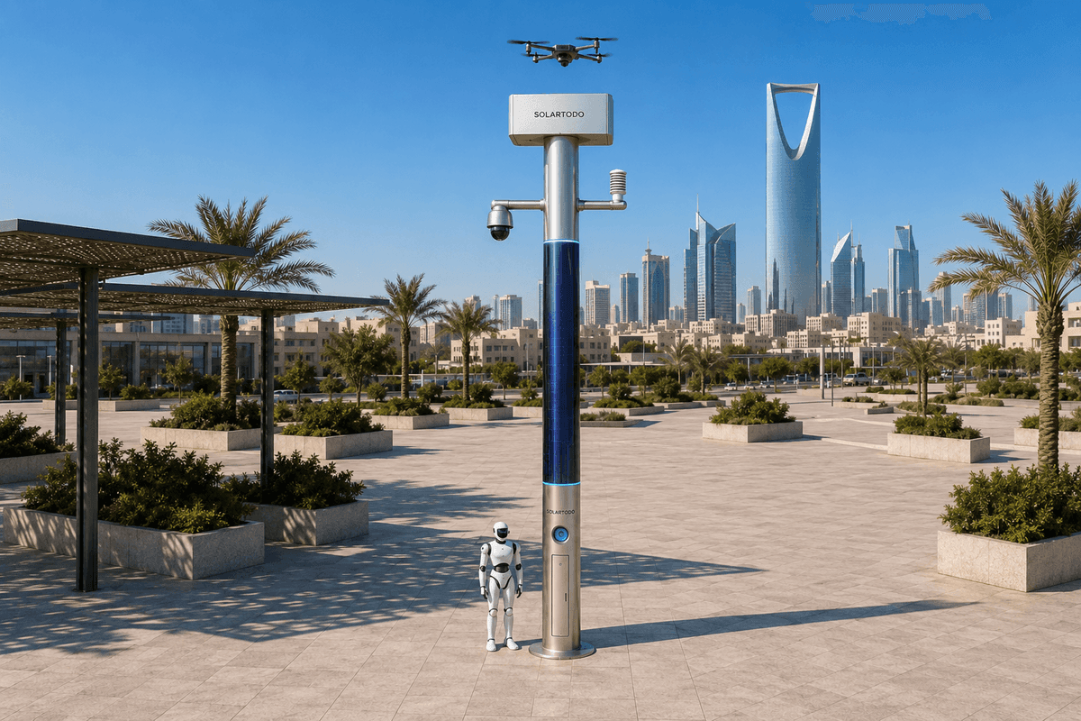
A City AI Pole is a non-lighting physical-AI edge node that combines off-grid energy, local compute, sensing, drone operations and ground robot support in one urban pole. In Bogotá, SOLARTODO Sentinel Sky Hub is proposed as a grid-mesh of edge nodes for old-town flood-season traffic incidents, keeping raw data on-pole and sending only de-identified event metadata.
1. City Task And Buyer Context
Bogotá’s old-town corridors create a demanding operating environment for any traffic-incident workflow. Narrow streets, heritage-sensitive public space, mixed pedestrian and vehicle movement, steep micro-topography, and intense rain during flood-season can turn a stalled vehicle, waterlogged curb lane, minor collision, fallen branch, or blocked utility access point into a wider availability problem. The city task in this case study is not to install a smart street asset for illumination. It is to place non-lighting physical-AI edge nodes where a power-utility operations team needs faster incident awareness, safer field dispatch and better continuity of service around critical feeders, substations, service alleys, cable chambers and flood-prone access routes.
The stakeholder is a power utility rather than a conventional traffic-only buyer. That changes the ROI logic. The utility is not primarily buying cameras; it is buying availability protection for field operations. During heavy rain, utility crews can lose time because the first report is incomplete, the closest crew lacks a verified view of the road, or a manual patrol must drive through congested old-town streets before the control room can decide whether a bucket truck, robot inspection, drone inspection or simple traffic coordination request is needed. The recurring pain point is slow manual patrol: people and vehicles are sent to find out what happened before they can solve it.
The proposed SOLARTODO Sentinel Sky Hub configuration treats each pole as an autonomous urban edge node. The deployment mode is a grid-mesh of fully off-grid poles, meaning a district-scale mesh layout of nodes, not a connection to the electrical grid. Each pole carries battery storage and 360-degree wrapped flexible CIGS thin-film solar replenishment, so the node does not depend on city, grid or site power. The business objective is to improve target incident-response availability: the percentage of time that the utility can maintain situational awareness, triage access conditions and dispatch the right resource even when rain, congestion or local power disruption would normally slow manual verification.
2. Proposed Grid-Mesh Deployment For Old-Town Traffic Incidents
The proposed Bogotá configuration places Sky Hub nodes at selected old-town intersections, utility access approaches, perimeter points around service yards, and road segments that become operational chokepoints during flood-season. Final locations would require structural, heritage, telecom, aviation, solar exposure and right-of-way engineering confirmation. The grid-mesh concept is intentionally selective: a small number of intelligent poles create overlapping awareness for priority routes rather than attempting continuous blanket coverage or claiming citywide deployment.
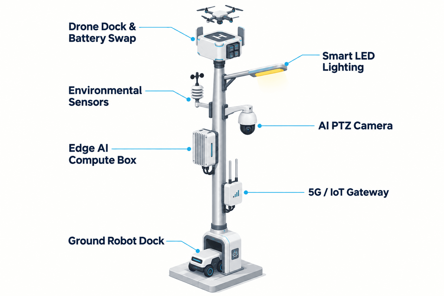
Each Sky Hub is a pure smart pole with no lighting system. Its job is to host sensing, edge AI compute, energy storage, drone operations, ground robot charging and operational coordination. The pole’s PTZ camera and local perception watch for anonymous traffic and access anomalies such as a stopped vehicle in a service corridor, crowd density near a blocked intersection, intrusion into a utility perimeter, or abnormal congestion around a worksite. The nine-in-one environmental package provides wind speed, wind direction, temperature, humidity, atmospheric pressure, noise, PM10, PM2.5 and illuminance readings, which help the utility interpret whether a traffic incident is connected to rain intensity, visibility, air quality, construction noise or storm conditions.
The deployment is designed around the operations loop of sensing, authorized assessment and response, edge-compute scheduling, and field operations and maintenance. A common-operating-picture command view receives de-identified event and status metadata from each node. Raw video and raw sensor data stay on the pole and are processed locally. That local-first design supports PDPL/LGPD-oriented data handling without claiming certification. For the utility, the COP becomes a practical operational layer: which access route is blocked, which pole has enough stored energy for a drone sortie, whether a robot can inspect a lower-risk area near the pole base, and whether a human supervisor should authorize a drone dispatch or coordinate with city traffic responders.
3. Edge Compute As The Availability Engine
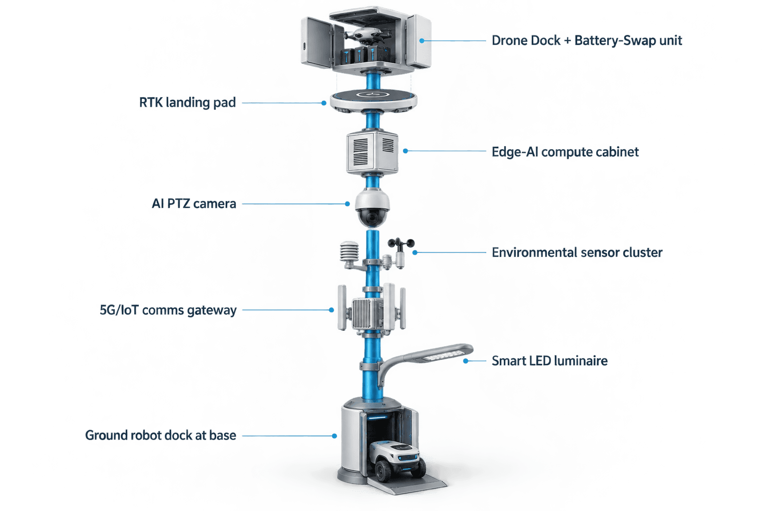
The module focus for this Bogotá case is edge compute. In a slow-manual-patrol model, the control room waits for a human observer, phone report, mobile crew photo or third-party notification. The proposed Sky Hub mesh changes the sequence. The on-pole edge module performs local inference, filters routine motion from actionable events, scores the incident type and schedules the next workload directly on the node. Only the resulting event summary, status update and mission log metadata need to leave the pole.
For a flood-season traffic incident, the pole can classify a blocked access lane, detect crowd density near a transformer-adjacent sidewalk, recognize perimeter intrusion around a utility work zone, and correlate the event with local environmental conditions. It can then queue a drone task for an elevated route inspection, hold it if wind conditions are outside the local rule set, or request human authorization before launch. If a ground robot is assigned, the pole can schedule a short patrol from the base, coordinate air-ground awareness, and return the robot to wireless charging. These are mature physical-AI workflows, but the deployment case remains a proposed configuration; target KPIs must be measured during commissioning and operations rather than stated as achieved results.
The drone operations workflow supports launch, regional patrol, inspection, return and task redeployment without an operator standing at the pole. A multi-bay rear-service battery magazine performs automated battery exchange after landing, allowing several consecutive sorties within the local duty cycle. The same edge compute stack manages route planning, charge or swap state, task queues, fleet health and mission logs. When an unauthorized drone is detected and tracked, the pole can coordinate a friendly drone for non-lethal, human-authorized soft aerial net-capture or close-approach deterrence. Radar is not treated as pole hardware; any radar signal would be an optional partner-sensor input integrated under local policy.
4. Off-Grid Energy And Duty-Cycle Reality
Sky Hub is proposed as a fully off-grid micro-station. That point matters to a power utility because the node should not consume the utility’s own distribution capacity or require street-side site power. Each pole combines battery storage with on-pole solar replenishment. The reference cylindrical body uses approximately 15 square meters of 360-degree wrapped flexible CIGS thin-film over a vertical body around 8 meters tall and 0.6 meters wide, with about 2.4 to 2.7 kWp nameplate capacity. Nameplate capacity is not a field-output promise.
A vertical cylinder collects direct sun mainly through the sun-facing projection, not the entire wrap at the same time. In a high-irradiance reference region, realistic clear-sky output is roughly 0.8 to 1.1 kW DC peak, typically peaking mid-morning or mid-afternoon rather than exactly at noon, and about 6 to 9 kWh per day. Bogotá’s site-specific yield would need local solar modeling, shading review, rain-season assumptions and final engineering confirmation. The key claim is therefore not unlimited pure solar self-sufficiency. The CIGS layer is a supplemental replenishment system for a battery-backed, fully off-grid physical-AI node.
The operational design uses 5 to 20 kWh-class storage for the Bogotá traffic-incident configuration, with final storage sized to duty cycle. Edge inference, sensing and communications run as baseline workloads. Higher-power drone sorties, battery exchange, robot patrols and extended event recording are scheduled against state of charge, weather, mission priority and availability targets. During flood-season, the COP can rank poles by energy state and field importance: maintain awareness at priority access corridors first, defer noncritical patrols when storage is low, and reserve drone capacity for incidents that affect utility restoration routes or critical infrastructure access.
5. ROI Analysis And Evaluation Plan
The ROI frame is availability, not a claimed reduction in cost already achieved. A Bogotá power-utility buyer can recompute value by comparing the proposed Sky Hub grid-mesh against today’s manual patrol workflow. The first planning variable is patrol substitution: how many routine verification trips can be replaced by edge-confirmed incident metadata, a short drone inspection or a robot patrol near the pole base? The second variable is dispatch precision: how often can the control room send the right crew, tool and route on the first dispatch because the edge node has already classified the obstruction and environmental context?
A third variable is service continuity during flood-season. Fully off-grid operation means the node remains designed to operate without city, site or grid power. The value is strongest where old-town congestion, rain and heritage street geometry make every avoided exploratory patrol meaningful. The fourth variable is data-governance confidence. Because raw video and raw sensor data stay on the pole, and only de-identified event or status metadata leaves the node, the utility can plan a PDPL/LGPD-oriented architecture that limits unnecessary data movement while still giving operators a common operating picture.
The evaluation plan should define target availability before deployment: percentage of priority hours with node telemetry online, percentage of traffic incidents that receive an edge-generated event summary, drone or robot task readiness during defined weather windows, and percentage of field dispatches supported by local evidence before crew arrival. These should be treated as commissioning and operating KPIs, not marketing results. A credible first phase would avoid invented rollout quantities or coverage claims. It would instead select representative old-town chokepoints, confirm energy yield and mounting conditions, validate human authorization rules, and compare the workflow against manual patrol baselines over a defined flood-season evaluation period.
System Configuration
| Parameter | Configuration |
|---|---|
| Pole category | SOLARTODO Sentinel Sky Hub pure non-lighting city AI pole / physical-AI edge node |
| Deployment mode | Selective old-town grid-mesh of fully off-grid nodes; no city, site or grid power connection |
| Edge AI compute | Jetson-class on-pole inference cabinet with local workload scheduling and event metadata export only |
| Energy system | 5-20 kWh-class battery storage with ~15 m² 360° wrapped flexible CIGS replenishment, ~2.4-2.7 kWp nameplate |
| Sensing package | AI PTZ for anonymous vehicle count, crowd density, intrusion and perimeter awareness plus nine-parameter environmental monitoring |
| Air-ground operations | Autonomous drone launch, patrol, return, rear-service battery hot-swap and ground robot patrol with base wireless charging |
| Command view | Common-operating-picture dashboard for sensing, authorized response, edge scheduling, mission logs and maintenance status |
How It Works
- On-pole PTZ and environmental sensors flag a flood-season traffic anomaly near a utility access route.
- Edge AI classifies the event locally, scores operational impact and keeps raw video and sensor data on the pole.
- The COP receives de-identified event metadata, node energy state and recommended response options.
- A human supervisor authorizes a drone inspection, robot patrol or field-crew dispatch based on the event packet.
- The pole schedules the mission, records mission logs, updates fleet health and returns assets to charging or battery exchange.
- The utility reviews incident metadata against target availability, patrol substitution and dispatch-precision KPIs.
Planning Assumptions (Indicative)
Illustrative planning inputs a buyer can recompute — target metrics, not achieved results. Subject to final engineering confirmation.
| Metric | Planning assumption | Indicative value |
|---|---|---|
| Inspection labor | Drone or robot verification replaces routine manual traffic-incident confirmation patrols at selected old-town utility access points | ~8-12 patrols/week automated for planning comparison |
| Availability window | Priority flood-season corridors require active edge status and event metadata during defined operating hours | Target 95%+ telemetry availability during priority hours |
| Dispatch precision | Control room receives edge-classified incident summaries before sending utility crews | Target 1 verified event packet before first dispatch |
| Drone readiness | Multi-bay battery magazine supports consecutive short inspection sorties within local weather and authorization rules | ~3-5 short sorties per charged magazine cycle |
| Manual escalation | Human supervisor authorizes drone launch, C-UAS mitigation coordination and any regulated response step | 100% human-in-the-loop for regulated actions |
| Energy budget | High-power drone and robot tasks are scheduled against storage state, weather and mission priority | 5-20 kWh storage class sized by final duty cycle |
Deployed Equipment
- SOLARTODO Sentinel Sky Hub non-lighting pole body
- 360° wrapped flexible CIGS thin-film solar skin
- Battery-backed off-grid power cabinet with BMS and MPPT controls
- Jetson-class edge AI compute cabinet running OTATODO
- AI PTZ camera for local anonymous perception
- Nine-parameter environmental monitoring package
- Drone hangar with multi-bay rear-service battery magazine
- Ground robot wireless charging interface at pole base
Frequently Asked Questions
Is this Bogotá case study describing an existing citywide rollout?
No. This is a proposed and illustrative deployment configuration for a Bogotá old-town traffic-incident use case, written for planning and ROI analysis. It does not claim a named customer, installed quantity, coverage area, certification, award, achieved latency or measured detection rate. All KPIs should be treated as target evaluation metrics subject to final engineering confirmation.
Why would a power utility buy a city AI pole for traffic incidents?
For a power utility, traffic incidents matter when they block crews, delay access to feeders or substations, complicate storm restoration, or create safety uncertainty around field work. The proposed Sky Hub mesh is framed around operational availability: faster local awareness, better dispatch evidence and fewer exploratory manual patrols during flood-season, not generic smart-city visibility.
Does Sky Hub require city power or the utility grid?
No. The proposed node is fully off-grid, combining battery storage with 360-degree wrapped flexible CIGS solar replenishment. The solar layer is not presented as unlimited energy. It is a supplemental replenishment layer, while storage buffers baseline sensing, edge compute, communications and higher-power drone or robot tasks according to duty cycle.
What data leaves the pole in this configuration?
Raw video and raw sensor data stay on the pole and are processed locally by the edge compute module. The COP receives de-identified event metadata, status data, energy state, mission logs and maintenance indicators. This is PDPL/LGPD-oriented architecture language, not a claim that the deployment is already certified under any specific regulation.
What does the drone battery hot-swap capability change operationally?
After a drone returns to the pole, a rear-service multi-bay magazine can exchange the depleted pack for a charged pack and support relaunch within the approved task queue. This helps a utility plan several short verification sorties during a flood-season incident window without placing an operator at the pole, while still respecting weather, energy and authorization limits.
How are ground robots used in the old-town traffic-incident scenario?
A humanoid or service robot can perform short autonomous patrols near the pole base, inspect a blocked approach, check a utility work-zone perimeter, support alarm response and coordinate with drone observations. After the task, it returns to the base for wireless charging. The robot is part of the air-ground operations loop, not a substitute for authorized field crews.
How is Counter-UAS coordination bounded in this case study?
The pole may detect and track an unauthorized drone and coordinate its own friendly drone for non-lethal, human-authorized soft aerial net-capture or close-approach deterrence. The workflow separates detection, assessment, authorization and action. Radar is not built into the pole; if used, it would be an optional partner-sensor input governed by local policy.
What should the utility measure to judge ROI?
The practical measures are target availability of node telemetry during priority hours, number of manual verification patrols avoided, share of dispatches supported by edge-confirmed event packets, drone or robot readiness under defined weather windows, and reduction in incomplete incident reports. These are planning metrics to be recomputed by the buyer, not claimed achieved outcomes.
Explore Further
- City AI Pole / smart streetlight product line
- More smart-city deployment cases
- Talk to our engineering team
Planning a similar physical-AI deployment for streets, campuses or public spaces? Request an engineering consultation