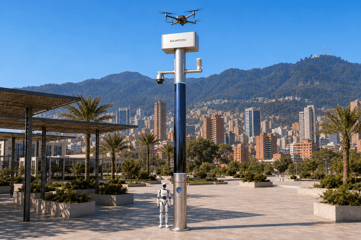
A City AI Pole is a physical-AI urban edge node combining local computing, sensing, communications and autonomous drone and ground robot operations. SOLARTODO Sentinel’s Sky Hub is a fully off-grid, non-lighting pole powered by battery storage with solar replenishment. This proposed Bogotá configuration supports transport-authority flood assessment along a campus perimeter while keeping raw data on the pole.
1. Incident brief: a flooded approach during a night-economy peak
The review begins with an illustrative incident: during a wet-weather night-economy peak, standing water appears beside the access road of a transport operations campus. Returning service vehicles, staff movements and surrounding evening activity compete for limited access. The transport authority needs to establish whether the perimeter route remains usable, where inspection personnel should approach and whether another assessment is necessary before normal circulation resumes.
Bogotá provides a specific river-network context. The Salitre, Fucha and Tunjuelo rivers discharge into the Bogotá River, connecting urban drainage concerns across different catchments. That geography supports a catchment-aware assessment rather than treating every flooded entrance as an isolated obstruction. It does not establish the flood exposure of any particular campus. Source: Bogotá environment authority.
The proposed deployment places SOLARTODO Sentinel Sky Hub at an engineered position on the campus perimeter, with access to the approach road and relevant drainage interfaces. Final placement would depend on surveyed flood levels, ground conditions, flight clearances and maintenance access. No actual customer, installation count or historical incident is asserted here.
The central operational problem is drone endurance. An initial inspection can identify a possible blockage, yet conditions may change before a crew reaches it. Repeated manual launches and battery handling consume staff time. The incident review therefore asks whether a pole-based communications and servicing loop can sustain useful reassessment with fewer routine interventions. Operating expenditure is evaluated through staff effort, avoidable attendance and service workload, rather than an assumed reduction in flooding.
2. Detection review: communications make observations actionable
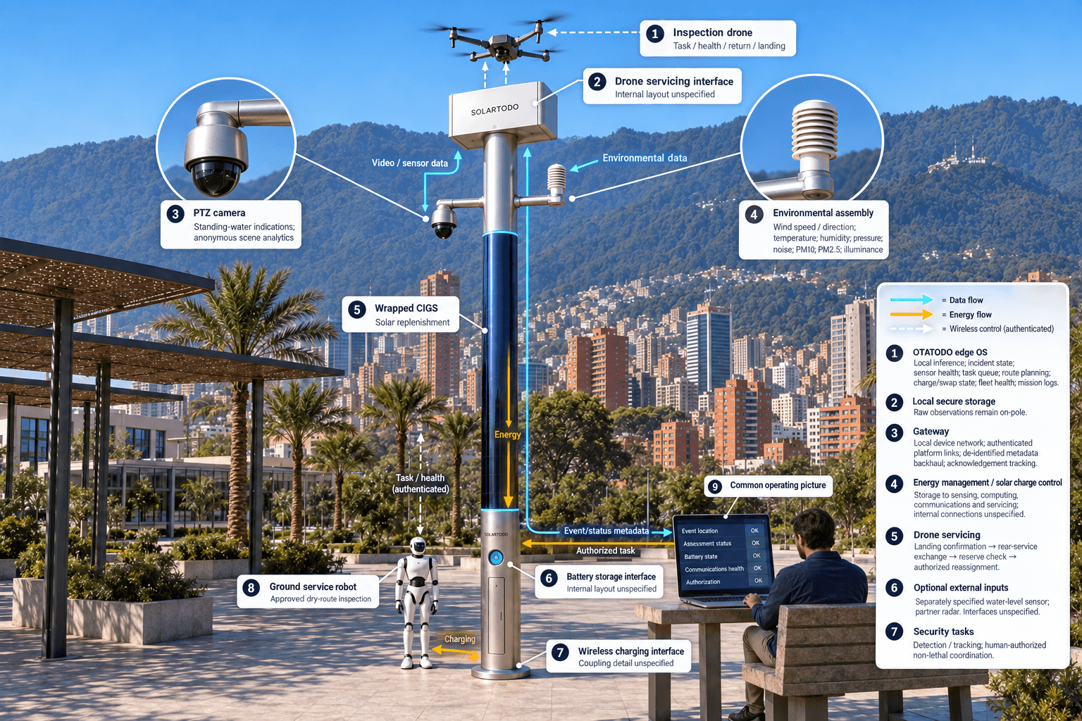
At the opening stage, the pole’s PTZ camera supplies local perception of standing-water indications, anonymous vehicle counts, crowd density, intrusion and perimeter conditions. A visual indication prompts assessment; it does not establish water depth or certify that a route is safe. The environmental module adds wind speed, wind direction, temperature, humidity, atmospheric pressure, noise, PM10, PM2.5 and illuminance. Direct water-level measurement would require a separately specified sensor input.
Communications are the configuration’s organizing module. The proposed node combines a local device network, authenticated drone and robot links, and resilient wireless backhaul for permitted event metadata. Engineering must establish antenna positions, perimeter obstructions, link availability and appropriate separation between operational control and routine reporting. Additional connectivity carries its own energy and maintenance costs, which belong in the operating model.
OTATODO, the on-pole edge OS, associates observations with an incident identifier, sensor health and task state. Raw video and sensor data stay on the pole and are processed locally. Only de-identified event and status metadata may leave it. The remote common-operating-picture command view therefore receives an event location, assessment status, battery state, communications health and authorization requests rather than a raw-video stream.
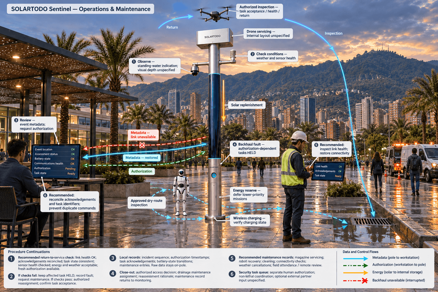
This distinction matters during a busy evening. Dispatchers need a coherent incident state without repeatedly requesting field updates. When backhaul becomes unavailable, local records preserve the sequence and approved local functions follow their operating rules. A task requiring fresh human authorization remains held until that authorization is available. Restoring connectivity must reconcile acknowledgements and task identifiers without accidentally repeating a command.
3. Response review: manage endurance through the complete sortie cycle
After an authorized operator assesses the alert, the node schedules a drone inspection within the approved operating envelope. The drone launches, inspects the assigned perimeter sector and returns for servicing. Communications carry task acceptance, aircraft health, return status and landing confirmation, allowing the edge scheduler to distinguish an unfinished inspection from a completed mission awaiting review.
The endurance intervention occurs after landing. A multi-bay battery magazine performs an automated rear-service battery exchange, giving the landed drone a charged pack for another assigned sortie. Multiple bays support several consecutive sorties, subject to available charged packs, charging energy, weather and equipment condition. This reduces the need for an operator beside the pole; it does not extend the flight duration of an individual battery indefinitely.
Drone operations management links route planning, the charge/swap state machine, task queues, fleet health and mission logs. Before redeployment, the scheduler checks the remaining energy reserve and whether the next observation would answer a useful operational question. Repeating an unchanged route simply because a pack is available would add wear without necessarily improving the transport decision.
A ground service robot complements the aerial inspection. It can patrol an approved dry route, inspect an accessible asset or respond to an alarm, then return to the pole base for wireless charging. The shared command view coordinates air and ground assignments so both platforms do not investigate the same point unnecessarily. Floodwater, unstable surfaces and public movement constrain robot routing. Decisions about access restrictions, maintenance dispatch and reopening remain with authorized personnel, supported by local observations and recorded task outcomes.
4. Resource review: off-grid energy and response authority
Sky Hub is a PURE smart pole with no lighting system. Its proposed cylindrical body is approximately 8 m tall and 0.6 m wide, carrying about 15 m² of 360°-wrapped flexible CIGS thin-film solar. The approximately 2.4–2.7 kWp nameplate rating describes standardized module capacity; it is not the cylinder’s expected operating output.
Only the sun-facing projection intercepts direct sunlight at a given moment. In a high-irradiance region such as Saudi Arabia, realistic clear-sky production is roughly 0.8–1.1 kW DC peak and approximately 6–9 kWh per day, with peaks around mid-morning or afternoon rather than noon. Those reference figures are not a Bogotá yield forecast. Local cloud, shading, mounting geometry and seasonal conditions require a site-specific energy assessment.
The node is fully off-grid, with no grid, city or site power connection. Solar provides supplemental replenishment; 5–20 kWh-class battery storage buffers computing, communications, battery exchange charging and robot charging. Stored energy is finite. The scheduler must reserve energy for essential sensing and communications, defer lower-priority missions when necessary and account for replenishing drone packs. The storage selection and achievable duty cycle remain subject to final engineering confirmation.
The same command architecture governs exceptional security events. Sentinel supports unauthorized-drone detection and tracking, followed by human-authorized coordination of its own friendly drone for soft aerial net-capture or close-approach deterrence. Any mitigation remains non-lethal and subject to applicable authorization. Radar is not built into the pole; an optional partner sensor may supply an input. Flood-response tasks and security tasks share resource scheduling, while each retains its own approval requirements.
5. Close-out review: evaluate operating effort against a defensible baseline
The proposed incident closes when the transport authority records its access decision, assigns any drainage maintenance and determines whether further observation is needed. The common operating picture connects sensing, authorized assessment and response, edge-compute scheduling, and field operations and maintenance. It should show the reasoning behind a reassessment request as clearly as the resulting drone task.
For procurement, the principal evaluation question is whether this loop reduces routine operating effort without transferring unmeasured work elsewhere. Candidate metrics include staff minutes spent on battery attendance, duplicate inspection requests, time spent reconciling incident records and scheduled maintenance effort. Communications performance matters because missing acknowledgements can create unnecessary calls or site visits. Successful message delivery alone does not establish an operating-cost benefit.
The illustrative calculations below establish recomputable workloads, not achieved savings. An evaluation should compare the same task definitions before and after deployment, record weather cancellations and distinguish remote supervision from personnel physically attending the pole. Battery-magazine servicing, robot recovery, cleaning, connectivity management and local evidence review must remain visible in the workload ledger. Equipment availability should be assessed alongside energy reserve and unresolved communications faults.
Acceptance evidence would include locally retained incident records, authorization timestamps, task acknowledgements, battery-state transitions and maintenance entries. External reports may contain only de-identified event and status metadata; raw source material remains on the pole. The local-processing design is PDPL/LGPD-oriented, without asserting certification or established Colombian compliance. The transport authority must confirm applicable local requirements separately.
This is a proposed Bogotá application of Sentinel’s mature, in-service capability set. It claims no local deployment history or measured outcome. Procurement decisions should follow site engineering, authorized operational evaluation and a transparent comparison of operating effort.
System Configuration
| Parameter | Configuration |
|---|---|
| Pole and placement | PURE non-lighting Sky Hub pole; approximately 8 m tall × 0.6 m wide cylindrical body; campus-perimeter placement subject to flood and structural engineering. |
| Off-grid energy | Approximately 15 m² wrapped flexible CIGS, 2.4–2.7 kWp nameplate; 5–20 kWh-class storage; no external power connection; site-specific duty-cycle assessment. |
| Edge processing and privacy | On-pole AI inference and OTATODO workload scheduling; raw video and sensor data retained on-pole; de-identified event/status metadata export only. |
| Communications | Local device gateway, authenticated drone/robot links and resilient wireless backhaul; acknowledgement tracking and local event buffering. |
| Sensing | PTZ camera with anonymous scene analytics; wind speed, wind direction, temperature, humidity, pressure, noise, PM10, PM2.5 and illuminance. |
| Drone and robot servicing | Drone landing interface with automated rear-service battery exchange and multi-bay magazine; ground service robot with base wireless charging. |
| Command and response | Common operating picture with human authorization, mission queues and audit records; non-lethal counter-UAS coordination; optional partner-sensor inputs. |
How It Works
- On-pole perception flags possible standing water at the campus approach.
- Local inference associates the alert with sensor health, conditions and incident status.
- An authorized operator reviews de-identified metadata and approves an inspection task.
- The edge scheduler checks communications, weather and energy before dispatching the drone or robot.
- Returning platforms complete battery exchange or wireless charging before any approved reassignment.
- Raw observations remain on-pole while de-identified decisions, task states and maintenance events update the command view.
Planning Assumptions (Indicative)
Illustrative planning inputs a buyer can recompute — target metrics, not achieved results. Subject to final engineering confirmation.
| Metric | Planning assumption | Indicative value |
|---|---|---|
| Manual battery-attendance baseline | ILLUSTRATIVE ONLY: assume 4 battery-attendance visits per week, 20 staff-minutes each, over 4 weeks; validate actual attendance. | 4 visits/week × 20 staff-minutes/visit × 4 weeks = 320 staff-minutes of baseline workload. |
| Remote incident-review workload | ILLUSTRATIVE ONLY: assume 8 incident reviews per week at 10 staff-minutes each for 4 weeks; no achieved productivity claim. | 8 reviews/week × 10 staff-minutes/review × 4 weeks = 320 staff-minutes of planned review workload. |
| Communications-fault attendance exposure | ILLUSTRATIVE ONLY: assume 2 communications-fault visits per month, each requiring 2 staff for 30 minutes; validate during evaluation. | 2 visits/month × 2 staff × 30 minutes = 120 staff-minutes/month of assumed attendance exposure. |
| Scheduled node-maintenance allowance | ILLUSTRATIVE ONLY: allow 1 maintenance visit per week involving 2 staff for 45 minutes over 4 weeks. | 1 visit/week × 2 staff × 45 minutes × 4 weeks = 360 staff-minutes of maintenance allowance. |
| Incident-record reconciliation baseline | ILLUSTRATIVE ONLY: assume 12 records per week need 5 staff-minutes of reconciliation each over 4 weeks. | 12 records/week × 5 staff-minutes/record × 4 weeks = 240 staff-minutes of baseline reconciliation effort. |
Deployed Equipment
- Proposed Sky Hub cylindrical pole with wrapped flexible CIGS solar.
- Battery storage cabinet with energy management and solar charge control.
- On-pole edge computing cabinet and communications gateway.
- PTZ camera and nine-parameter environmental sensor assembly.
- Autonomous inspection drone, landing interface and multi-bay rear-service battery magazine.
- Ground service robot and pole-base wireless charging interface.
- Local secure storage and human-authorized common-operating-picture console.
Frequently Asked Questions
Does this case describe an installed Bogotá customer deployment?
No. It is a proposed campus-perimeter configuration presented through an illustrative incident review. Sentinel’s capabilities are described as mature and in service, but no Bogotá installation, customer relationship or achieved result is asserted. Site selection, permissions, energy sizing and operational acceptance require separate confirmation.
How does the pole address drone endurance during repeated flood inspections?
The pole supports repeated sorties through automated rear-service battery exchange after landing. A multi-bay magazine provides charged packs while operations management coordinates routes, servicing and task queues. Consecutive sorties remain constrained by charged-pack inventory, replenishment energy, weather, aircraft condition and authorization; individual flight endurance is not unlimited.
Can the wrapped solar supply continuous night operations in Bogotá?
Night operations draw on stored energy. Wrapped CIGS replenishes the battery during available daylight, and high-power tasks follow an engineered duty cycle. The cited 6–9 kWh daily reference concerns clear-sky conditions in a high-irradiance region, not Bogotá. Local energy modelling must establish sustainable workload and reserve requirements.
What can the transport authority receive remotely?
The remote command view may receive de-identified event and status metadata, including incident location, authorization state, task progress, equipment health and battery status. Raw video and sensor data stay on the pole for local processing. Review procedures must preserve that boundary, including during troubleshooting and incident close-out.
Does the pole determine whether a flooded road is safe or automatically counter an unauthorized drone?
Road-access decisions remain with authorized personnel; visual observations alone do not certify safe passage or water depth. Counter-UAS mitigation also requires human authorization and is limited to non-lethal coordination, such as friendly-drone soft aerial net-capture or close-approach deterrence. Radar is only an optional external sensor input.
Explore Further
- City AI Pole / smart streetlight product line
- More smart-city deployment cases
- Talk to our engineering team
Planning a similar physical-AI deployment for streets, campuses or public spaces? Request an engineering consultation