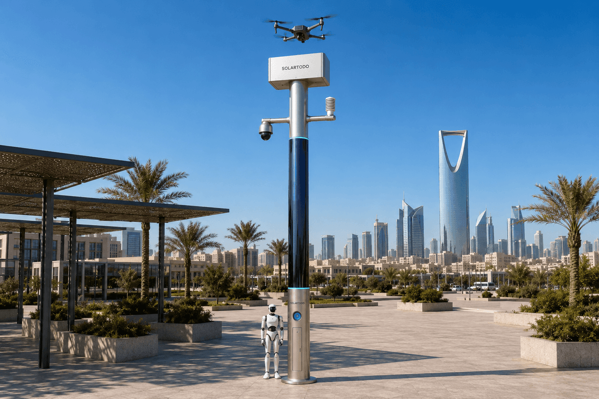
A City AI Pole is a fully off-grid physical-AI edge node that combines local sensing, edge compute, battery-backed solar replenishment, drone operations and robot coordination in one non-lighting urban pole. In this Bangkok pilot configuration, SOLARTODO Sentinel Sky Hub supports campus-perimeter security and heatwave fire-response patrols for a cultural-tourism park operator.
1. Bangkok Pilot Context
This pilot-report case study frames a proposed SOLARTODO Sentinel Sky Hub deployment for a Bangkok cultural-tourism park operator managing a campus-style perimeter. The operating environment is familiar to large visitor attractions in Thailand: mixed pedestrian flows, landscaped areas, service roads, perimeter gates, temporary events, night maintenance windows, and heatwave periods that raise the probability of smoke, electrical faults, dry vegetation and delayed incident discovery.
The core city task is security, but the trigger scenario is fire-response during hot-season conditions. The operator’s pain point is slow manual patrol: guards and facility teams can walk or drive patrol routes, but perimeter edges, garden zones, parking margins and utility corners can remain unobserved between patrol intervals. During visitor peaks, staff attention is pulled toward crowd control and access management. At night, the same site may have fewer staff available, while the area to be checked remains the same.
The proposed deployment mode is campus-perimeter: Sky Hub nodes are positioned at selected perimeter and internal edge points where they can observe gates, fence lines, service corridors and fire-risk zones without depending on city or site power. The KPI framing is coverage, not a claim of achieved detection rate. Planning teams would evaluate how much of the perimeter patrol plan can be continuously sensed, how many patrol segments can be covered by autonomous drone sorties, and how quickly an authorized response can be dispatched after a local anomaly is scored on the pole.
This is not a product datasheet exercise. The question for the park operator is operational: how does a physical-AI edge node reduce blind intervals while respecting privacy expectations in a tourism setting? The Sentinel answer is to keep raw video and sensor data processed locally on the pole, send only de-identified event and status metadata into the common-operating-picture view, and use human-in-the-loop authorization before drone or C-UAS response actions move beyond observation.
2. Drone-Nest Operating Model
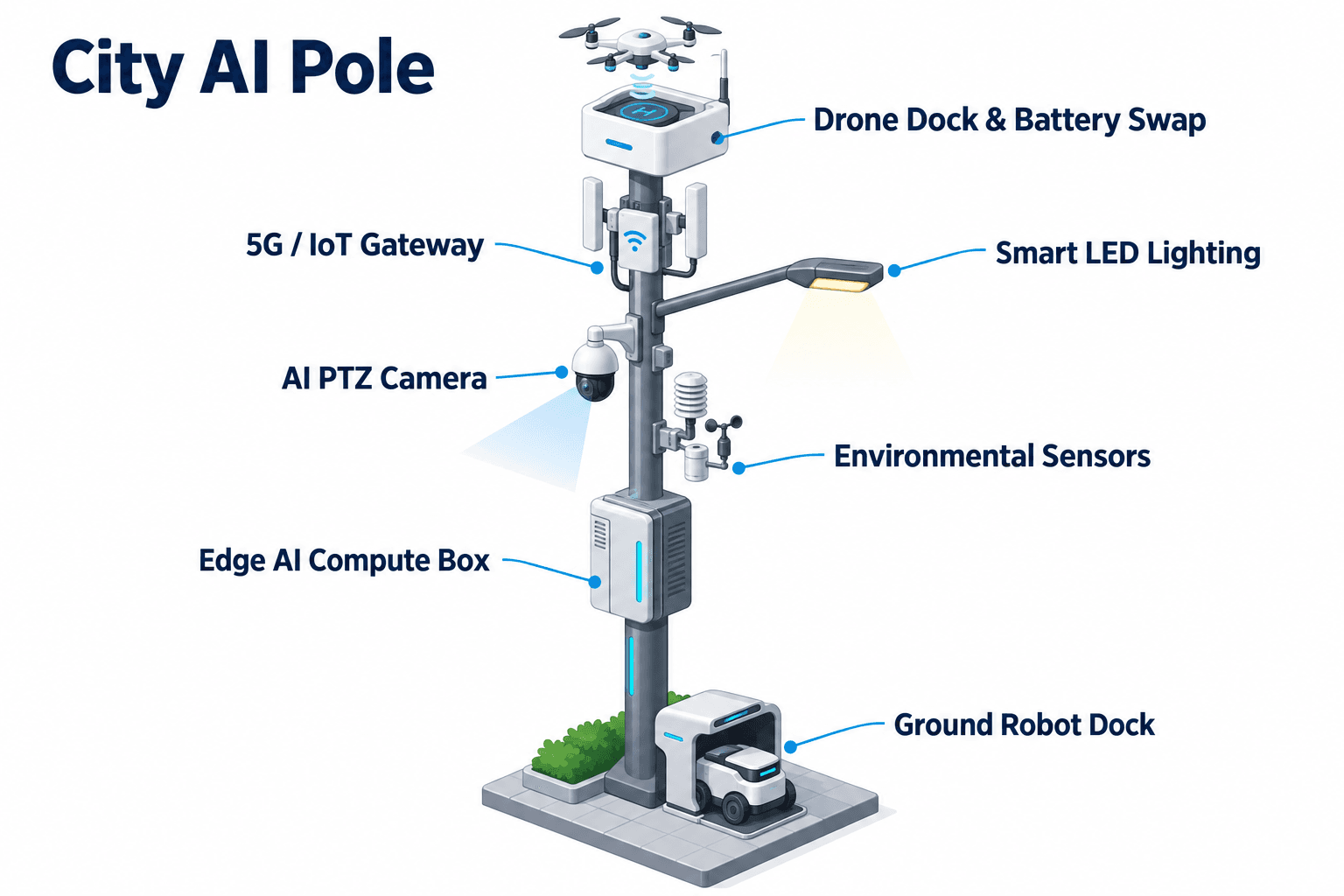
The module focus for this Bangkok configuration is the drone nest. Each Sky Hub acts as a fully off-grid micro-station: a PURE smart pole, energy store, perception point, edge-compute cabinet and autonomous drone operations node. The drone workflow is designed for patrol launch, regional inspection, return, battery exchange and task redeployment without an operator standing beside the pole.
For slow-manual-patrol reduction, the drone nest changes the rhythm of coverage. Instead of waiting for a guard to reach the far side of the park, the command desk can schedule autonomous perimeter sorties by route segment, heat-risk zone or incident priority. When the on-pole PTZ camera flags smoke-like haze, unusual crowd movement, perimeter intrusion or an abnormal service-lane condition, OTATODO schedules local workloads, records the event metadata and presents the item for authorized assessment. If the operator confirms escalation, the node can launch its friendly drone to inspect the segment from the air, stream operational status to the command view, return, exchange battery from the rear-service multi-bay magazine, and relaunch for the next assigned segment.
The hot-swap magazine is important for coverage planning. A single drone flight can inspect a segment, but several consecutive sorties are needed when a heatwave creates multiple watch areas across a large campus. The multi-bay exchange mechanism gives the landed drone a charged pack and returns it to service, while the management layer tracks route plan, charge or swap state, task queue, fleet health and mission log. The planning metric is therefore not only flight availability, but how many perimeter segments can be inspected per shift without adding a manual patrol crew.
Ground robot operations complete the air-ground loop. A humanoid or service robot can patrol paths, respond to an alarm, inspect a door, coordinate with the aerial view, and return to the pole base for wireless charging. In this proposed Bangkok use case, the drone provides rapid coverage over perimeter and landscaped sections, while the ground robot handles closer inspection where walking paths, building thresholds or service entrances require a physical presence.
3. Edge Intelligence and Privacy
A cultural-tourism site in Bangkok is a sensitive public-facing environment. Visitors expect safety, but they also expect proportional data handling. The Sentinel configuration is therefore PDPL/LGPD-oriented by design: raw video and raw sensor streams stay on the pole for local processing, while only de-identified event and status metadata may leave the pole for the command view.
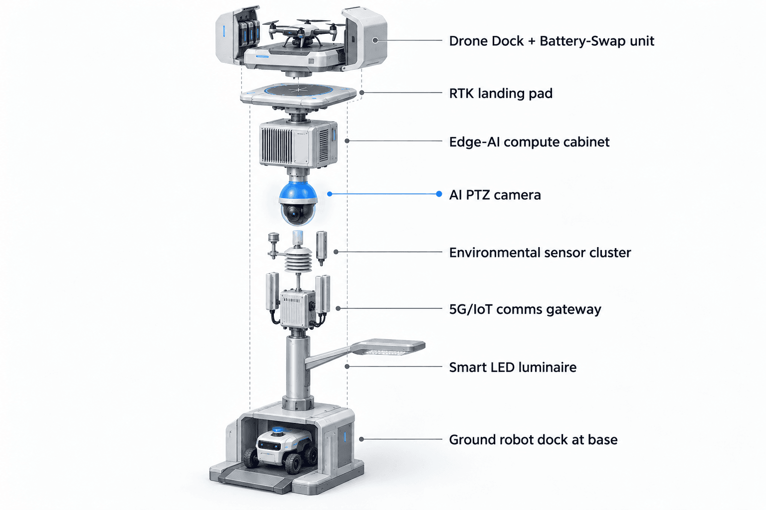
The security-sensing layer uses a PTZ camera with local perception for anonymous vehicle count, crowd density, intrusion and perimeter awareness. It does not rely on face recognition or licence-plate recognition as active deployed capabilities. Environmental monitoring adds nine operational inputs: wind speed, wind direction, temperature, humidity, atmospheric pressure, noise, PM10, PM2.5 and illuminance. In a heatwave fire-response scenario, these signals help the operator decide whether a smoke-like visual anomaly deserves immediate drone inspection, whether wind direction affects response routing, and whether a patrol task should be reprioritized toward dry landscape edges or utility zones.
Edge AI compute runs on a Jetson-class module, either Orin-class or Thor-class depending on final engineering confirmation. The compute role is practical: local inference, event scoring, mission scheduling, workload allocation and data minimization. It is not a cloud-upload model. The COP command view presents the operations loop as sensing, authorized assessment and response, edge-compute scheduling, and field operations and maintenance. This matches the “sensing to assessment to action to maintenance” pattern needed by a park operator that must coordinate security staff, facility maintenance and emergency response without turning every camera feed into a central raw-data stream.
Counter-UAS coordination is included as a non-lethal, human-authorized safety function. The pole can detect and track an unauthorized drone using its local sensing and approved optional partner-sensor inputs if integrated. It can then command the node’s own friendly drone for soft aerial net-capture or close-approach deterrence after human authorization. Radar is not pole hardware in this configuration; if required, it is treated only as an optional external input into the command picture.
4. Off-Grid Energy Reality
The Bangkok configuration is designed as fully off-grid: on-pole battery storage plus 360-degree wrapped flexible CIGS thin-film solar replenishment, with no requirement for grid, city or site power. That matters for cultural-tourism campuses because perimeter locations are often chosen for security geometry, not for convenient electrical access. Avoiding trenching and utility dependency can make it easier to place nodes near service roads, outer fences, car-park edges or landscaped fire-risk zones.
The energy model should be stated carefully. The pole carries about 15 square meters of flexible CIGS thin-film around a vertical body roughly 8 meters tall and 0.6 meters wide, corresponding to about 2.4 to 2.7 kWp nameplate. Because a vertical cylinder collects direct sun mainly on its sun-facing projection rather than on the full wrap at once, realistic clear-sky output in a high-irradiance region is roughly 0.8 to 1.1 kW DC peak, often peaking mid-morning or mid-afternoon rather than exactly at noon, with about 6 to 9 kWh per day in those high-irradiance conditions.
For Bangkok planning, the key point is not unlimited self-sufficiency from the wrap. The CIGS layer is a supplemental replenishment layer for a battery-backed micro-station. Drone sorties, robot patrols, sensing, compute and communications are buffered by 5 to 20 kWh-class storage and scheduled by duty cycle. Final autonomy depends on Bangkok solar conditions, shade, monsoon-season assumptions, route frequency, drone payload, robot charging demand and the operator’s required reserve margin.
This makes the KPI discussion more honest. Coverage targets should be planned around duty cycles: how many patrol routes are required per day, how many fire-response checks are required during a heatwave watch, how much reserve must remain overnight, and what minimum coverage can be sustained through cloudy periods. The proposed pilot should measure coverage availability against those planning inputs rather than presenting solar wrap area as a guarantee of continuous high-power operation.
5. Evaluation Plan
The proposed pilot should be evaluated as an operations change for the park operator. The baseline is manual patrol coverage: routes, frequency, staff hours, unobserved intervals, incident handoff steps and documentation quality. The target state is an edge-node-assisted perimeter program where fixed sensing, drone sorties, robot response and command-view records give supervisors a clearer picture of coverage.
A practical pilot can divide the campus perimeter into route segments without publishing sensitive measurements. Each segment receives a patrol objective: routine perimeter check, fire-risk landscape inspection, service-lane observation, gate-adjacent crowd density watch, or post-alarm close inspection. The drone nest then becomes the scheduling engine for aerial coverage. Guards remain essential, but their work shifts from repetitive traversal toward verification, intervention and visitor-facing response.
The target KPI is coverage. Planning teams can track the share of patrol segments assigned to automated aerial inspection, the number of manual patrols reserved for human judgment tasks, the number of heatwave watch checks completed by route plan, and the percentage of events that produce a clean mission log with local evidence retained on the pole. These are evaluation metrics, not claimed achieved outcomes.
Subject to final engineering confirmation, a Bangkok cultural-tourism park operator would use the pilot to answer four procurement questions: whether fully off-grid placement improves perimeter geometry; whether drone hot-swap capacity materially reduces patrol gaps; whether local processing aligns with privacy expectations; and whether the COP command view improves coordination between security, facility maintenance and emergency response during heatwave fire-risk periods.
System Configuration
| Parameter | Configuration |
|---|---|
| Deployment shape | SOLARTODO Sentinel Sky Hub PURE smart pole, non-lighting physical-AI edge node for campus-perimeter placement |
| Energy system | Fully off-grid battery-backed micro-station with 360° wrapped flexible CIGS thin-film replenishment, 5-20 kWh-class storage subject to engineering confirmation |
| Drone nest | Autonomous launch, return, rear-service multi-bay battery hot-swap, route tasking, mission logs and fleet health management |
| Security sensing | AI PTZ perception for anonymous vehicle count, crowd density, intrusion and perimeter awareness; raw video processed locally |
| Environmental monitoring | Wind speed, wind direction, temperature, humidity, atmospheric pressure, noise, PM10, PM2.5 and illuminance |
| Edge AI compute | Jetson-class Orin- or Thor-class edge module for on-pole inference, task scheduling and metadata-only reporting |
| Robot and C-UAS coordination | Ground robot wireless charging at pole base plus human-authorized non-lethal friendly-drone response for unauthorized drone tracking |
How It Works
- On-pole PTZ and environmental sensors flag smoke-like haze, intrusion, crowd density change or perimeter anomaly.
- Edge AI classifies the event locally, scores priority and keeps raw video and sensor data on the pole.
- The COP command view presents de-identified event metadata for human assessment and authorization.
- After authorization, the drone nest launches an inspection sortie or assigns a ground robot for close response.
- The drone returns, receives an automated battery exchange if needed, and redeploys to the next queued task.
- OTATODO records mission status, operator decision, maintenance state and follow-up task history.
Planning Assumptions (Indicative)
Illustrative planning inputs a buyer can recompute — target metrics, not achieved results. Subject to final engineering confirmation.
| Metric | Planning assumption | Indicative value |
|---|---|---|
| Perimeter coverage | Pilot divides the park campus edge into round-number patrol segments for aerial inspection planning | ~10-20 segments scheduled per operating cycle |
| Manual patrol substitution | Drone patrols replace repetitive perimeter observation rounds while staff retain intervention duties | ~20-40 routine patrol passes/week targeted for automation |
| Heatwave fire watch | Additional aerial checks are scheduled during hot-season watch periods for landscaped and utility-edge zones | ~4-8 targeted fire-risk checks/day during heatwave trigger |
| Battery reserve planning | High-power drone and robot tasks are buffered by storage and scheduled by duty cycle, not unlimited solar output | 5-20 kWh-class storage with operator-defined reserve margin |
| Incident documentation | Every authorized anomaly workflow creates a local record and de-identified command-view event metadata | ~100% of escalated events targeted for structured mission logs |
Deployed Equipment
- SOLARTODO Sentinel Sky Hub non-lighting pole body with integrated edge cabinet
- 360° wrapped flexible CIGS thin-film solar replenishment layer
- Battery-backed off-grid power cabinet, 5-20 kWh-class subject to site engineering
- Autonomous drone nest with rear-service multi-bay battery hot-swap magazine
- AI PTZ camera for local perimeter and crowd-density perception
- Nine-parameter environmental sensor package
- Ground robot wireless charging base at pole foot
- COP command-view software running OTATODO edge operations workflow
Frequently Asked Questions
Is SOLARTODO Sentinel Sky Hub a smart streetlight?
No. In this proposed Bangkok configuration, Sky Hub is a PURE smart pole and physical-AI edge node, not a lighting asset. Its purpose is to host sensing, edge compute, off-grid energy storage, drone operations, robot coordination and command-view workflows for campus-perimeter security and fire-response coverage.
Does the pole need grid, city or site power?
No. The proposed configuration is designed as fully off-grid, using on-pole battery storage and 360° wrapped flexible CIGS thin-film solar replenishment. The solar layer is supplemental, with realistic output governed by sun-facing projection, weather, shade and duty cycle. High-power drone and robot operations are buffered by storage and scheduled conservatively.
What makes the drone nest important for a Bangkok cultural-tourism park operator?
The drone nest addresses slow manual patrol by turning perimeter coverage into scheduled, repeatable aerial tasks. It can launch, inspect, return, exchange a battery through a multi-bay magazine and redeploy without an operator at the pole. Guards still make judgments and interventions, but repetitive route observation can be partly automated.
How is visitor privacy handled in this configuration?
The architecture is PDPL/LGPD-oriented by design. Raw video and raw sensor data stay on the pole and are processed locally by edge AI. The command view receives only de-identified event and status metadata unless the operator’s separately governed policy requires otherwise. The active security capabilities are anonymous counting, density awareness, intrusion and perimeter awareness.
Does the system perform face recognition or licence-plate recognition?
No active deployed capability is claimed for face recognition or licence-plate recognition in this case study. The proposed security functions are intentionally framed around anonymous vehicle count, crowd density, intrusion detection and perimeter awareness. This keeps the pilot focused on coverage, fire-response and operational coordination rather than identity-based surveillance.
How should the park operator evaluate ROI without fabricated results?
ROI should be evaluated through planning assumptions and pilot measurements, not pre-claimed outcomes. Useful inputs include target patrol segments automated per week, heatwave fire-watch checks per day, staff hours shifted from repetitive traversal to response, energy reserve margins, and the percentage of escalated events captured in structured mission logs.
What is the Counter-UAS role, and what is excluded?
Counter-UAS coordination is non-lethal and human-authorized only. The pole may detect and track an unauthorized drone, then command its own friendly drone for soft aerial net-capture or close-approach deterrence after approval. The configuration excludes shoot-downs, weapons, autonomous attacks, RF or GNSS jamming, and any claim that radar is built into the pole.
What engineering items must be confirmed before procurement?
Final engineering confirmation should cover Bangkok solar yield under shade and monsoon assumptions, battery reserve margin, drone sortie duty cycle, robot charging demand, pole placement, communications backhaul, optional partner-sensor integration, maintenance access, local data-governance policy and the exact coverage KPI baseline used for pilot evaluation.
Explore Further
- City AI Pole / smart streetlight product line
- More smart-city deployment cases
- Talk to our engineering team
Planning a similar physical-AI deployment for streets, campuses or public spaces? Request an engineering consultation